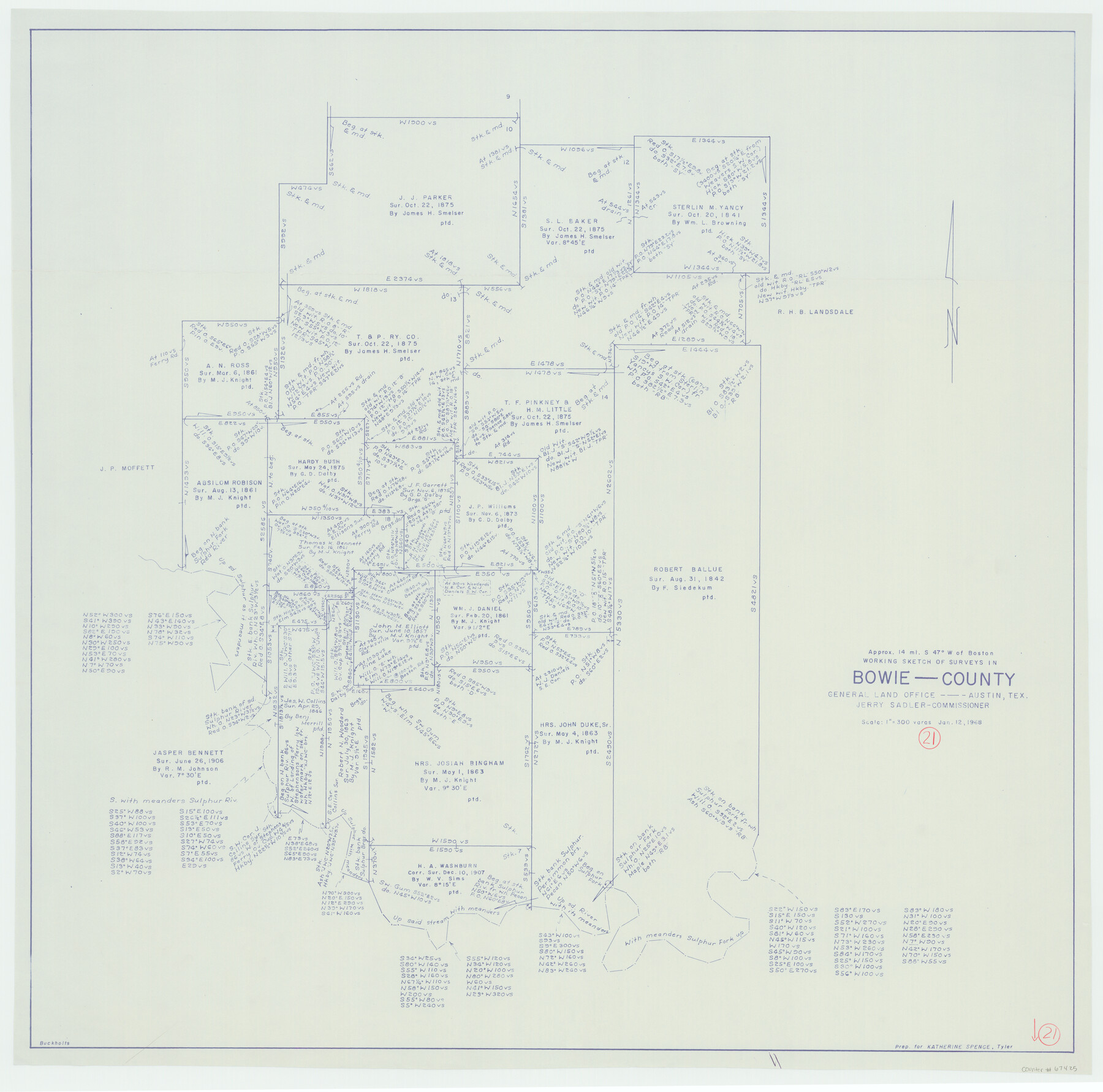
Bowie County Working Sketch 21
-
Map/Doc
67425
-
Collection
General Map Collection
-
Object Dates
1/12/1968 (Creation Date)
-
People and Organizations
Roy Buckholts (Draftsman)
Jerry Sadler (GLO Commissioner)
-
Counties
Bowie
-
Subjects
Surveying Working Sketch
-
Height x Width
35.9 x 36.3 inches
91.2 x 92.2 cm
-
Scale
1" = 300 varas
-
Comments
Surveys located about 14 miles South 47 degrees West of Boston, Texas.
Part of: General Map Collection
Chart of the West Indies and Spanish Dominions in North America

Print $20.00
- Digital $50.00
Chart of the West Indies and Spanish Dominions in North America
1803
Size 25.6 x 39.2 inches
Map/Doc 97138
Upton County Working Sketch 32

Print $40.00
- Digital $50.00
Upton County Working Sketch 32
1956
Size 55.4 x 37.9 inches
Map/Doc 69528
[Galveston, Harrisburg & San Antonio through El Paso County]
![64013, [Galveston, Harrisburg & San Antonio through El Paso County], General Map Collection](https://historictexasmaps.com/wmedia_w700/maps/64013.tif.jpg)
Print $20.00
- Digital $50.00
[Galveston, Harrisburg & San Antonio through El Paso County]
1906
Size 13.5 x 33.5 inches
Map/Doc 64013
Gonzales County Working Sketch 3

Print $20.00
- Digital $50.00
Gonzales County Working Sketch 3
1943
Size 37.8 x 41.5 inches
Map/Doc 63218
Outer Continental Shelf Leasing Maps (Louisiana Offshore Operations)

Print $20.00
- Digital $50.00
Outer Continental Shelf Leasing Maps (Louisiana Offshore Operations)
1955
Size 11.1 x 13.3 inches
Map/Doc 76090
Edwards County Rolled Sketch 17

Print $20.00
- Digital $50.00
Edwards County Rolled Sketch 17
1945
Size 27.6 x 19.4 inches
Map/Doc 5806
Sabine Pass and mouth of the River Sabine in the sea

Print $20.00
- Digital $50.00
Sabine Pass and mouth of the River Sabine in the sea
1840
Size 22.5 x 18.4 inches
Map/Doc 65382
Calhoun County Rolled Sketch 6

Print $20.00
- Digital $50.00
Calhoun County Rolled Sketch 6
Size 24.0 x 22.5 inches
Map/Doc 5362
Flight Mission No. BRE-2P, Frame 44, Nueces County

Print $20.00
- Digital $50.00
Flight Mission No. BRE-2P, Frame 44, Nueces County
1956
Size 18.7 x 22.9 inches
Map/Doc 86746
Reagan County Working Sketch 15

Print $20.00
- Digital $50.00
Reagan County Working Sketch 15
1949
Size 27.3 x 33.0 inches
Map/Doc 71857
Eastland County Sketch File 12

Print $10.00
- Digital $50.00
Eastland County Sketch File 12
1879
Size 9.3 x 8.4 inches
Map/Doc 21588
DeWitt County Rolled Sketch 3A

Print $20.00
- Digital $50.00
DeWitt County Rolled Sketch 3A
1950
Size 25.3 x 35.2 inches
Map/Doc 5704
You may also like
Kent County Working Sketch 2

Print $20.00
- Digital $50.00
Kent County Working Sketch 2
1947
Size 43.7 x 42.7 inches
Map/Doc 70008
Flight Mission No. BRE-2P, Frame 108, Nueces County

Print $20.00
- Digital $50.00
Flight Mission No. BRE-2P, Frame 108, Nueces County
1956
Size 18.5 x 22.5 inches
Map/Doc 86793
Walker County Working Sketch 14

Print $40.00
- Digital $50.00
Walker County Working Sketch 14
1958
Size 19.8 x 51.0 inches
Map/Doc 72294
Travis County Sketch File 61

Print $8.00
- Digital $50.00
Travis County Sketch File 61
1948
Size 14.4 x 8.8 inches
Map/Doc 38427
Wood County Working Sketch 9

Print $20.00
- Digital $50.00
Wood County Working Sketch 9
1943
Size 36.0 x 28.5 inches
Map/Doc 62009
[Surveys along the Texas coast across from Mustang Island]
![346, [Surveys along the Texas coast across from Mustang Island], General Map Collection](https://historictexasmaps.com/wmedia_w700/maps/346.tif.jpg)
Print $2.00
- Digital $50.00
[Surveys along the Texas coast across from Mustang Island]
1841
Size 11.3 x 7.3 inches
Map/Doc 346
Burnet County Working Sketch 15

Print $20.00
- Digital $50.00
Burnet County Working Sketch 15
1979
Size 38.2 x 30.4 inches
Map/Doc 67858
[Capitol Leagues in Lamb County]
![91015, [Capitol Leagues in Lamb County], Twichell Survey Records](https://historictexasmaps.com/wmedia_w700/maps/91015-1.tif.jpg)
Print $2.00
- Digital $50.00
[Capitol Leagues in Lamb County]
1912
Size 12.3 x 8.8 inches
Map/Doc 91015
Flight Mission No. CLL-1N, Frame 77, Willacy County

Print $20.00
- Digital $50.00
Flight Mission No. CLL-1N, Frame 77, Willacy County
1954
Size 18.4 x 22.1 inches
Map/Doc 87023
[Surveys along the Colorado River]
![112, [Surveys along the Colorado River], General Map Collection](https://historictexasmaps.com/wmedia_w700/maps/112.tif.jpg)
Print $2.00
- Digital $50.00
[Surveys along the Colorado River]
1841
Size 12.2 x 8.3 inches
Map/Doc 112
DeWitt County Sketch File 8

Print $4.00
- Digital $50.00
DeWitt County Sketch File 8
1876
Size 8.5 x 5.2 inches
Map/Doc 20818
DeWitt County Boundary File 2a

Print $2.00
- Digital $50.00
DeWitt County Boundary File 2a
Size 10.7 x 8.1 inches
Map/Doc 52513