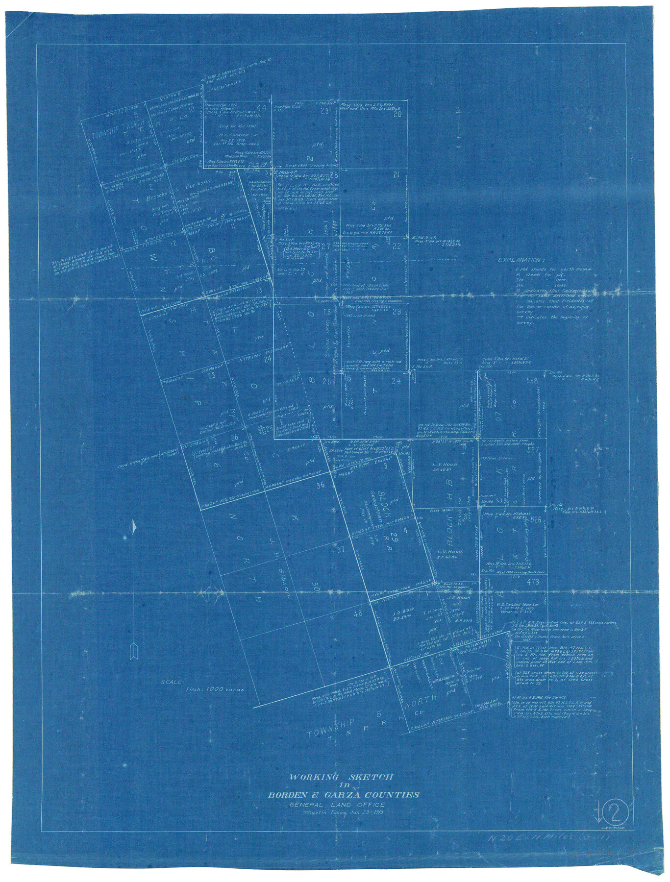
Borden County Working Sketch 2
-
Map/Doc
67462
-
Collection
General Map Collection
-
Object Dates
1/23/1913 (Creation Date)
-
People and Organizations
J.W. Pritchett (Draftsman)
-
Counties
Borden Garza
-
Subjects
Surveying Working Sketch
-
Height x Width
24.6 x 18.4 inches
62.5 x 46.7 cm
-
Scale
1" = 1000 varas
-
Comments
Surveys located about 11 miles North 20 degrees East of Gail, Texas.
Part of: General Map Collection
Flight Mission No. BRA-17M, Frame 3, Jefferson County

Print $20.00
- Digital $50.00
Flight Mission No. BRA-17M, Frame 3, Jefferson County
1953
Size 18.7 x 22.3 inches
Map/Doc 85783
Victoria County Sketch File 14

Print $10.00
- Digital $50.00
Victoria County Sketch File 14
2002
Size 11.0 x 8.5 inches
Map/Doc 95398
Baylor County Boundary File 13

Print $44.00
- Digital $50.00
Baylor County Boundary File 13
Size 4.3 x 9.7 inches
Map/Doc 50424
La Salle County Sketch File 2

Print $14.00
- Digital $50.00
La Salle County Sketch File 2
1857
Size 10.1 x 15.5 inches
Map/Doc 29445
Palo Pinto County

Print $20.00
- Digital $50.00
Palo Pinto County
Size 23.7 x 18.6 inches
Map/Doc 3936
Map of Galveston County

Print $20.00
- Digital $50.00
Map of Galveston County
1883
Size 18.8 x 26.8 inches
Map/Doc 3573
Pecos County Rolled Sketch 22

Print $20.00
- Digital $50.00
Pecos County Rolled Sketch 22
1886
Size 24.3 x 37.0 inches
Map/Doc 93455
Newton County Rolled Sketch 25

Print $20.00
- Digital $50.00
Newton County Rolled Sketch 25
1893
Size 22.4 x 18.7 inches
Map/Doc 6853
Clay County Sketch File 24a

Print $7.00
- Digital $50.00
Clay County Sketch File 24a
1881
Size 11.0 x 8.7 inches
Map/Doc 18439
Hudspeth County Sketch File 10

Print $4.00
- Digital $50.00
Hudspeth County Sketch File 10
1900
Size 11.2 x 8.8 inches
Map/Doc 26899
Bandera County Working Sketch 16d

Print $20.00
- Digital $50.00
Bandera County Working Sketch 16d
1941
Size 19.1 x 23.2 inches
Map/Doc 67612

You may also like
Harrison County Working Sketch 14

Print $20.00
- Digital $50.00
Harrison County Working Sketch 14
1961
Size 35.6 x 32.0 inches
Map/Doc 66034

Map of The Surveyed Part of Peters Colony Texas

Print $40.00
- Digital $50.00
Map of The Surveyed Part of Peters Colony Texas
1852
Size 54.0 x 28.8 inches
Map/Doc 3155
Donley County Sketch File B3

Print $20.00
- Digital $50.00
Donley County Sketch File B3
1918
Size 22.0 x 15.0 inches
Map/Doc 11373
Angelina County

Print $40.00
- Digital $50.00
Angelina County
1945
Size 38.9 x 49.3 inches
Map/Doc 77200
Amérique Septentrionale

Print $20.00
- Digital $50.00
Amérique Septentrionale
1845
Size 14.2 x 21.0 inches
Map/Doc 93780
Lipscomb County Sketch File 4

Print $56.00
- Digital $50.00
Lipscomb County Sketch File 4
1910
Size 11.2 x 8.7 inches
Map/Doc 30233
[Southeast part of Block D and Blocks DD, C31-C37, AX, G and H]
![92012, [Southeast part of Block D and Blocks DD, C31-C37, AX, G and H], Twichell Survey Records](https://historictexasmaps.com/wmedia_w700/maps/92012-1.tif.jpg)
Print $20.00
- Digital $50.00
[Southeast part of Block D and Blocks DD, C31-C37, AX, G and H]
Size 21.4 x 15.0 inches
Map/Doc 92012
Scurry County Rolled Sketch 5

Print $40.00
- Digital $50.00
Scurry County Rolled Sketch 5
Size 48.4 x 41.1 inches
Map/Doc 9913
Flight Mission No. CGI-3N, Frame 99, Cameron County

Print $20.00
- Digital $50.00
Flight Mission No. CGI-3N, Frame 99, Cameron County
1954
Size 18.5 x 22.1 inches
Map/Doc 84579
Old Miscellaneous File 26

Print $4.00
- Digital $50.00
Old Miscellaneous File 26
Size 14.3 x 9.0 inches
Map/Doc 75634
Gillespie County Rolled Sketch 7

Print $20.00
- Digital $50.00
Gillespie County Rolled Sketch 7
2008
Size 18.9 x 18.8 inches
Map/Doc 88818