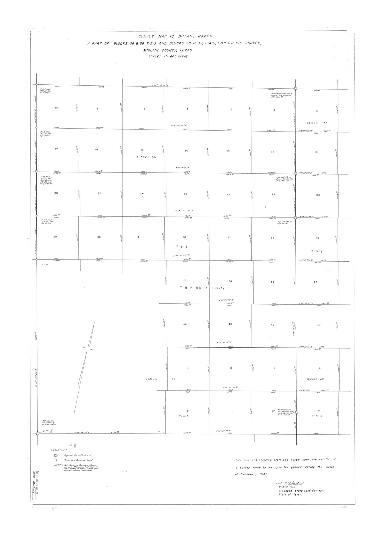
Midland County Rolled Sketch 6
Survey map of Bryant Ranch, a part of Blocks 38 & 39, T-3-S and Blocks 38 & 39, T-4-S, T. & P. R.R. Co. survey, Midland County, Texas
-
Map/Doc
6764
-
Collection
General Map Collection
-
Object Dates
1951 (Creation Date)
1952/1/21 (File Date)
-
People and Organizations
T.O. Wallis (Surveyor/Engineer)
-
Counties
Midland
-
Subjects
Surveying Rolled Sketch
-
Height x Width
39.8 x 28.6 inches
101.1 x 72.6 cm
-
Scale
1" = 600 varas
-
Comments
See Midland County Sketch File 14 (31578) for report.
Related maps
Midland County Sketch File 14

Print $8.00
- Digital $50.00
Midland County Sketch File 14
1951
Size 10.9 x 8.7 inches
Map/Doc 31578
Part of: General Map Collection
Guadalupe County Sketch File 2

Print $4.00
- Digital $50.00
Guadalupe County Sketch File 2
1848
Size 9.4 x 8.3 inches
Map/Doc 24648
Webb County Rolled Sketch 53

Print $40.00
- Digital $50.00
Webb County Rolled Sketch 53
1944
Size 84.0 x 32.3 inches
Map/Doc 63914
Aransas County NRC Article 33.136 Sketch 2

Print $26.00
- Digital $50.00
Aransas County NRC Article 33.136 Sketch 2
2001
Size 18.6 x 24.2 inches
Map/Doc 61643
Flight Mission No. CRK-5P, Frame 159, Refugio County

Print $20.00
- Digital $50.00
Flight Mission No. CRK-5P, Frame 159, Refugio County
1956
Size 18.6 x 22.5 inches
Map/Doc 86940
Wise County Working Sketch 4

Print $20.00
- Digital $50.00
Wise County Working Sketch 4
1948
Size 33.2 x 31.5 inches
Map/Doc 72618
Terrell County

Print $20.00
- Digital $50.00
Terrell County
1931
Size 40.0 x 33.4 inches
Map/Doc 77433
Nolan County Sketch File 1

Print $48.00
- Digital $50.00
Nolan County Sketch File 1
1890
Size 14.1 x 8.5 inches
Map/Doc 32470
Kerr County Working Sketch 33

Print $20.00
- Digital $50.00
Kerr County Working Sketch 33
Size 30.0 x 33.7 inches
Map/Doc 70064
Flight Mission No. DAG-21K, Frame 89, Matagorda County

Print $20.00
- Digital $50.00
Flight Mission No. DAG-21K, Frame 89, Matagorda County
1952
Size 18.5 x 22.3 inches
Map/Doc 86418
Edwards County Working Sketch 28

Print $20.00
- Digital $50.00
Edwards County Working Sketch 28
1946
Size 30.0 x 33.5 inches
Map/Doc 68904
The great railroad routes to the Pacific, and their connections

Print $20.00
- Digital $50.00
The great railroad routes to the Pacific, and their connections
1869
Size 16.3 x 29.4 inches
Map/Doc 96974
Jones County Sketch File 10

Print $20.00
- Digital $50.00
Jones County Sketch File 10
1875
Size 14.3 x 22.2 inches
Map/Doc 11900
You may also like
Upton County Sketch File 36

Print $14.00
- Digital $50.00
Upton County Sketch File 36
1952
Size 11.3 x 8.8 inches
Map/Doc 38893
Floyd County Boundary File 1

Print $30.00
- Digital $50.00
Floyd County Boundary File 1
Size 8.9 x 4.2 inches
Map/Doc 53445
Nueces County Rolled Sketch 54

Print $67.00
- Digital $50.00
Nueces County Rolled Sketch 54
1978
Size 9.8 x 15.0 inches
Map/Doc 47875
Galveston County Sketch File 74

Print $12.00
- Digital $50.00
Galveston County Sketch File 74
2002
Size 11.3 x 8.7 inches
Map/Doc 77526
Bandera County Working Sketch 4

Print $20.00
- Digital $50.00
Bandera County Working Sketch 4
1914
Size 18.6 x 19.3 inches
Map/Doc 67597
Terrell County Sketch File 8

Print $6.00
- Digital $50.00
Terrell County Sketch File 8
Size 11.4 x 10.2 inches
Map/Doc 37902
Leon County Working Sketch 50

Print $20.00
- Digital $50.00
Leon County Working Sketch 50
1981
Size 28.9 x 24.2 inches
Map/Doc 70449
United States - Gulf Coast - From Latitude 26° 33' to the Rio Grande Texas

Print $20.00
- Digital $50.00
United States - Gulf Coast - From Latitude 26° 33' to the Rio Grande Texas
1916
Size 27.9 x 18.3 inches
Map/Doc 72838
Rockwall County Boundary File 2

Print $12.00
- Digital $50.00
Rockwall County Boundary File 2
Size 14.4 x 8.9 inches
Map/Doc 58385
Flight Mission No. BRA-9M, Frame 66, Jefferson County

Print $20.00
- Digital $50.00
Flight Mission No. BRA-9M, Frame 66, Jefferson County
1953
Size 18.9 x 22.5 inches
Map/Doc 85649
Collingsworth County Sketch File 8

Print $4.00
- Digital $50.00
Collingsworth County Sketch File 8
Size 7.4 x 11.6 inches
Map/Doc 18889
Kaufman County Sketch File 3

Print $20.00
- Digital $50.00
Kaufman County Sketch File 3
1857
Size 25.3 x 18.7 inches
Map/Doc 4856