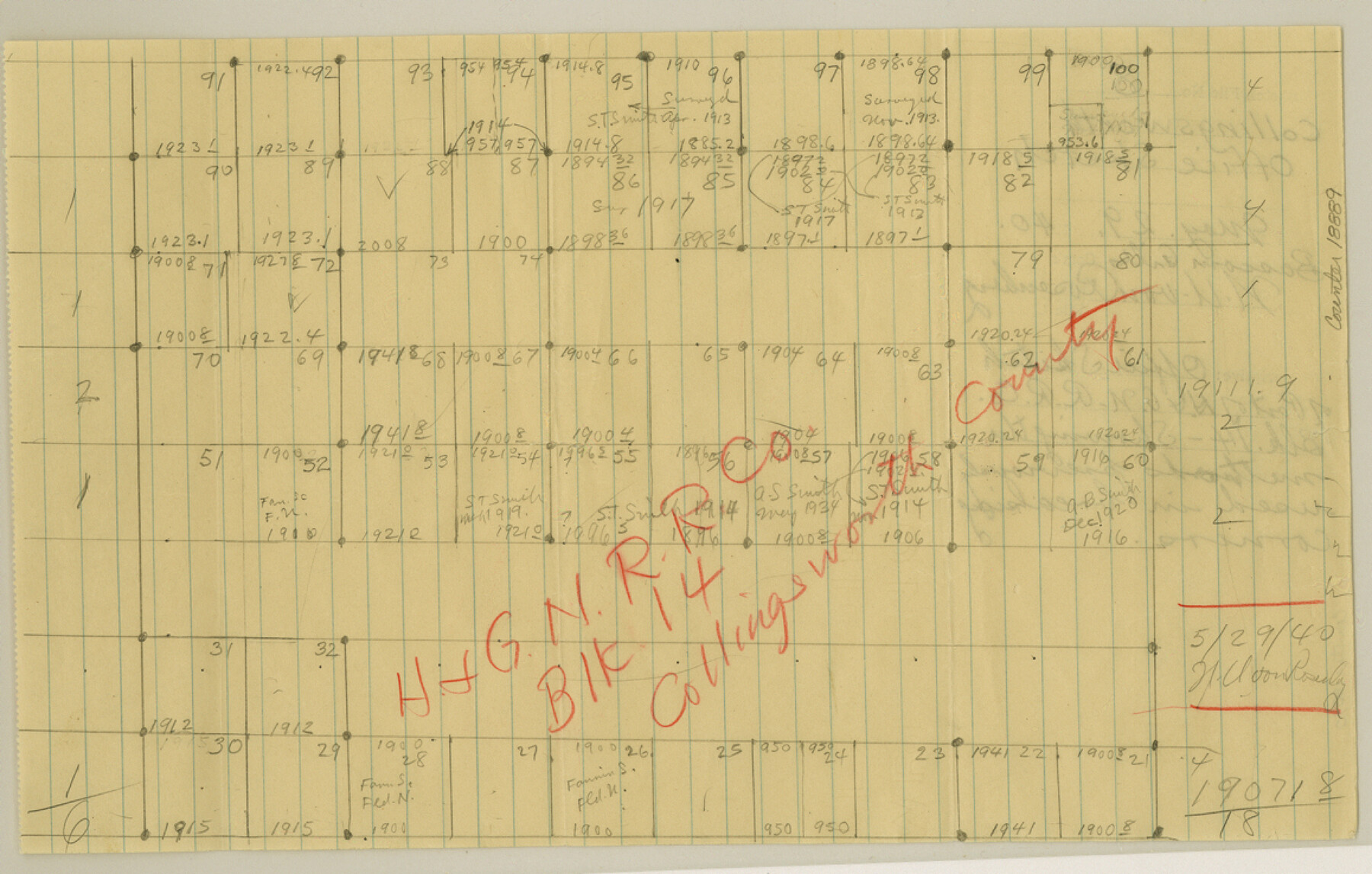
Collingsworth County Sketch File 8
[Office sketch of part of H. & G. N. R.R. Co. Block 14]
-
Map/Doc
18889
-
Collection
General Map Collection
-
Object Dates
1940/5/29 (File Date)
-
Counties
Collingsworth
-
Subjects
Surveying Sketch File
-
Height x Width
7.4 x 11.6 inches
18.8 x 29.5 cm
-
Medium
paper, manuscript
Part of: General Map Collection
The Spot Map of San Antonio including a classified directory showing location of postal zones, points of interest, places of business - and how to get there

Print $20.00
- Digital $50.00
The Spot Map of San Antonio including a classified directory showing location of postal zones, points of interest, places of business - and how to get there
1941
Size 21.2 x 28.2 inches
Map/Doc 95953
Nacogdoches County Working Sketch 3

Print $20.00
- Digital $50.00
Nacogdoches County Working Sketch 3
1935
Size 30.0 x 39.4 inches
Map/Doc 71219
Flight Mission No. DQO-2K, Frame 91, Galveston County

Print $20.00
- Digital $50.00
Flight Mission No. DQO-2K, Frame 91, Galveston County
1952
Size 18.8 x 22.5 inches
Map/Doc 85018
Flight Mission No. CGN-3P, Frame 24, San Patricio County

Print $20.00
- Digital $50.00
Flight Mission No. CGN-3P, Frame 24, San Patricio County
1956
Size 18.5 x 22.3 inches
Map/Doc 86982
Lamar County Sketch File 12

Print $20.00
- Digital $50.00
Lamar County Sketch File 12
Size 19.5 x 23.3 inches
Map/Doc 11967
Coast Chart No. 212 - From Latitude 26° 33' to the Rio Grande, Texas

Print $20.00
- Digital $50.00
Coast Chart No. 212 - From Latitude 26° 33' to the Rio Grande, Texas
1886
Size 21.9 x 17.5 inches
Map/Doc 73505
Goliad County Sketch File 13

Print $8.00
- Digital $50.00
Goliad County Sketch File 13
1856
Size 12.4 x 8.0 inches
Map/Doc 24239
Leon County Working Sketch 48

Print $20.00
- Digital $50.00
Leon County Working Sketch 48
1980
Size 29.2 x 33.7 inches
Map/Doc 70447
Nacogdoches County Working Sketch 8

Print $20.00
- Digital $50.00
Nacogdoches County Working Sketch 8
1964
Size 28.0 x 22.7 inches
Map/Doc 71224
Flight Mission No. DQO-3K, Frame 30, Galveston County

Print $20.00
- Digital $50.00
Flight Mission No. DQO-3K, Frame 30, Galveston County
1952
Size 18.9 x 22.4 inches
Map/Doc 85071
Right of Way and Track Map, Dayton-Goose Creek Ry. Co., Station 190+00 to Station 401+20

Print $40.00
- Digital $50.00
Right of Way and Track Map, Dayton-Goose Creek Ry. Co., Station 190+00 to Station 401+20
1917
Size 25.4 x 56.8 inches
Map/Doc 64366
You may also like
Rusk County Working Sketch 4

Print $20.00
- Digital $50.00
Rusk County Working Sketch 4
1983
Size 27.2 x 31.7 inches
Map/Doc 63639
Hamilton County Sketch File 24

Print $20.00
- Digital $50.00
Hamilton County Sketch File 24
1953
Size 23.2 x 22.8 inches
Map/Doc 11619
[Sketch showing Wm. B. Jaques survey on Llano River]
![591, [Sketch showing Wm. B. Jaques survey on Llano River], Maddox Collection](https://historictexasmaps.com/wmedia_w700/maps/00591.tif.jpg)
Print $2.00
- Digital $50.00
[Sketch showing Wm. B. Jaques survey on Llano River]
Size 10.9 x 9.0 inches
Map/Doc 591
Jeff Davis County Working Sketch 10

Print $20.00
- Digital $50.00
Jeff Davis County Working Sketch 10
1946
Size 29.3 x 37.0 inches
Map/Doc 66505
Duval County Rolled Sketch 30A

Print $40.00
- Digital $50.00
Duval County Rolled Sketch 30A
1896
Size 59.7 x 40.8 inches
Map/Doc 76145
Pecos County Working Sketch 2

Print $20.00
- Digital $50.00
Pecos County Working Sketch 2
Size 18.1 x 28.3 inches
Map/Doc 71472
[Area around Runnels County School Land and I. & G. N. Block 1]
![91664, [Area around Runnels County School Land and I. & G. N. Block 1], Twichell Survey Records](https://historictexasmaps.com/wmedia_w700/maps/91664-1.tif.jpg)
Print $20.00
- Digital $50.00
[Area around Runnels County School Land and I. & G. N. Block 1]
Size 23.0 x 17.9 inches
Map/Doc 91664
Fractional Township No. 7 South Range No. 7 West of the Indian Meridian, Indian Territory

Print $20.00
- Digital $50.00
Fractional Township No. 7 South Range No. 7 West of the Indian Meridian, Indian Territory
1898
Size 19.2 x 24.4 inches
Map/Doc 75168
Dawson County

Print $20.00
- Digital $50.00
Dawson County
1900
Size 40.5 x 36.3 inches
Map/Doc 66798
[Township 3 North, Blocks 33 and 34, T. & P. RR. Company; Township 4 North, Block 33, T. & P. RR. Company]
![92564, [Township 3 North, Blocks 33 and 34, T. & P. RR. Company; Township 4 North, Block 33, T. & P. RR. Company], Twichell Survey Records](https://historictexasmaps.com/wmedia_w700/maps/92564-1.tif.jpg)
Print $20.00
- Digital $50.00
[Township 3 North, Blocks 33 and 34, T. & P. RR. Company; Township 4 North, Block 33, T. & P. RR. Company]
1911
Size 18.6 x 24.8 inches
Map/Doc 92564
Flight Mission No. DAG-24K, Frame 48, Matagorda County

Print $20.00
- Digital $50.00
Flight Mission No. DAG-24K, Frame 48, Matagorda County
1953
Size 18.5 x 22.1 inches
Map/Doc 86535
Harris County Working Sketch 62

Print $20.00
- Digital $50.00
Harris County Working Sketch 62
1954
Size 41.1 x 37.4 inches
Map/Doc 65954