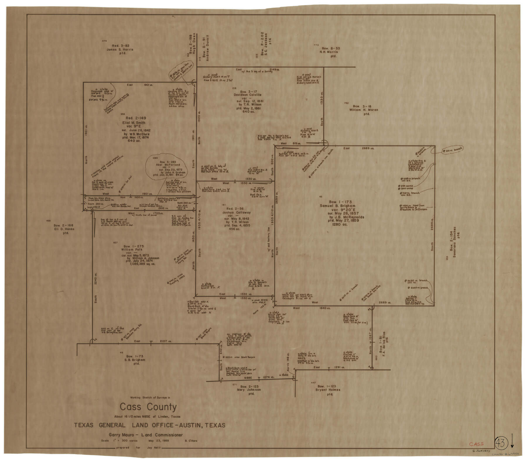
Cass County Working Sketch 43
-
Map/Doc
67946
-
Collection
General Map Collection
-
Object Dates
5/23/1988 (Creation Date)
-
People and Organizations
Bill O'Hara (Draftsman)
-
Counties
Cass
-
Subjects
Surveying Working Sketch
-
Height x Width
25.6 x 29.6 inches
65.0 x 75.2 cm
-
Scale
1" = 300 varas
Part of: General Map Collection
Plat of South 1/2 of Colorado River Channel in McCulloch Co., Texas from Concho County line down river 34 mile 315 varas

Print $40.00
- Digital $50.00
Plat of South 1/2 of Colorado River Channel in McCulloch Co., Texas from Concho County line down river 34 mile 315 varas
1918
Size 41.1 x 144.3 inches
Map/Doc 76044
Jasper County Sketch File 23

Print $20.00
- Digital $50.00
Jasper County Sketch File 23
Size 15.3 x 24.6 inches
Map/Doc 11850
Mason County Sketch File 14

Print $20.00
- Digital $50.00
Mason County Sketch File 14
1884
Size 15.2 x 16.4 inches
Map/Doc 12035
Map of Southeastern Part of Young Territory

Print $40.00
- Digital $50.00
Map of Southeastern Part of Young Territory
1874
Size 54.7 x 30.1 inches
Map/Doc 1989
Atascosa County Rolled Sketch 5B1

Print $20.00
- Digital $50.00
Atascosa County Rolled Sketch 5B1
Size 14.6 x 11.7 inches
Map/Doc 5090
Clay County Boundary File 8

Print $18.00
- Digital $50.00
Clay County Boundary File 8
Size 13.3 x 8.2 inches
Map/Doc 51384

Surveys in Austin's Colony along the Colorado River below the San Antonio Road

Print $20.00
- Digital $50.00
Surveys in Austin's Colony along the Colorado River below the San Antonio Road
1830
Size 38.2 x 13.5 inches
Map/Doc 193
Milam County Rolled Sketch 5

Print $20.00
- Digital $50.00
Milam County Rolled Sketch 5
Size 27.9 x 39.8 inches
Map/Doc 6777
El Paso County Sketch File 14

Print $20.00
- Digital $50.00
El Paso County Sketch File 14
1922
Size 24.0 x 17.2 inches
Map/Doc 11452
Flight Mission No. BRE-2P, Frame 15, Nueces County

Print $20.00
- Digital $50.00
Flight Mission No. BRE-2P, Frame 15, Nueces County
1956
Size 18.4 x 22.4 inches
Map/Doc 86724
Eastland County Working Sketch 35

Print $20.00
- Digital $50.00
Eastland County Working Sketch 35
1962
Size 24.0 x 21.6 inches
Map/Doc 68816
You may also like
America's Fun-Tier: Texas 1966 Official State Highway Map

Digital $50.00
America's Fun-Tier: Texas 1966 Official State Highway Map
Size 28.2 x 36.5 inches
Map/Doc 94324
[T. & P. Block 44, Township 1S]
![90825, [T. & P. Block 44, Township 1S], Twichell Survey Records](https://historictexasmaps.com/wmedia_w700/maps/90825-2.tif.jpg)
Print $20.00
- Digital $50.00
[T. & P. Block 44, Township 1S]
Size 17.9 x 23.3 inches
Map/Doc 90825
Flight Mission No. DCL-4C, Frame 4, Kenedy County

Print $20.00
- Digital $50.00
Flight Mission No. DCL-4C, Frame 4, Kenedy County
1943
Size 18.7 x 22.3 inches
Map/Doc 85805
Flight Mission No. DQO-2K, Frame 142, Galveston County

Print $20.00
- Digital $50.00
Flight Mission No. DQO-2K, Frame 142, Galveston County
1952
Size 18.8 x 22.4 inches
Map/Doc 85039
Eastland County Working Sketch 24

Print $20.00
- Digital $50.00
Eastland County Working Sketch 24
1922
Size 36.1 x 27.1 inches
Map/Doc 68805
Gaines County

Print $40.00
- Digital $50.00
Gaines County
1956
Size 45.1 x 56.6 inches
Map/Doc 95504
Uvalde County Sketch File 18

Print $6.00
- Digital $50.00
Uvalde County Sketch File 18
1883
Size 10.9 x 8.2 inches
Map/Doc 38997
Flight Mission No. BRE-1P, Frame 143, Nueces County

Print $20.00
- Digital $50.00
Flight Mission No. BRE-1P, Frame 143, Nueces County
1956
Size 18.3 x 22.2 inches
Map/Doc 86703
Louisiana and Texas Intracoastal Waterway - Dredging from Freeport Harbor to Caney Creek - Sheet 2

Print $20.00
- Digital $50.00
Louisiana and Texas Intracoastal Waterway - Dredging from Freeport Harbor to Caney Creek - Sheet 2
1940
Size 31.2 x 41.3 inches
Map/Doc 61817
Flight Mission No. DQN-5K, Frame 78, Calhoun County

Print $20.00
- Digital $50.00
Flight Mission No. DQN-5K, Frame 78, Calhoun County
1953
Size 18.6 x 22.3 inches
Map/Doc 84411
Lake Worth Boundary

Print $20.00
- Digital $50.00
Lake Worth Boundary
Size 19.5 x 33.2 inches
Map/Doc 62211
Sketch showing W. C. Powell's two lines at south side of Blk. 37, T.5S

Print $20.00
- Digital $50.00
Sketch showing W. C. Powell's two lines at south side of Blk. 37, T.5S
Size 42.8 x 19.6 inches
Map/Doc 93218