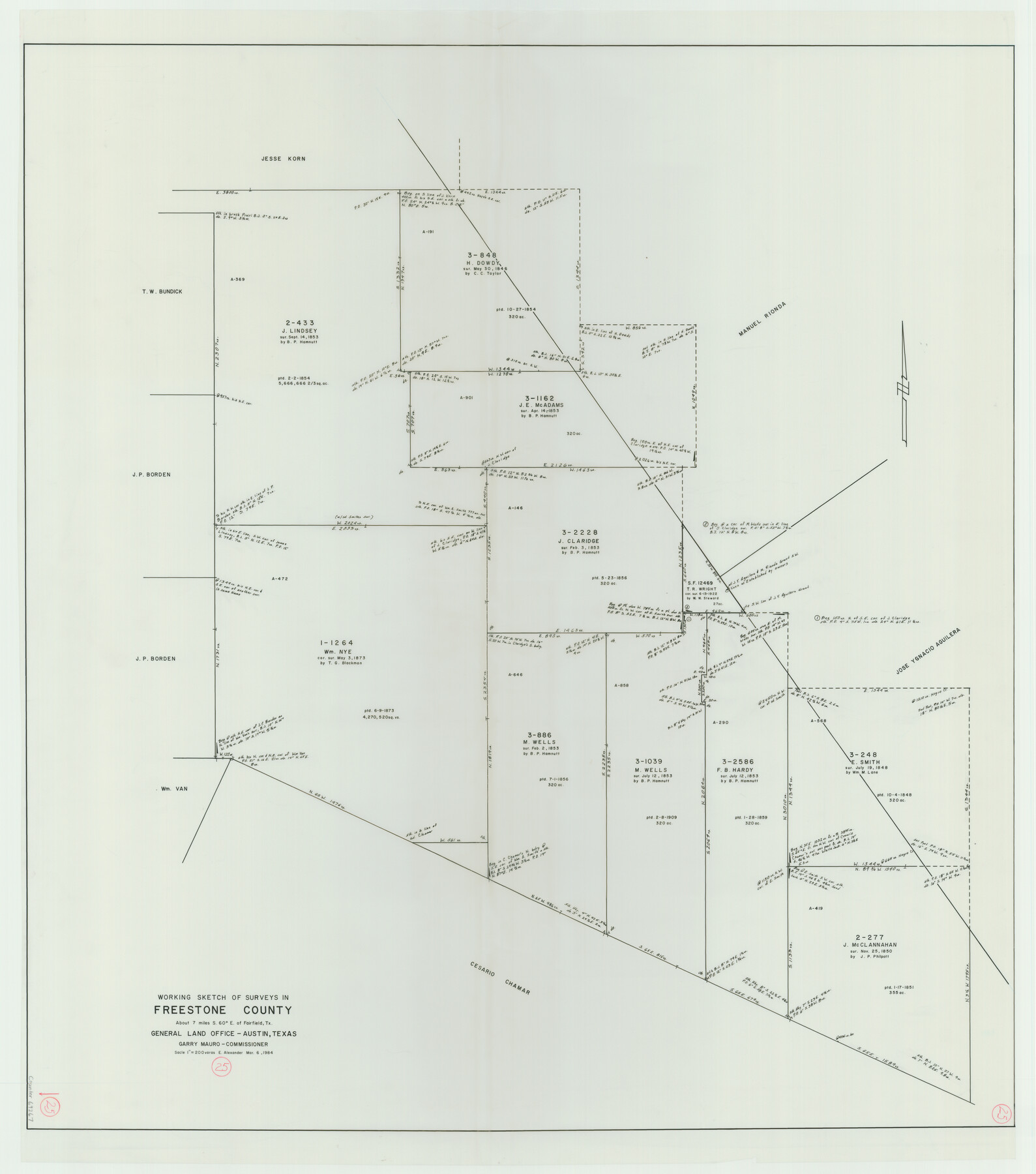
Freestone County Working Sketch 25
-
Map/Doc
69267
-
Collection
General Map Collection
-
Object Dates
3/6/1984 (Creation Date)
-
People and Organizations
Earl Alexander (Draftsman)
-
Counties
Freestone
-
Subjects
Surveying Working Sketch
-
Height x Width
43.5 x 38.4 inches
110.5 x 97.5 cm
-
Scale
1" = 200 varas
Part of: General Map Collection
Grayson County Working Sketch 22

Print $20.00
- Digital $50.00
Grayson County Working Sketch 22
1962
Size 21.5 x 33.6 inches
Map/Doc 63261
Uvalde County Working Sketch 67

Print $20.00
- Digital $50.00
Uvalde County Working Sketch 67
1956
Size 22.8 x 20.9 inches
Map/Doc 75973
Cherokee County Working Sketch 9

Print $20.00
- Digital $50.00
Cherokee County Working Sketch 9
1957
Size 46.9 x 34.0 inches
Map/Doc 67964
Maps & Lists Showing Prison Lands (Oil & Gas) Leased as of June 1955

Digital $50.00
Maps & Lists Showing Prison Lands (Oil & Gas) Leased as of June 1955
Size 11.4 x 7.1 inches
Map/Doc 62865
Aransas County NRC Article 33.136 Location Key Sheet

Print $20.00
- Digital $50.00
Aransas County NRC Article 33.136 Location Key Sheet
1979
Size 27.0 x 23.0 inches
Map/Doc 77006
Crockett County Working Sketch 98

Print $20.00
- Digital $50.00
Crockett County Working Sketch 98
1980
Size 42.8 x 35.9 inches
Map/Doc 68431
Swisher County

Print $20.00
- Digital $50.00
Swisher County
1879
Size 20.9 x 18.7 inches
Map/Doc 4063
Rusk County Sketch File 38

Print $6.00
Rusk County Sketch File 38
1951
Size 11.3 x 8.8 inches
Map/Doc 35576
Reeves County Sketch File 26

Print $4.00
- Digital $50.00
Reeves County Sketch File 26
1964
Size 4.1 x 8.8 inches
Map/Doc 35226
[Beaumont, Sour Lake and Western Ry. Right of Way and Alignment - Frisco]
![64109, [Beaumont, Sour Lake and Western Ry. Right of Way and Alignment - Frisco], General Map Collection](https://historictexasmaps.com/wmedia_w700/maps/64109.tif.jpg)
Print $20.00
- Digital $50.00
[Beaumont, Sour Lake and Western Ry. Right of Way and Alignment - Frisco]
1910
Size 20.3 x 46.2 inches
Map/Doc 64109
Bosque County Working Sketch 23

Print $20.00
- Digital $50.00
Bosque County Working Sketch 23
1984
Size 17.4 x 23.6 inches
Map/Doc 67456
Schleicher County

Print $40.00
- Digital $50.00
Schleicher County
1940
Size 38.7 x 54.9 inches
Map/Doc 73285
You may also like
Archer County Working Sketch 2

Print $20.00
- Digital $50.00
Archer County Working Sketch 2
1907
Size 19.6 x 18.6 inches
Map/Doc 67142
Flight Mission No. CUG-3P, Frame 189, Kleberg County

Print $20.00
- Digital $50.00
Flight Mission No. CUG-3P, Frame 189, Kleberg County
1956
Size 18.6 x 22.2 inches
Map/Doc 86293
Gaines County Sketch File 9

Print $20.00
- Digital $50.00
Gaines County Sketch File 9
Size 34.1 x 17.1 inches
Map/Doc 11524
Kimble County Boundary File 1

Print $4.00
- Digital $50.00
Kimble County Boundary File 1
Size 14.1 x 8.8 inches
Map/Doc 64831
Chambers County Sketch File 41

Print $32.00
- Digital $50.00
Chambers County Sketch File 41
Size 14.7 x 9.1 inches
Map/Doc 17694
Kimble County Working Sketch 69

Print $20.00
- Digital $50.00
Kimble County Working Sketch 69
1965
Size 42.4 x 30.5 inches
Map/Doc 70137
Topography of the Colorado River in the City of Austin

Print $4.00
- Digital $50.00
Topography of the Colorado River in the City of Austin
1941
Size 18.7 x 29.6 inches
Map/Doc 65326
Williamson County Sketch File 13

Print $5.00
- Digital $50.00
Williamson County Sketch File 13
Size 9.3 x 14.3 inches
Map/Doc 40328
Presidio County Working Sketch 126

Print $20.00
- Digital $50.00
Presidio County Working Sketch 126
1987
Size 36.9 x 46.5 inches
Map/Doc 71804
Eastland County Working Sketch 7

Print $3.00
- Digital $50.00
Eastland County Working Sketch 7
1918
Size 15.6 x 10.7 inches
Map/Doc 68788
Orange County Working Sketch 50

Print $20.00
- Digital $50.00
Orange County Working Sketch 50
1991
Size 36.0 x 43.6 inches
Map/Doc 71382
Map No. 1 - Rio Bravo del Norte section of boundary between the United States & Mexico agreed upon by the Joint Commission under the Treaty of Guadalupe Hidalgo

Print $20.00
- Digital $50.00
Map No. 1 - Rio Bravo del Norte section of boundary between the United States & Mexico agreed upon by the Joint Commission under the Treaty of Guadalupe Hidalgo
1852
Size 18.2 x 27.2 inches
Map/Doc 72865