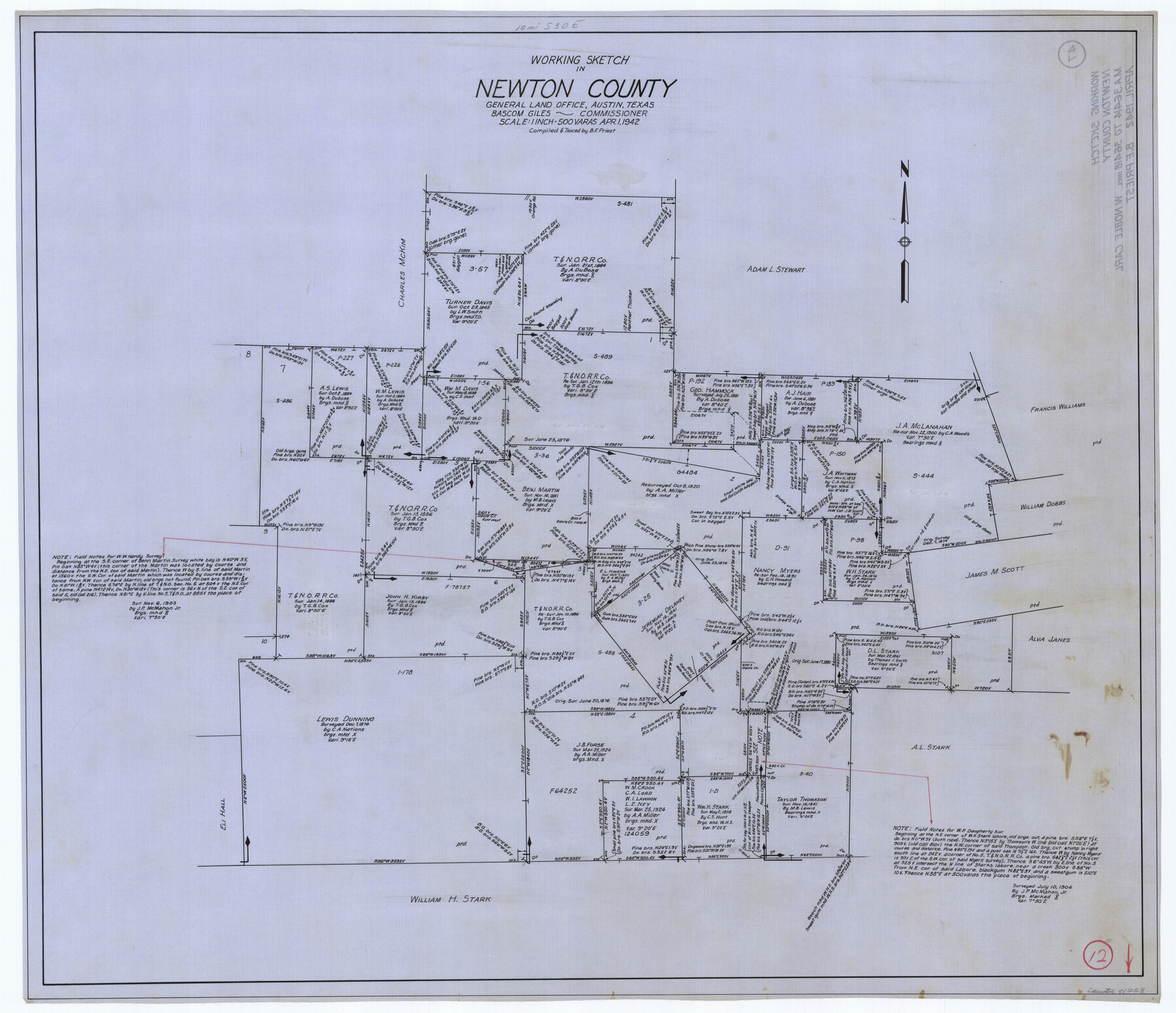
Newton County Working Sketch 12
-
Map/Doc
71258
-
Collection
General Map Collection
-
Object Dates
4/1/1942 (Creation Date)
-
People and Organizations
B.F. Priest (Draftsman)
-
Counties
Newton
-
Subjects
Surveying Working Sketch
-
Height x Width
24.5 x 28.5 inches
62.2 x 72.4 cm
-
Scale
1" = 500 varas
Part of: General Map Collection
Brewster County Rolled Sketch 50

Print $20.00
- Digital $50.00
Brewster County Rolled Sketch 50
1932
Size 21.0 x 26.6 inches
Map/Doc 5226
Mitchell County Sketch File 15

Print $20.00
- Digital $50.00
Mitchell County Sketch File 15
1931
Size 19.2 x 19.6 inches
Map/Doc 12102
Stonewall County Sketch File 19

Print $20.00
- Digital $50.00
Stonewall County Sketch File 19
Size 33.2 x 33.6 inches
Map/Doc 10392
St. Louis, Brownsville & Mexico Railway Location Map from Mile 120 to Rio Grande

Print $40.00
- Digital $50.00
St. Louis, Brownsville & Mexico Railway Location Map from Mile 120 to Rio Grande
1905
Size 19.6 x 67.7 inches
Map/Doc 64170
Flight Mission No. DCL-6C, Frame 20, Kenedy County

Print $20.00
- Digital $50.00
Flight Mission No. DCL-6C, Frame 20, Kenedy County
1943
Size 18.7 x 22.4 inches
Map/Doc 85877
Jackson County Rolled Sketch 3A

Print $20.00
- Digital $50.00
Jackson County Rolled Sketch 3A
1913
Size 23.2 x 22.6 inches
Map/Doc 6337
Cooke County Rolled Sketch 4

Print $20.00
- Digital $50.00
Cooke County Rolled Sketch 4
Size 18.1 x 23.1 inches
Map/Doc 5562
Childress County Sketch File 17

Print $8.00
- Digital $50.00
Childress County Sketch File 17
Size 13.0 x 8.2 inches
Map/Doc 18286
Flight Mission No. CGI-3N, Frame 147, Cameron County

Print $20.00
- Digital $50.00
Flight Mission No. CGI-3N, Frame 147, Cameron County
1954
Size 18.8 x 22.4 inches
Map/Doc 84620
Hardeman County Working Sketch Graphic Index

Print $20.00
- Digital $50.00
Hardeman County Working Sketch Graphic Index
1935
Size 42.9 x 40.5 inches
Map/Doc 76566
Map of R. H. Welder Ranch, San Patricio County, Texas

Print $40.00
- Digital $50.00
Map of R. H. Welder Ranch, San Patricio County, Texas
1953
Size 30.0 x 61.4 inches
Map/Doc 61406
Nueces County Rolled Sketch 51A

Print $20.00
- Digital $50.00
Nueces County Rolled Sketch 51A
1978
Size 27.6 x 39.1 inches
Map/Doc 6890
You may also like
Mason County Boundary File 4

Print $38.00
- Digital $50.00
Mason County Boundary File 4
Size 8.7 x 4.0 inches
Map/Doc 56852
Flight Mission No. BRA-3M, Frame 198, Jefferson County

Print $20.00
- Digital $50.00
Flight Mission No. BRA-3M, Frame 198, Jefferson County
1953
Size 18.7 x 22.4 inches
Map/Doc 85413
Rand, McNally and Co.'s Texas and Indian Territory

Print $20.00
- Digital $50.00
Rand, McNally and Co.'s Texas and Indian Territory
1883
Size 24.3 x 18.6 inches
Map/Doc 4331
Flight Mission No. CUG-1P, Frame 19, Kleberg County

Print $20.00
- Digital $50.00
Flight Mission No. CUG-1P, Frame 19, Kleberg County
1956
Size 18.6 x 22.2 inches
Map/Doc 86109
Dimmit County Rolled Sketch 12

Print $20.00
- Digital $50.00
Dimmit County Rolled Sketch 12
1942
Size 19.8 x 21.5 inches
Map/Doc 5721
Sketch of Surveys on Caranchua and Tres Palacious Bayous, Jackson Co.

Print $2.00
- Digital $50.00
Sketch of Surveys on Caranchua and Tres Palacious Bayous, Jackson Co.
Size 7.9 x 7.8 inches
Map/Doc 69743
Maps of Gulf Intracoastal Waterway, Texas - Sabine River to the Rio Grande and connecting waterways including ship channels

Print $20.00
- Digital $50.00
Maps of Gulf Intracoastal Waterway, Texas - Sabine River to the Rio Grande and connecting waterways including ship channels
1966
Size 14.4 x 20.6 inches
Map/Doc 61996
Map of the country scouted by Colonels McKenzie and Shafter, Capt. R.P. Wilson and others in the years, 1874 & 1875

Print $20.00
- Digital $50.00
Map of the country scouted by Colonels McKenzie and Shafter, Capt. R.P. Wilson and others in the years, 1874 & 1875
1876
Size 43.0 x 31.8 inches
Map/Doc 62972
Newton County Rolled Sketch 26

Print $397.00
- Digital $50.00
Newton County Rolled Sketch 26
1960
Size 10.9 x 15.4 inches
Map/Doc 47265
Sketch J No. 2 Showing the Progress of the Survey of San Francisco Bay and Vicinity Section X From 1850 to 1852

Print $20.00
- Digital $50.00
Sketch J No. 2 Showing the Progress of the Survey of San Francisco Bay and Vicinity Section X From 1850 to 1852
1852
Size 12.3 x 12.7 inches
Map/Doc 97229
Duval County Working Sketch 17

Print $20.00
- Digital $50.00
Duval County Working Sketch 17
1939
Size 14.6 x 25.1 inches
Map/Doc 68730
Map of Brazos County

Print $20.00
- Digital $50.00
Map of Brazos County
1867
Size 23.4 x 16.8 inches
Map/Doc 3327