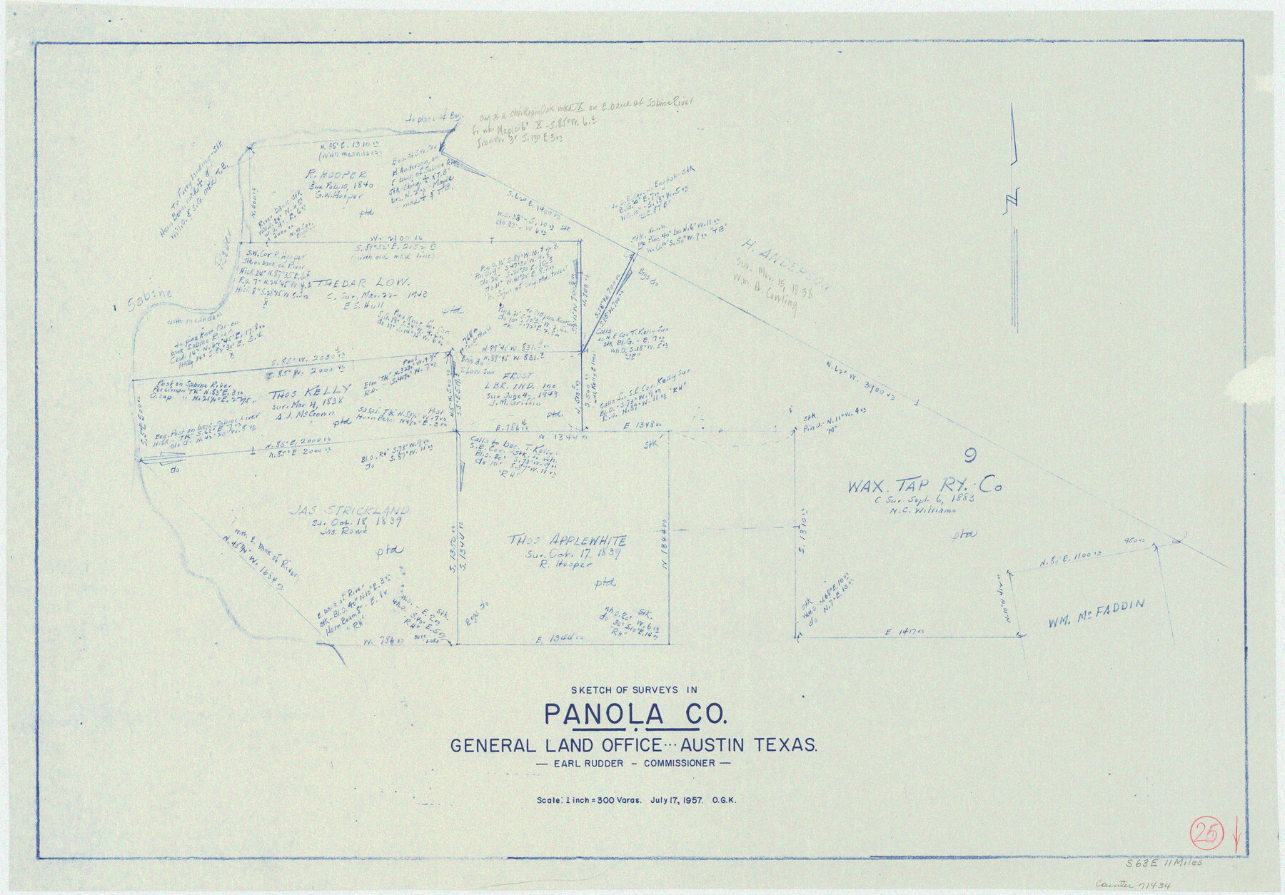
Panola County Working Sketch 25
-
Map/Doc
71434
-
Collection
General Map Collection
-
Object Dates
7/17/1957 (Creation Date)
-
People and Organizations
Otto G. Kurio (Draftsman)
-
Counties
Panola
-
Subjects
Surveying Working Sketch
-
Scale
1" = 300 varas
Part of: General Map Collection
Reeves County Rolled Sketch 27

Print $20.00
- Digital $50.00
Reeves County Rolled Sketch 27
1985
Size 21.6 x 27.6 inches
Map/Doc 7496
Polk County Sketch File 39

Print $24.00
- Digital $50.00
Polk County Sketch File 39
Size 8.3 x 13.3 inches
Map/Doc 34278
Stephens County Sketch File 26

Print $10.00
- Digital $50.00
Stephens County Sketch File 26
Size 14.1 x 8.8 inches
Map/Doc 37096
Map of Galveston, Turtle & East Bays & portions of the Gulf of Mexico in Chambers & Galveston Counties, Texas showing subdivision for mineral development

Print $40.00
- Digital $50.00
Map of Galveston, Turtle & East Bays & portions of the Gulf of Mexico in Chambers & Galveston Counties, Texas showing subdivision for mineral development
1945
Size 46.3 x 52.8 inches
Map/Doc 3068
PSL Field Notes for Block JKL in Hudspeth County

PSL Field Notes for Block JKL in Hudspeth County
Map/Doc 81658
Zapata County Rolled Sketch 10

Print $20.00
- Digital $50.00
Zapata County Rolled Sketch 10
1912
Size 25.4 x 26.6 inches
Map/Doc 8311
Edwards County

Print $20.00
- Digital $50.00
Edwards County
1893
Size 26.7 x 30.2 inches
Map/Doc 4650
El Paso County Rolled Sketch 52

Print $20.00
- Digital $50.00
El Paso County Rolled Sketch 52
1929
Size 18.6 x 24.5 inches
Map/Doc 5846
Flight Mission No. CUG-1P, Frame 23, Kleberg County

Print $20.00
- Digital $50.00
Flight Mission No. CUG-1P, Frame 23, Kleberg County
1956
Size 18.5 x 22.1 inches
Map/Doc 86113
Maverick County Working Sketch 13

Print $20.00
- Digital $50.00
Maverick County Working Sketch 13
1969
Size 27.3 x 35.8 inches
Map/Doc 70905
Tarrant County State Real Property Sketch 3

Print $20.00
- Digital $50.00
Tarrant County State Real Property Sketch 3
2018
Size 35.1 x 23.8 inches
Map/Doc 95402
Blanco County Sketch File 40

Print $4.00
- Digital $50.00
Blanco County Sketch File 40
Size 8.9 x 14.1 inches
Map/Doc 14652
You may also like
[Surveys in Polk and Chambers Counties]
![355, [Surveys in Polk and Chambers Counties], General Map Collection](https://historictexasmaps.com/wmedia_w700/maps/355.tif.jpg)
Print $3.00
- Digital $50.00
[Surveys in Polk and Chambers Counties]
Size 11.7 x 14.4 inches
Map/Doc 355
Frio County Sketch File 2

Print $8.00
- Digital $50.00
Frio County Sketch File 2
Size 8.2 x 7.8 inches
Map/Doc 23104

Goliad County Sketch File 31

Print $6.00
- Digital $50.00
Goliad County Sketch File 31
1897
Size 10.7 x 8.2 inches
Map/Doc 24329
Webb County Sketch File 13a

Print $20.00
- Digital $50.00
Webb County Sketch File 13a
1881
Size 19.0 x 25.7 inches
Map/Doc 12631
Roberts County Boundary File 2d

Print $20.00
- Digital $50.00
Roberts County Boundary File 2d
Size 9.1 x 28.1 inches
Map/Doc 58366
[Surveys in the Travis District along the Colorado River]
![3180, [Surveys in the Travis District along the Colorado River], General Map Collection](https://historictexasmaps.com/wmedia_w700/maps/3180.tif.jpg)
Print $2.00
- Digital $50.00
[Surveys in the Travis District along the Colorado River]
1841
Size 7.0 x 7.3 inches
Map/Doc 3180
Flight Mission No. DCL-6C, Frame 49, Kenedy County

Print $20.00
- Digital $50.00
Flight Mission No. DCL-6C, Frame 49, Kenedy County
1943
Size 18.6 x 22.5 inches
Map/Doc 85891
Loving County Sketch File 4

Print $40.00
- Digital $50.00
Loving County Sketch File 4
1961
Size 20.6 x 24.7 inches
Map/Doc 12014
Victoria County Rolled Sketch 7

Print $40.00
- Digital $50.00
Victoria County Rolled Sketch 7
1945
Size 54.2 x 16.3 inches
Map/Doc 10098
Hood County Working Sketch 5

Print $20.00
- Digital $50.00
Hood County Working Sketch 5
1968
Size 20.7 x 29.1 inches
Map/Doc 66199
Flight Mission No. CGI-4N, Frame 184, Cameron County

Print $20.00
- Digital $50.00
Flight Mission No. CGI-4N, Frame 184, Cameron County
1955
Size 18.7 x 22.3 inches
Map/Doc 84687