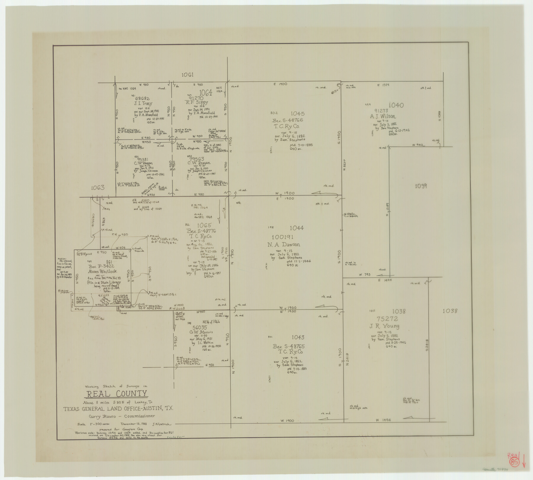
Real County Working Sketch 85
-
Map/Doc
71977
-
Collection
General Map Collection
-
Object Dates
12/12/1988 (Creation Date)
-
People and Organizations
Joan Kilpatrick (Draftsman)
-
Counties
Real
-
Subjects
Surveying Working Sketch
-
Height x Width
27.0 x 30.0 inches
68.6 x 76.2 cm
-
Scale
1" = 300 varas
Part of: General Map Collection
Flight Mission No. DAG-21K, Frame 34, Matagorda County

Print $20.00
- Digital $50.00
Flight Mission No. DAG-21K, Frame 34, Matagorda County
1952
Size 18.7 x 22.3 inches
Map/Doc 86401
Angelina County Working Sketch 23

Print $20.00
- Digital $50.00
Angelina County Working Sketch 23
1953
Size 19.8 x 32.6 inches
Map/Doc 67105
Lavaca County Working Sketch 23

Print $20.00
- Digital $50.00
Lavaca County Working Sketch 23
1985
Size 37.8 x 39.8 inches
Map/Doc 70376
Val Verde County Sketch File 45

Print $20.00
- Digital $50.00
Val Verde County Sketch File 45
1938
Size 21.3 x 16.5 inches
Map/Doc 12586
Map of Clay Co.

Print $40.00
- Digital $50.00
Map of Clay Co.
1896
Size 53.8 x 34.6 inches
Map/Doc 4910
Colorado County Working Sketch 5

Print $40.00
- Digital $50.00
Colorado County Working Sketch 5
1919
Size 82.4 x 44.1 inches
Map/Doc 68105

Hartley County Sketch File 10

Print $57.00
- Digital $50.00
Hartley County Sketch File 10
Size 9.2 x 7.8 inches
Map/Doc 26099
Brazoria County Sketch File 40

Print $8.00
- Digital $50.00
Brazoria County Sketch File 40
1935
Size 14.3 x 8.9 inches
Map/Doc 15049
Val Verde County Sketch File 50

Print $8.00
- Digital $50.00
Val Verde County Sketch File 50
1956
Size 11.5 x 8.9 inches
Map/Doc 39316
Nueces County Rolled Sketch 74

Print $32.00
Nueces County Rolled Sketch 74
1981
Size 18.4 x 25.3 inches
Map/Doc 6932
Live Oak County Sketch File 31

Print $30.00
- Digital $50.00
Live Oak County Sketch File 31
1935
Size 36.0 x 32.5 inches
Map/Doc 10528
You may also like
Reeves County

Print $20.00
- Digital $50.00
Reeves County
1915
Size 46.3 x 36.8 inches
Map/Doc 66998
Gillespie County Sketch File 3a

Print $4.00
- Digital $50.00
Gillespie County Sketch File 3a
1860
Size 7.6 x 8.3 inches
Map/Doc 24131
General Highway Map, Burnet County, Texas

Print $20.00
General Highway Map, Burnet County, Texas
1940
Size 18.6 x 25.2 inches
Map/Doc 79033

Map of La Salle County

Print $20.00
- Digital $50.00
Map of La Salle County
1878
Size 29.8 x 24.8 inches
Map/Doc 3798
Guadalupe County Working Sketch 11

Print $40.00
- Digital $50.00
Guadalupe County Working Sketch 11
1972
Size 67.7 x 45.0 inches
Map/Doc 63320
Hamilton County Sketch File 1

Print $4.00
- Digital $50.00
Hamilton County Sketch File 1
Size 12.5 x 8.2 inches
Map/Doc 24897
Presidio County Rolled Sketch 141

Print $20.00
- Digital $50.00
Presidio County Rolled Sketch 141
Size 40.8 x 28.6 inches
Map/Doc 89064
[Sketch for Mineral Application 16777]
![65654, [Sketch for Mineral Application 16777], General Map Collection](https://historictexasmaps.com/wmedia_w700/maps/65654-1.tif.jpg)
Print $40.00
- Digital $50.00
[Sketch for Mineral Application 16777]
Size 80.1 x 19.7 inches
Map/Doc 65654
Terrell County Working Sketch 7

Print $20.00
- Digital $50.00
Terrell County Working Sketch 7
1915
Size 42.2 x 31.3 inches
Map/Doc 62156
Houston County Rolled Sketch 3

Print $57.00
- Digital $50.00
Houston County Rolled Sketch 3
1935
Size 23.5 x 23.4 inches
Map/Doc 6226
McCulloch County, Texas

Print $20.00
- Digital $50.00
McCulloch County, Texas
1879
Size 24.6 x 18.0 inches
Map/Doc 573