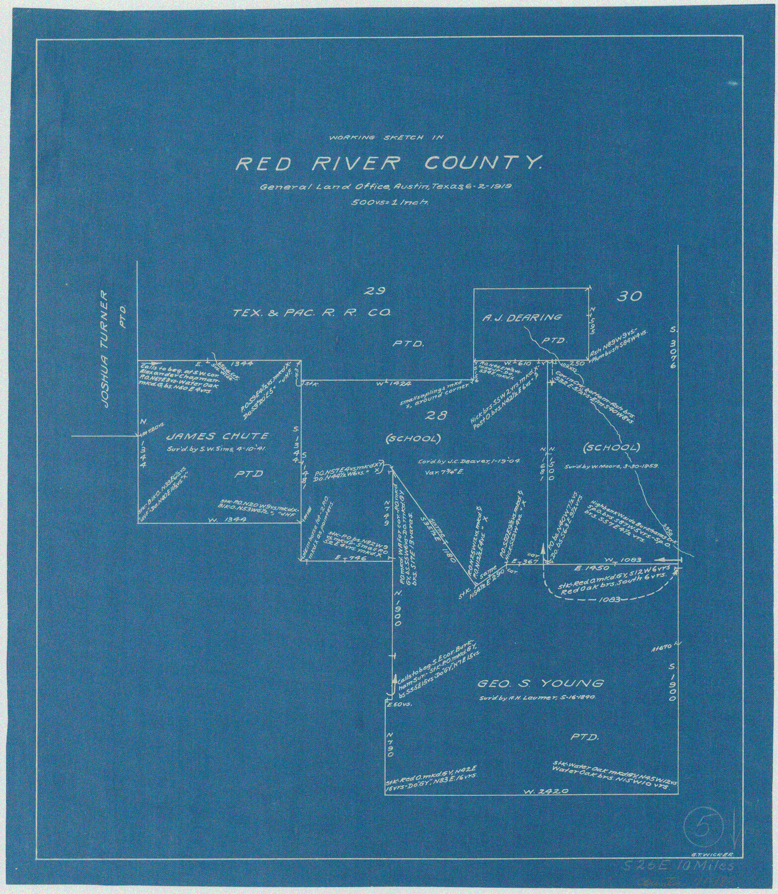
Red River County Working Sketch 5
-
Map/Doc
71988
-
Collection
General Map Collection
-
Object Dates
6/2/1919 (Creation Date)
-
People and Organizations
G.T. Wicker (Draftsman)
-
Counties
Red River
-
Subjects
Surveying Working Sketch
-
Height x Width
14.7 x 12.8 inches
37.3 x 32.5 cm
-
Scale
1" = 500 varas
Part of: General Map Collection
Liberty County Sketch File 56

Print $20.00
- Digital $50.00
Liberty County Sketch File 56
Size 11.9 x 18.7 inches
Map/Doc 11996
Fannin County Sketch File 1

Print $4.00
- Digital $50.00
Fannin County Sketch File 1
1848
Size 9.0 x 7.9 inches
Map/Doc 22443
Childress County Sketch File 16b

Print $6.00
- Digital $50.00
Childress County Sketch File 16b
1884
Size 12.6 x 8.1 inches
Map/Doc 18305
Map of the Surveyed Part of Young District

Print $40.00
- Digital $50.00
Map of the Surveyed Part of Young District
1860
Size 56.3 x 27.3 inches
Map/Doc 87374
Lubbock County Working Sketch 6

Print $20.00
- Digital $50.00
Lubbock County Working Sketch 6
1959
Size 25.1 x 22.4 inches
Map/Doc 70666

Brewster County Working Sketch 88

Print $20.00
- Digital $50.00
Brewster County Working Sketch 88
1973
Size 45.2 x 39.6 inches
Map/Doc 67688
Flight Mission No. BRE-1P, Frame 144, Nueces County

Print $20.00
- Digital $50.00
Flight Mission No. BRE-1P, Frame 144, Nueces County
1956
Size 18.3 x 22.3 inches
Map/Doc 86704
Flight Mission No. CGI-4N, Frame 23, Cameron County

Print $20.00
- Digital $50.00
Flight Mission No. CGI-4N, Frame 23, Cameron County
1954
Size 18.6 x 22.4 inches
Map/Doc 84656
Kimble County Working Sketch 57

Print $20.00
- Digital $50.00
Kimble County Working Sketch 57
1958
Size 20.3 x 30.5 inches
Map/Doc 70125
Edwards County Sketch File 30

Print $10.00
- Digital $50.00
Edwards County Sketch File 30
1920
Size 6.5 x 8.9 inches
Map/Doc 21757
Burnet County Sketch File 14

Print $4.00
- Digital $50.00
Burnet County Sketch File 14
Size 15.1 x 8.9 inches
Map/Doc 16698
You may also like
Dimmit County Working Sketch 9

Print $20.00
- Digital $50.00
Dimmit County Working Sketch 9
1934
Size 36.3 x 42.2 inches
Map/Doc 68670
Index sheet to accompany map of survey for connecting the inland waters along margin of the Gulf of Mexico from Donaldsonville in Louisiana to the Rio Grande River in Texas

Print $20.00
- Digital $50.00
Index sheet to accompany map of survey for connecting the inland waters along margin of the Gulf of Mexico from Donaldsonville in Louisiana to the Rio Grande River in Texas
1873
Size 18.2 x 28.1 inches
Map/Doc 72692
Map of Wharton County

Print $20.00
- Digital $50.00
Map of Wharton County
1884
Size 24.8 x 28.0 inches
Map/Doc 4137
Lavaca County Working Sketch 21

Print $20.00
- Digital $50.00
Lavaca County Working Sketch 21
1982
Size 16.1 x 18.1 inches
Map/Doc 70374
Flight Mission No. CGI-3N, Frame 108, Cameron County

Print $20.00
- Digital $50.00
Flight Mission No. CGI-3N, Frame 108, Cameron County
1954
Size 18.6 x 22.2 inches
Map/Doc 84588
Atascosa County Sketch File 8a

Print $4.00
- Digital $50.00
Atascosa County Sketch File 8a
Size 13.9 x 8.4 inches
Map/Doc 13761
Right of Way and Track Map Houston & Texas Central R.R. operated by the T. & N.O. R.R. Co., Austin Branch

Print $40.00
- Digital $50.00
Right of Way and Track Map Houston & Texas Central R.R. operated by the T. & N.O. R.R. Co., Austin Branch
1918
Size 25.8 x 58.2 inches
Map/Doc 64554
[Surveys in Austin's Colony along the San Bernardo River from the mouth of Peach Creek]
![209, [Surveys in Austin's Colony along the San Bernardo River from the mouth of Peach Creek], General Map Collection](https://historictexasmaps.com/wmedia_w700/maps/209.tif.jpg)
Print $20.00
- Digital $50.00
[Surveys in Austin's Colony along the San Bernardo River from the mouth of Peach Creek]
1821
Size 23.4 x 10.6 inches
Map/Doc 209
Map of Harris County

Print $40.00
- Digital $50.00
Map of Harris County
1896
Size 52.7 x 66.7 inches
Map/Doc 82071
General Highway Map, Zapata County, Texas

Print $20.00
General Highway Map, Zapata County, Texas
1961
Size 18.2 x 24.8 inches
Map/Doc 79721
Palo Pinto County Sketch File A

Print $6.00
- Digital $50.00
Palo Pinto County Sketch File A
Size 8.7 x 4.1 inches
Map/Doc 33389
Nueces County Rolled Sketch 126 A-G

Print $22.00
- Digital $50.00
Nueces County Rolled Sketch 126 A-G
1998
Size 11.3 x 8.8 inches
Map/Doc 8962