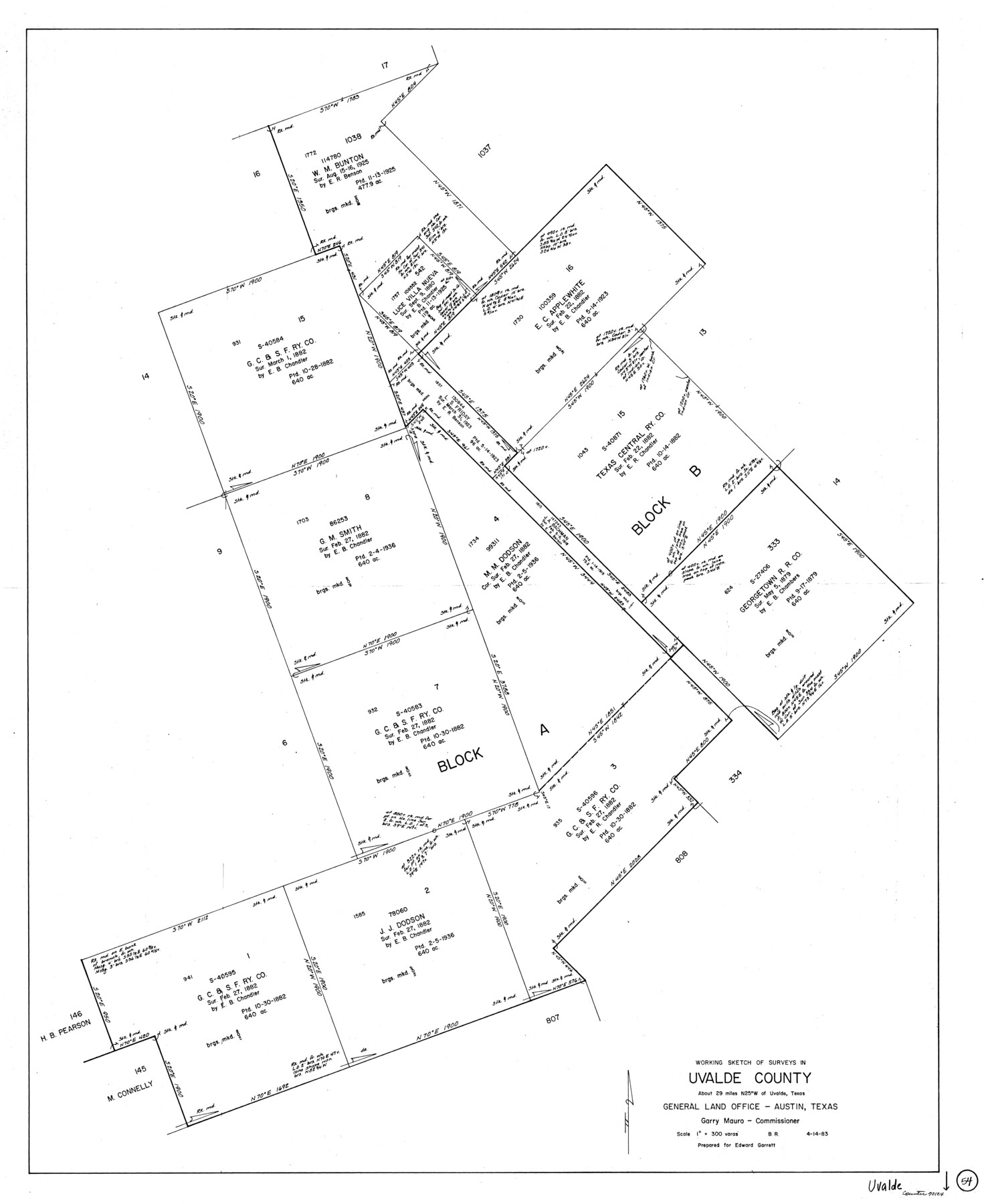
Uvalde County Working Sketch 54
-
Map/Doc
72124
-
Collection
General Map Collection
-
Object Dates
4/14/1983 (Creation Date)
-
People and Organizations
Beverly Robison (Draftsman)
-
Counties
Uvalde
-
Subjects
Surveying Working Sketch
-
Height x Width
39.6 x 32.3 inches
100.6 x 82.0 cm
-
Scale
1" = 300 varas
Part of: General Map Collection
Falls County Sketch File 6

Print $4.00
- Digital $50.00
Falls County Sketch File 6
1848
Size 12.8 x 8.3 inches
Map/Doc 22341
Henderson County Sketch File 7

Print $4.00
- Digital $50.00
Henderson County Sketch File 7
1854
Size 8.6 x 8.6 inches
Map/Doc 26329
Flight Mission No. DCL-5C, Frame 66, Kenedy County

Print $20.00
- Digital $50.00
Flight Mission No. DCL-5C, Frame 66, Kenedy County
1943
Size 18.4 x 22.3 inches
Map/Doc 85849

Flight Mission No. BRA-16M, Frame 85, Jefferson County

Print $20.00
- Digital $50.00
Flight Mission No. BRA-16M, Frame 85, Jefferson County
1953
Size 18.6 x 22.4 inches
Map/Doc 85697
Montague County Working Sketch 36

Print $20.00
- Digital $50.00
Montague County Working Sketch 36
1980
Size 38.4 x 45.1 inches
Map/Doc 71102
Duval County Rolled Sketch 45

Print $20.00
- Digital $50.00
Duval County Rolled Sketch 45
1982
Size 36.3 x 24.5 inches
Map/Doc 5760
Yoakum County Sketch File 6

Print $24.00
- Digital $50.00
Yoakum County Sketch File 6
Size 14.5 x 8.8 inches
Map/Doc 40738
E. N. Gustafson's survey of Southern Portion of Lake Austin, Matagorda Co., TX

Print $20.00
- Digital $50.00
E. N. Gustafson's survey of Southern Portion of Lake Austin, Matagorda Co., TX
1926
Size 36.7 x 42.7 inches
Map/Doc 2922
Archer County Sketch File 14

Print $40.00
- Digital $50.00
Archer County Sketch File 14
1884
Size 19.6 x 23.5 inches
Map/Doc 10826
Anderson County Working Sketch 30

Print $20.00
- Digital $50.00
Anderson County Working Sketch 30
1963
Size 29.8 x 41.6 inches
Map/Doc 67030
Kaufman County Working Sketch 9

Print $20.00
- Digital $50.00
Kaufman County Working Sketch 9
1988
Size 35.9 x 29.8 inches
Map/Doc 66672
You may also like
Galveston County Sketch File 42

Print $20.00
- Digital $50.00
Galveston County Sketch File 42
1899
Size 23.9 x 23.7 inches
Map/Doc 11538
El Paso County Boundary File 23

Print $9.00
- Digital $50.00
El Paso County Boundary File 23
Size 14.9 x 9.4 inches
Map/Doc 53218
Territory of New Mexico

Print $20.00
- Digital $50.00
Territory of New Mexico
1903
Size 23.8 x 19.6 inches
Map/Doc 82011
P. W. Walker Seed and Grain Co. Littlefield, Texas

Print $20.00
- Digital $50.00
P. W. Walker Seed and Grain Co. Littlefield, Texas
1950
Size 36.9 x 15.8 inches
Map/Doc 92404
Guadalupe County

Print $20.00
- Digital $50.00
Guadalupe County
1869
Size 27.7 x 22.3 inches
Map/Doc 3607
[Galveston, Harrisburg & San Antonio Railroad from Cuero to Stockdale]
![64193, [Galveston, Harrisburg & San Antonio Railroad from Cuero to Stockdale], General Map Collection](https://historictexasmaps.com/wmedia_w700/maps/64193.tif.jpg)
Print $20.00
- Digital $50.00
[Galveston, Harrisburg & San Antonio Railroad from Cuero to Stockdale]
1907
Size 13.7 x 34.0 inches
Map/Doc 64193
Flight Mission No. BRA-16M, Frame 182, Jefferson County

Print $20.00
- Digital $50.00
Flight Mission No. BRA-16M, Frame 182, Jefferson County
1953
Size 18.6 x 22.4 inches
Map/Doc 85780
Flight Mission No. DQO-8K, Frame 139, Galveston County

Print $20.00
- Digital $50.00
Flight Mission No. DQO-8K, Frame 139, Galveston County
1952
Size 18.6 x 22.4 inches
Map/Doc 85201
Walker County

Print $20.00
- Digital $50.00
Walker County
1944
Size 44.8 x 38.5 inches
Map/Doc 63106
Fort Bend County Working Sketch 12

Print $40.00
- Digital $50.00
Fort Bend County Working Sketch 12
1940
Size 29.9 x 73.2 inches
Map/Doc 69219
Sabine County, Texas

Print $20.00
- Digital $50.00
Sabine County, Texas
1879
Size 22.1 x 18.6 inches
Map/Doc 751
Baylor County Sketch File 12h

Print $49.00
- Digital $50.00
Baylor County Sketch File 12h
Size 9.3 x 14.7 inches
Map/Doc 14175