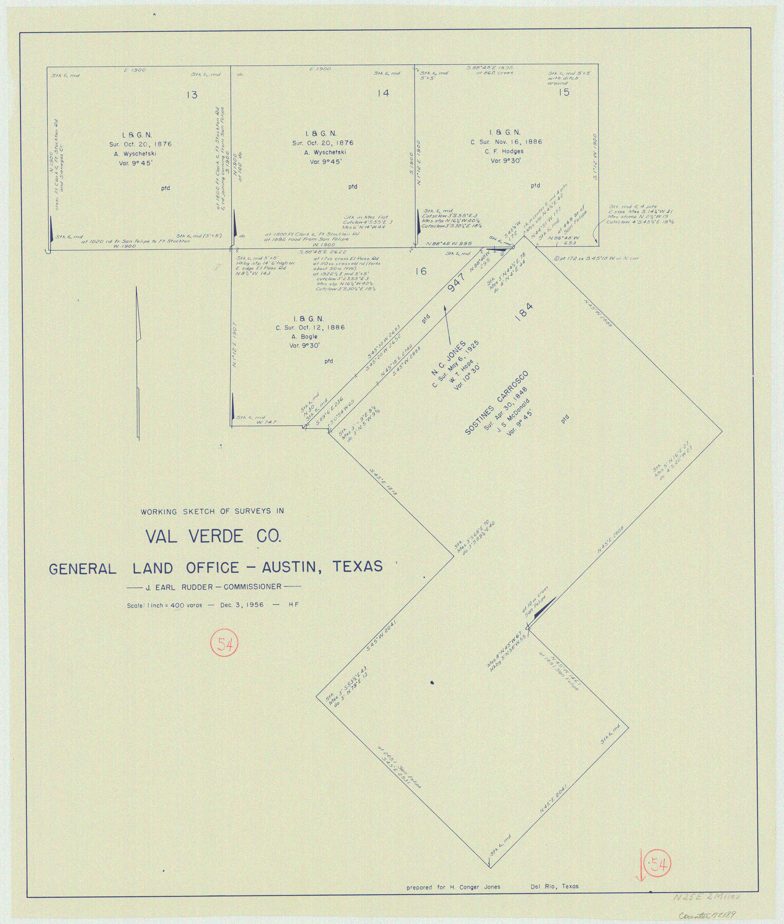
Val Verde County Working Sketch 54
-
Map/Doc
72189
-
Collection
General Map Collection
-
Object Dates
12/3/1956 (Creation Date)
-
People and Organizations
Herman Forbes (Draftsman)
-
Counties
Val Verde
-
Subjects
Surveying Working Sketch
-
Height x Width
24.0 x 20.4 inches
61.0 x 51.8 cm
-
Scale
1" = 400 varas
Part of: General Map Collection
Gulf of Mexico

Print $20.00
- Digital $50.00
Gulf of Mexico
1946
Size 36.2 x 43.7 inches
Map/Doc 73550
[F. W. & D. C. Ry. Co. Alignment and Right of Way Map, Clay County]
![64732, [F. W. & D. C. Ry. Co. Alignment and Right of Way Map, Clay County], General Map Collection](https://historictexasmaps.com/wmedia_w700/maps/64732-GC.tif.jpg)
Print $20.00
- Digital $50.00
[F. W. & D. C. Ry. Co. Alignment and Right of Way Map, Clay County]
1927
Size 18.6 x 11.8 inches
Map/Doc 64732
Gaines County Sketch File 13

Print $40.00
- Digital $50.00
Gaines County Sketch File 13
1954
Size 8.9 x 20.4 inches
Map/Doc 23200
Foard County Working Sketch 7

Print $20.00
- Digital $50.00
Foard County Working Sketch 7
1953
Size 26.0 x 32.7 inches
Map/Doc 69198
Lee County & Burleson County

Print $20.00
- Digital $50.00
Lee County & Burleson County
1867
Size 18.0 x 31.9 inches
Map/Doc 3346
Atascosa County Working Sketch 30

Print $20.00
- Digital $50.00
Atascosa County Working Sketch 30
1980
Size 16.4 x 20.6 inches
Map/Doc 67226
Hood County Sketch File 21

Print $12.00
- Digital $50.00
Hood County Sketch File 21
1873
Size 7.8 x 6.7 inches
Map/Doc 26609
Map of Smith County

Print $20.00
- Digital $50.00
Map of Smith County
1855
Size 21.9 x 21.3 inches
Map/Doc 4038
Red River County Working Sketch 81-1

Print $20.00
- Digital $50.00
Red River County Working Sketch 81-1
1987
Size 14.6 x 18.4 inches
Map/Doc 72064
Galveston County Sketch File 1a

Print $4.00
- Digital $50.00
Galveston County Sketch File 1a
1847
Size 10.2 x 8.9 inches
Map/Doc 23344
Dimmit County Working Sketch 44

Print $20.00
- Digital $50.00
Dimmit County Working Sketch 44
1979
Size 31.7 x 34.0 inches
Map/Doc 68705
Hopkins County Working Sketch 3

Print $20.00
- Digital $50.00
Hopkins County Working Sketch 3
1955
Size 24.2 x 20.0 inches
Map/Doc 66228
You may also like
Flight Mission No. CGI-2N, Frame 180, Cameron County

Print $20.00
- Digital $50.00
Flight Mission No. CGI-2N, Frame 180, Cameron County
1954
Size 18.5 x 22.1 inches
Map/Doc 84540
General Highway Map, Hill County, Texas

Print $20.00
General Highway Map, Hill County, Texas
1961
Size 24.5 x 18.2 inches
Map/Doc 79520
Fractional Township No. 9 South Range No. 23 East of the Indian Meridian, Indian Territory

Print $20.00
- Digital $50.00
Fractional Township No. 9 South Range No. 23 East of the Indian Meridian, Indian Territory
1898
Size 19.2 x 24.4 inches
Map/Doc 75240
Current Miscellaneous File 105

Print $18.00
- Digital $50.00
Current Miscellaneous File 105
Size 8.8 x 14.2 inches
Map/Doc 74680
Kendall County Working Sketch 26

Print $20.00
- Digital $50.00
Kendall County Working Sketch 26
1985
Size 42.5 x 36.0 inches
Map/Doc 66698
[Subdivision surveys of the McCutcheon League near the Bastrop-Caldwell County Line]
![90148, [Subdivision surveys of the McCutcheon League near the Bastrop-Caldwell County Line], Twichell Survey Records](https://historictexasmaps.com/wmedia_w700/maps/90148-1.tif.jpg)
Print $20.00
- Digital $50.00
[Subdivision surveys of the McCutcheon League near the Bastrop-Caldwell County Line]
1923
Size 12.5 x 16.9 inches
Map/Doc 90148
The Judicial District/County of Hamilton. Created, February 2, 1842

Print $20.00
The Judicial District/County of Hamilton. Created, February 2, 1842
2020
Size 14.9 x 21.7 inches
Map/Doc 96329
Hudspeth County Working Sketch 15

Print $20.00
- Digital $50.00
Hudspeth County Working Sketch 15
1954
Size 36.4 x 16.2 inches
Map/Doc 66297
Johnson County Working Sketch 1

Print $20.00
- Digital $50.00
Johnson County Working Sketch 1
Size 16.3 x 21.3 inches
Map/Doc 66614

Stonewall County Sketch File 26

Print $20.00
- Digital $50.00
Stonewall County Sketch File 26
1953
Size 35.7 x 36.8 inches
Map/Doc 10376
Yellow Fever Deaths in Texas and Louisiana

Yellow Fever Deaths in Texas and Louisiana
2022
Size 8.5 x 11.0 inches
Map/Doc 97094