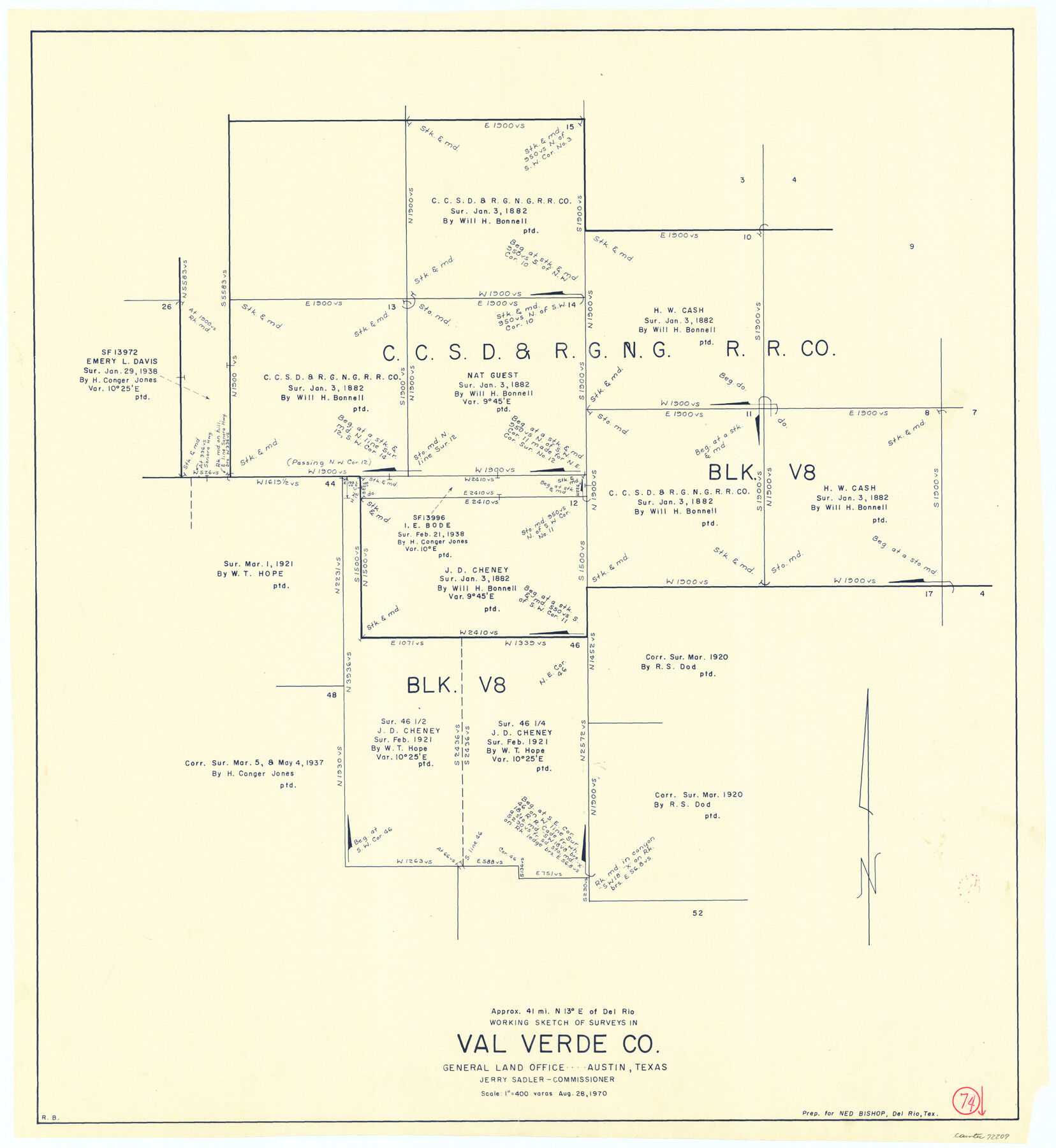
Val Verde County Working Sketch 74
-
Map/Doc
72209
-
Collection
General Map Collection
-
Object Dates
8/28/1970 (Creation Date)
-
People and Organizations
Roy Buckholts (Draftsman)
-
Counties
Val Verde
-
Subjects
Surveying Working Sketch
-
Height x Width
30.7 x 28.3 inches
78.0 x 71.9 cm
-
Scale
1" = 400 varas
Part of: General Map Collection
Travis County Sketch File 49

Print $14.00
- Digital $50.00
Travis County Sketch File 49
1940
Size 14.4 x 8.9 inches
Map/Doc 38380
Flight Mission No. BRA-9M, Frame 66, Jefferson County

Print $20.00
- Digital $50.00
Flight Mission No. BRA-9M, Frame 66, Jefferson County
1953
Size 18.9 x 22.5 inches
Map/Doc 85649
Hunt County Rolled Sketch 3

Print $20.00
- Digital $50.00
Hunt County Rolled Sketch 3
Size 19.1 x 36.0 inches
Map/Doc 6267
Wilbarger County Sketch File 5a

Print $20.00
- Digital $50.00
Wilbarger County Sketch File 5a
Size 13.4 x 19.7 inches
Map/Doc 12690
Nueces County

Print $20.00
- Digital $50.00
Nueces County
1913
Size 25.9 x 34.9 inches
Map/Doc 73252
Map of Navarro County

Print $20.00
- Digital $50.00
Map of Navarro County
1858
Size 19.3 x 25.8 inches
Map/Doc 3912
Carson County Boundary File 9

Print $74.00
- Digital $50.00
Carson County Boundary File 9
Size 9.0 x 8.9 inches
Map/Doc 51175
Bee County Sketch File 4a

Print $4.00
- Digital $50.00
Bee County Sketch File 4a
Size 7.1 x 8.5 inches
Map/Doc 14270
Flight Mission No. BRA-16M, Frame 146, Jefferson County

Print $20.00
- Digital $50.00
Flight Mission No. BRA-16M, Frame 146, Jefferson County
1953
Size 18.4 x 22.3 inches
Map/Doc 85752
Nueces County

Print $20.00
- Digital $50.00
Nueces County
1913
Size 26.9 x 35.9 inches
Map/Doc 95602
Map of the country in the vicinity of San Antonio de Bexar reduced in part from the county map of Bexar with additions by J. Edmd. Blake, 1st Lieut Topl. Engs.

Print $20.00
- Digital $50.00
Map of the country in the vicinity of San Antonio de Bexar reduced in part from the county map of Bexar with additions by J. Edmd. Blake, 1st Lieut Topl. Engs.
1845
Size 18.3 x 26.1 inches
Map/Doc 72721
[Beaumont, Sour Lake and Western Ry. Right of Way and Alignment - Frisco]
![64128, [Beaumont, Sour Lake and Western Ry. Right of Way and Alignment - Frisco], General Map Collection](https://historictexasmaps.com/wmedia_w700/maps/64128.tif.jpg)
Print $20.00
- Digital $50.00
[Beaumont, Sour Lake and Western Ry. Right of Way and Alignment - Frisco]
1910
Size 20.1 x 45.9 inches
Map/Doc 64128
You may also like
Caldwell County

Print $20.00
- Digital $50.00
Caldwell County
1935
Size 36.1 x 40.3 inches
Map/Doc 77227
Rio Grande, Donna Sheet

Print $20.00
- Digital $50.00
Rio Grande, Donna Sheet
1937
Size 37.5 x 37.4 inches
Map/Doc 65117
Donley County Working Sketch 3

Print $40.00
- Digital $50.00
Donley County Working Sketch 3
Size 58.7 x 44.8 inches
Map/Doc 68736
Wharton County Working Sketch Graphic Index

Print $20.00
- Digital $50.00
Wharton County Working Sketch Graphic Index
1946
Size 41.7 x 47.5 inches
Map/Doc 76737
Map of Edwards County, Texas

Print $20.00
- Digital $50.00
Map of Edwards County, Texas
Size 21.5 x 18.2 inches
Map/Doc 92635
[PSL Blks. A55, A56, 77, B1, B2, B6 and and B10]
![89821, [PSL Blks. A55, A56, 77, B1, B2, B6 and and B10], Twichell Survey Records](https://historictexasmaps.com/wmedia_w700/maps/89821-1.tif.jpg)
Print $40.00
- Digital $50.00
[PSL Blks. A55, A56, 77, B1, B2, B6 and and B10]
Size 24.0 x 69.3 inches
Map/Doc 89821
Presidio County Rolled Sketch 82

Print $20.00
- Digital $50.00
Presidio County Rolled Sketch 82
1943
Size 35.5 x 26.1 inches
Map/Doc 7369
Flight Mission No. BRA-7M, Frame 76, Jefferson County

Print $20.00
- Digital $50.00
Flight Mission No. BRA-7M, Frame 76, Jefferson County
1953
Size 18.8 x 22.3 inches
Map/Doc 85498
McCulloch County Sketch File 8

Print $4.00
- Digital $50.00
McCulloch County Sketch File 8
1904
Size 11.3 x 8.7 inches
Map/Doc 31182
[F. W. & D. C. Ry. Co. Alignment and Right of Way Map, Clay County]
![64728, [F. W. & D. C. Ry. Co. Alignment and Right of Way Map, Clay County], General Map Collection](https://historictexasmaps.com/wmedia_w700/maps/64728-1.tif.jpg)
Print $20.00
- Digital $50.00
[F. W. & D. C. Ry. Co. Alignment and Right of Way Map, Clay County]
1927
Size 18.8 x 11.7 inches
Map/Doc 64728
Travis County Rolled Sketch 28

Print $20.00
- Digital $50.00
Travis County Rolled Sketch 28
1941
Size 22.7 x 27.0 inches
Map/Doc 8030
Nueces County Rolled Sketch 129

Print $20.00
- Digital $50.00
Nueces County Rolled Sketch 129
1998
Size 18.1 x 24.5 inches
Map/Doc 7164