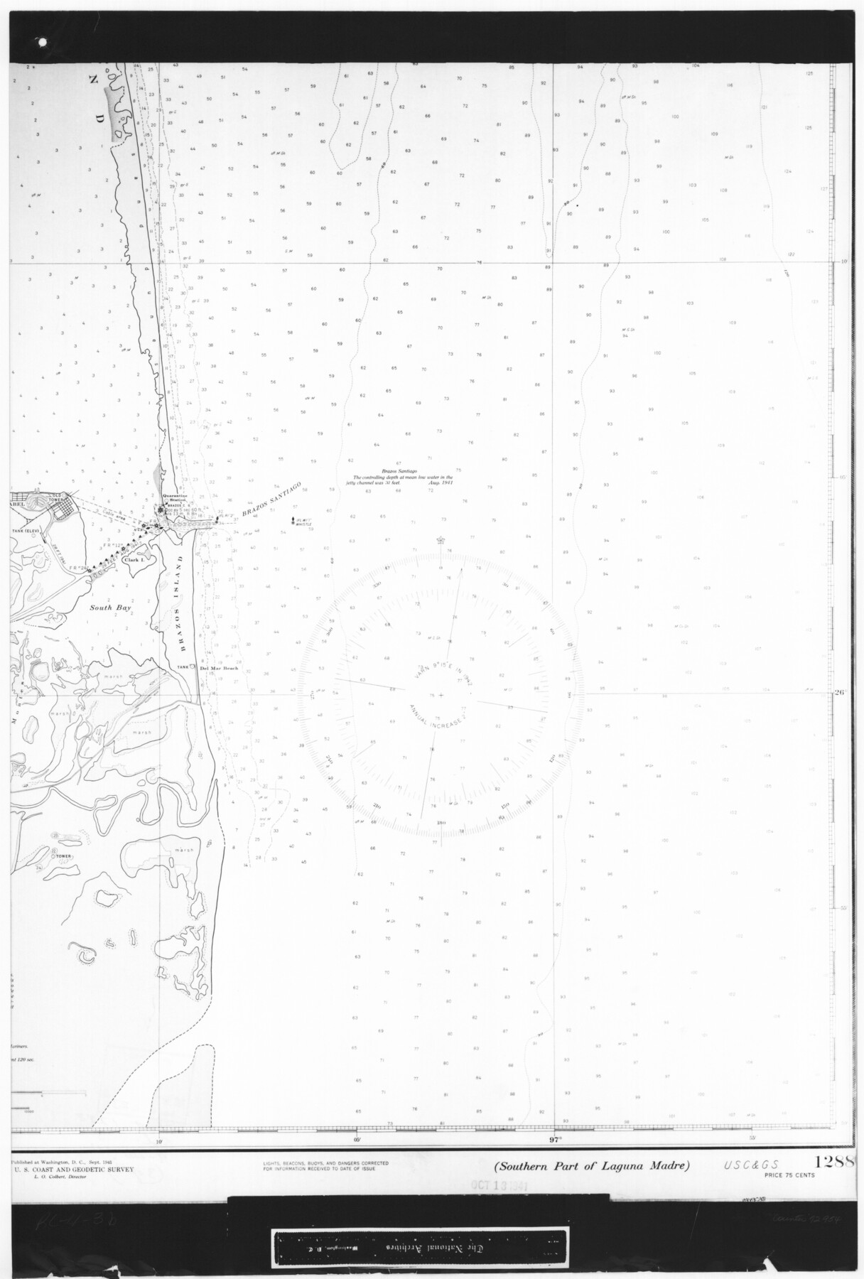
United States - Gulf Coast Texas - Southern part of Laguna Madre
RL-4-3b
-
Map/Doc
72954
-
Collection
General Map Collection
-
Object Dates
1941 (Creation Date)
-
People and Organizations
U. S. Coast and Geodetic Survey (Publisher)
U. S. Coast and Geodetic Survey (Author)
-
Subjects
Nautical Charts
-
Height x Width
27.1 x 18.3 inches
68.8 x 46.5 cm
-
Comments
B/W photostat copy from National Archives in multiple pieces.
Part of: General Map Collection
Cherokee County Boundary File 2

Print $11.00
- Digital $50.00
Cherokee County Boundary File 2
Size 16.1 x 9.9 inches
Map/Doc 51280
Maps of Gulf Intracoastal Waterway, Texas - Sabine River to the Rio Grande and connecting waterways including ship channels

Print $20.00
- Digital $50.00
Maps of Gulf Intracoastal Waterway, Texas - Sabine River to the Rio Grande and connecting waterways including ship channels
1966
Size 14.6 x 22.3 inches
Map/Doc 61954
Montgomery County Working Sketch 51

Print $20.00
- Digital $50.00
Montgomery County Working Sketch 51
1960
Size 38.7 x 40.4 inches
Map/Doc 71158
Llano County Working Sketch 13

Print $20.00
- Digital $50.00
Llano County Working Sketch 13
1987
Size 23.0 x 22.3 inches
Map/Doc 70631
Reagan County Sketch File 28

Print $20.00
- Digital $50.00
Reagan County Sketch File 28
1951
Size 29.6 x 21.7 inches
Map/Doc 12224
Comanche County Sketch File 10

Print $4.00
- Digital $50.00
Comanche County Sketch File 10
1859
Size 8.4 x 16.0 inches
Map/Doc 19070
Ochiltree County Sketch File 6

Print $20.00
- Digital $50.00
Ochiltree County Sketch File 6
1930
Size 9.5 x 32.7 inches
Map/Doc 42203
Palo Duro Canyon Park

Print $20.00
- Digital $50.00
Palo Duro Canyon Park
1950
Size 25.2 x 37.9 inches
Map/Doc 73567
Schleicher County Sketch File 48

Print $4.00
- Digital $50.00
Schleicher County Sketch File 48
1953
Size 11.2 x 8.7 inches
Map/Doc 36558
Webb County Sketch File 2 and 2A

Print $20.00
- Digital $50.00
Webb County Sketch File 2 and 2A
Size 39.8 x 29.6 inches
Map/Doc 10428

Duval County Sketch File 8d

Print $4.00
- Digital $50.00
Duval County Sketch File 8d
1869
Size 10.8 x 8.9 inches
Map/Doc 21302
You may also like
Colorado County Sketch File 6

Print $8.00
- Digital $50.00
Colorado County Sketch File 6
1860
Size 8.4 x 7.0 inches
Map/Doc 18921
Railroad Track Map, H&TCRRCo., Falls County, Texas

Print $4.00
- Digital $50.00
Railroad Track Map, H&TCRRCo., Falls County, Texas
1918
Size 11.8 x 18.6 inches
Map/Doc 62840
Preliminary Re-Plat of Lots 13-20, 45-52, 77-84, and 97-104 James Subdivision

Print $20.00
- Digital $50.00
Preliminary Re-Plat of Lots 13-20, 45-52, 77-84, and 97-104 James Subdivision
1953
Size 11.8 x 36.7 inches
Map/Doc 93222
Flight Mission No. DQO-8K, Frame 76, Galveston County

Print $20.00
- Digital $50.00
Flight Mission No. DQO-8K, Frame 76, Galveston County
1952
Size 18.6 x 22.5 inches
Map/Doc 85180
Harrison County

Print $20.00
- Digital $50.00
Harrison County
1857
Size 20.3 x 21.0 inches
Map/Doc 1116
Culberson County Sketch File 3b

Print $20.00
- Digital $50.00
Culberson County Sketch File 3b
1880
Size 20.3 x 28.0 inches
Map/Doc 11262
Flight Mission No. CRC-3R, Frame 46, Chambers County

Print $20.00
- Digital $50.00
Flight Mission No. CRC-3R, Frame 46, Chambers County
1956
Size 18.6 x 22.5 inches
Map/Doc 84819
Kerr County Working Sketch 16

Print $20.00
- Digital $50.00
Kerr County Working Sketch 16
1954
Size 21.1 x 23.3 inches
Map/Doc 70047
Travis County Working Sketch 39

Print $20.00
- Digital $50.00
Travis County Working Sketch 39
1974
Size 33.1 x 31.7 inches
Map/Doc 69423
Kinney County Rolled Sketch 1

Print $20.00
- Digital $50.00
Kinney County Rolled Sketch 1
Size 25.1 x 36.1 inches
Map/Doc 6533
Medina County Working Sketch 7

Print $20.00
- Digital $50.00
Medina County Working Sketch 7
1952
Size 26.3 x 28.5 inches
Map/Doc 70922
Sabine Pass and mouth of the River Sabine

Print $20.00
- Digital $50.00
Sabine Pass and mouth of the River Sabine
1840
Size 27.0 x 18.3 inches
Map/Doc 72726