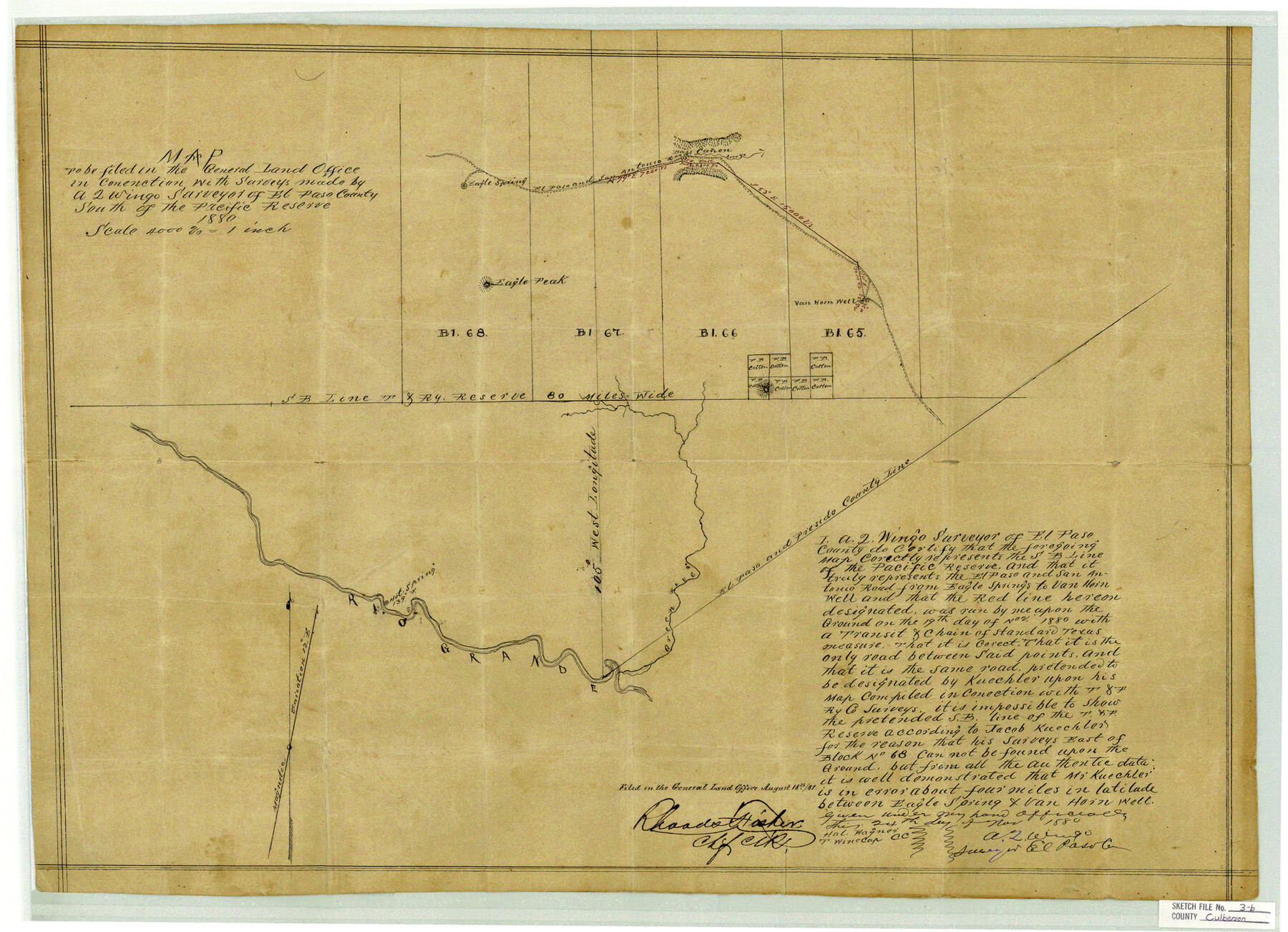
Culberson County Sketch File 3b
A.Q. Wingo Sketch showing T&P Reserve South Boundary Line and San Antonio-El Paso Road from Eagle Springs to Van Horn
-
Map/Doc
11262
-
Collection
General Map Collection
-
Object Dates
1880 (Creation Date)
1881/8/18 (File Date)
-
People and Organizations
A.Q. Wingo (Surveyor/Engineer)
Jacob Kuechler (Surveyor/Engineer)
-
Counties
Culberson El Paso Presidio
-
Subjects
Surveying Sketch File
-
Height x Width
20.3 x 28.0 inches
51.6 x 71.1 cm
-
Medium
paper, manuscript
-
Scale
1:4000
-
Features
Eagle Spring
El Paso and San Antonio Road
El Paso Road
San Antonio Road
Bass Canon
Van Horn Well
Eagle Peak
Hot Spring
Green River
Rio Grande River
Part of: General Map Collection
Armstrong County

Print $20.00
- Digital $50.00
Armstrong County
1904
Size 45.7 x 40.6 inches
Map/Doc 4876
Hunt County Sketch File 17

Print $8.00
- Digital $50.00
Hunt County Sketch File 17
1861
Size 10.6 x 8.2 inches
Map/Doc 27114
Cameron County Rolled Sketch Z1

Print $20.00
- Digital $50.00
Cameron County Rolled Sketch Z1
1937
Size 23.4 x 41.4 inches
Map/Doc 5401
Wilson County Boundary File 5

Print $20.00
- Digital $50.00
Wilson County Boundary File 5
Size 14.4 x 8.7 inches
Map/Doc 60109
Edwards County Working Sketch 15

Print $20.00
- Digital $50.00
Edwards County Working Sketch 15
1927
Size 30.0 x 28.4 inches
Map/Doc 68891
Irion County Working Sketch 8

Print $20.00
- Digital $50.00
Irion County Working Sketch 8
1937
Size 42.0 x 41.0 inches
Map/Doc 66417
Washington County

Print $20.00
- Digital $50.00
Washington County
1863
Size 15.9 x 27.2 inches
Map/Doc 4127
El Paso County Rolled Sketch 53

Print $105.00
- Digital $50.00
El Paso County Rolled Sketch 53
1930
Size 10.1 x 15.3 inches
Map/Doc 44486
Val Verde County Working Sketch 7

Print $20.00
- Digital $50.00
Val Verde County Working Sketch 7
1915
Size 21.9 x 19.5 inches
Map/Doc 72142
Galveston County Sketch File 61

Print $24.00
- Digital $50.00
Galveston County Sketch File 61
1988
Size 11.3 x 8.7 inches
Map/Doc 23653
Wood County Sketch File 7

Print $17.00
- Digital $50.00
Wood County Sketch File 7
1848
Size 11.9 x 7.7 inches
Map/Doc 40645
Flight Mission No. CRC-2R, Frame 132, Chambers County

Print $20.00
- Digital $50.00
Flight Mission No. CRC-2R, Frame 132, Chambers County
1956
Size 18.6 x 22.3 inches
Map/Doc 84748
You may also like
Hardin County Working Sketch 7

Print $20.00
- Digital $50.00
Hardin County Working Sketch 7
1925
Size 23.3 x 12.6 inches
Map/Doc 63405
Newton County Sketch File 22

Print $4.00
- Digital $50.00
Newton County Sketch File 22
1890
Size 14.2 x 8.7 inches
Map/Doc 32401
Map of the City of Galveston, Texas

Print $40.00
- Digital $50.00
Map of the City of Galveston, Texas
1883
Size 37.2 x 66.3 inches
Map/Doc 96981
Kent County Sketch File A

Print $4.00
- Digital $50.00
Kent County Sketch File A
Size 8.2 x 9.0 inches
Map/Doc 28821
Outer Continental Shelf Leasing Maps (Texas Offshore Operations)

Print $20.00
- Digital $50.00
Outer Continental Shelf Leasing Maps (Texas Offshore Operations)
1954
Size 11.6 x 12.3 inches
Map/Doc 75835
Capitol Land Reservation

Print $40.00
- Digital $50.00
Capitol Land Reservation
1882
Size 51.4 x 18.0 inches
Map/Doc 76175
Flight Mission No. BQR-9K, Frame 43, Brazoria County

Print $20.00
- Digital $50.00
Flight Mission No. BQR-9K, Frame 43, Brazoria County
1952
Size 18.6 x 22.3 inches
Map/Doc 84047
Gray County Sketch File 14

Print $4.00
- Digital $50.00
Gray County Sketch File 14
1946
Size 11.3 x 8.9 inches
Map/Doc 24457
Pecos County Working Sketch 11

Print $40.00
- Digital $50.00
Pecos County Working Sketch 11
1907
Size 48.6 x 38.2 inches
Map/Doc 71481
Pecos County Rolled Sketch 149

Print $20.00
- Digital $50.00
Pecos County Rolled Sketch 149
1958
Size 36.0 x 38.5 inches
Map/Doc 9735
Laguna Madre from Rainy Triangulation Station to Mosquito Triangulation Station

Print $40.00
- Digital $50.00
Laguna Madre from Rainy Triangulation Station to Mosquito Triangulation Station
1881
Size 31.4 x 53.7 inches
Map/Doc 73490
Hutchinson County Working Sketch 3

Print $20.00
- Digital $50.00
Hutchinson County Working Sketch 3
Size 18.2 x 15.8 inches
Map/Doc 66361