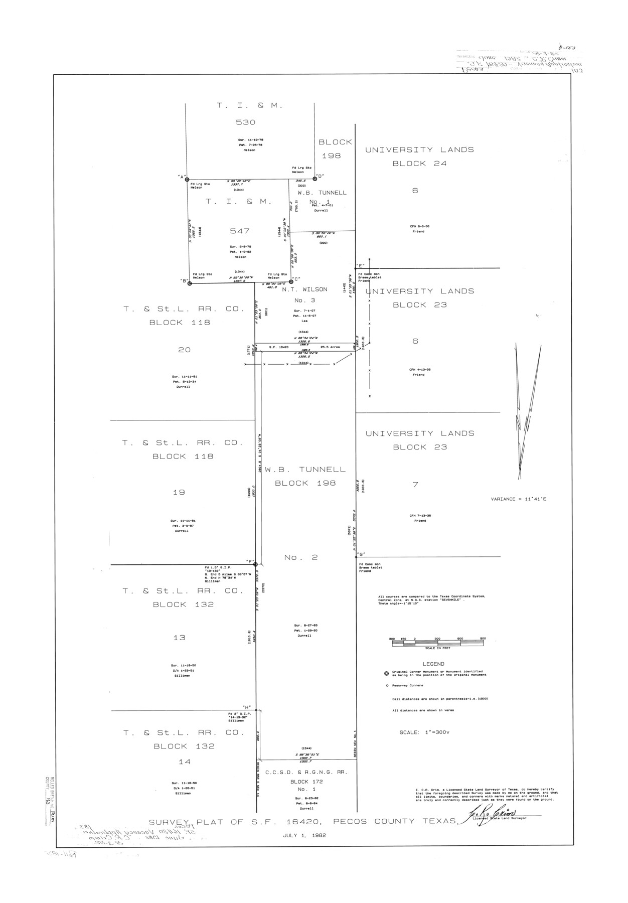
Pecos County Rolled Sketch 183
Survey plat of SF-16420, Pecos County, Texas
-
Map/Doc
7302
-
Collection
General Map Collection
-
Object Dates
1982/7/1 (Creation Date)
1982/8/3 (File Date)
-
People and Organizations
C.R. Crim (Surveyor/Engineer)
-
Counties
Pecos
-
Subjects
Surveying Rolled Sketch
-
Height x Width
39.6 x 27.5 inches
100.6 x 69.9 cm
-
Medium
mylar, print
-
Scale
1" = 300 varas
Part of: General Map Collection
Jefferson County Working Sketch 8

Print $20.00
- Digital $50.00
Jefferson County Working Sketch 8
1931
Size 34.9 x 18.2 inches
Map/Doc 66551
Travis County Sketch File XYZ

Print $4.00
- Digital $50.00
Travis County Sketch File XYZ
Size 10.1 x 8.3 inches
Map/Doc 38352
Val Verde County Working Sketch 14

Print $20.00
- Digital $50.00
Val Verde County Working Sketch 14
1926
Size 17.2 x 18.9 inches
Map/Doc 72149
Hutchinson County Rolled Sketch 43

Print $40.00
- Digital $50.00
Hutchinson County Rolled Sketch 43
1992
Size 41.3 x 50.0 inches
Map/Doc 6314
Oldham County Sketch File 10

Print $8.00
- Digital $50.00
Oldham County Sketch File 10
Size 12.7 x 8.3 inches
Map/Doc 33243
Brewster County Working Sketch 50

Print $40.00
- Digital $50.00
Brewster County Working Sketch 50
1950
Size 31.5 x 48.4 inches
Map/Doc 67584
Young County Rolled Sketch 2

Print $20.00
- Digital $50.00
Young County Rolled Sketch 2
Size 26.2 x 25.0 inches
Map/Doc 8292
Karte vom Jagd-Cebiet der Komantschen in Texas

Print $20.00
- Digital $50.00
Karte vom Jagd-Cebiet der Komantschen in Texas
1851
Size 11.0 x 8.8 inches
Map/Doc 97519
King County Working Sketch 18-0

Print $40.00
- Digital $50.00
King County Working Sketch 18-0
Size 44.0 x 56.5 inches
Map/Doc 78212
Map of Galveston County

Print $20.00
- Digital $50.00
Map of Galveston County
1883
Size 18.8 x 26.8 inches
Map/Doc 3573
Flight Mission No. DQN-2K, Frame 65, Calhoun County

Print $20.00
- Digital $50.00
Flight Mission No. DQN-2K, Frame 65, Calhoun County
1953
Size 18.5 x 22.2 inches
Map/Doc 84257
Flight Mission No. DAG-19K, Frame 66, Matagorda County

Print $20.00
- Digital $50.00
Flight Mission No. DAG-19K, Frame 66, Matagorda County
1952
Size 16.3 x 16.3 inches
Map/Doc 86393
You may also like

Austin, Texas - Congress Ave. Drainage

Print $20.00
- Digital $50.00
Austin, Texas - Congress Ave. Drainage
1905
Size 15.8 x 31.2 inches
Map/Doc 458
Map of Fort Stockton

Print $20.00
- Digital $50.00
Map of Fort Stockton
Size 22.4 x 18.3 inches
Map/Doc 76870
Amistad International Reservoir on Rio Grande 65

Print $20.00
- Digital $50.00
Amistad International Reservoir on Rio Grande 65
1949
Size 28.2 x 39.8 inches
Map/Doc 73350
Gray County Working Sketch 5

Print $20.00
- Digital $50.00
Gray County Working Sketch 5
1959
Size 28.6 x 27.5 inches
Map/Doc 63236
San Jacinto County Rolled Sketch 14

Print $20.00
- Digital $50.00
San Jacinto County Rolled Sketch 14
1998
Size 26.5 x 37.3 inches
Map/Doc 7568
Crockett County Rolled Sketch 59

Print $20.00
- Digital $50.00
Crockett County Rolled Sketch 59
1946
Size 30.1 x 20.9 inches
Map/Doc 5602
Hays County Rolled Sketch 32

Print $20.00
- Digital $50.00
Hays County Rolled Sketch 32
2003
Size 15.6 x 20.0 inches
Map/Doc 78489
United States - Gulf Coast - Galveston to Rio Grande

Print $20.00
- Digital $50.00
United States - Gulf Coast - Galveston to Rio Grande
1919
Size 27.1 x 18.3 inches
Map/Doc 72745
Hardin County Sketch File 32

Print $8.00
- Digital $50.00
Hardin County Sketch File 32
Size 12.9 x 8.3 inches
Map/Doc 25163
San Patricio County Working Sketch 12

Print $40.00
- Digital $50.00
San Patricio County Working Sketch 12
Size 51.4 x 40.7 inches
Map/Doc 63774
