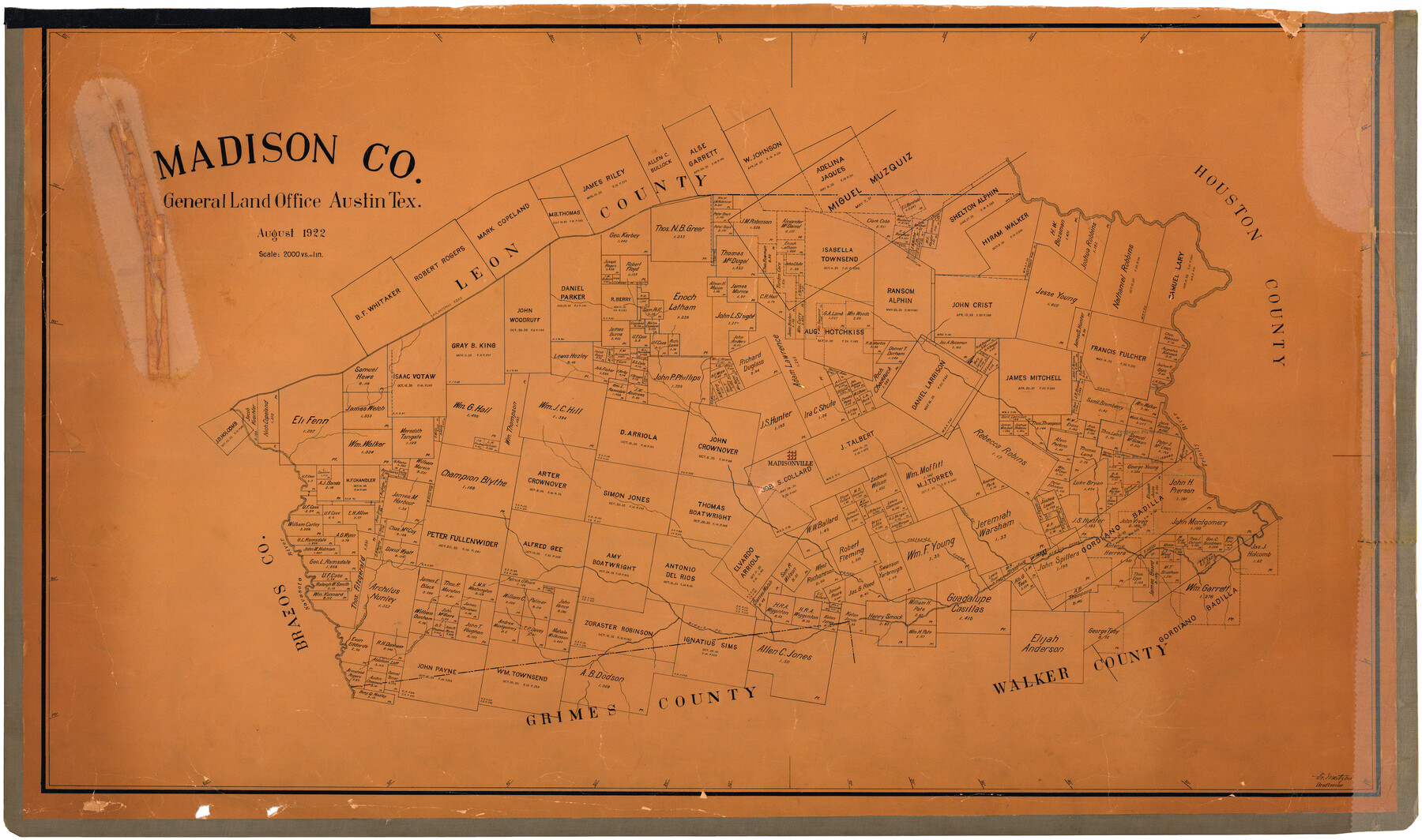
Madison Co.
- 
                          Map/Doc
73228
 - 
                            Collection
General Map Collection
 - 
                            Object Dates
1922 (Creation Date)
 - 
                            People and Organizations
Texas General Land Office (Publisher)
Fr. Matzow (Draftsman)
 - 
                            Counties
Madison
 - 
                            Subjects
County
 - 
                            Height x Width
28.7 x 48.4 inches
72.9 x 122.9 cm
 - 
                            Comments
Hand lettered.
 - 
                            Features
San Antonio Road
Trinity River
Madisonville
Navasota River
Collards Creek
Pools Creek
Caney Creek
Shepherds Creek
Prewitts Creek
Bidais Creek
 
Part of: General Map Collection
            Rio Grande Rectification Project, El Paso and Juarez Valley


                                            Print $3.00                    
                                             -                         Digital $50.00                                    
                Rio Grande Rectification Project, El Paso and Juarez Valley
1935
Size 9.7 x 14.9 inches
                                Map/Doc 1749
            
            Carta Esferica que comprehende las costas del Seno Mexicano construida de orden del rey en el deposito hidrografico de marina:  Por disposicion del Exmo. Señor Don Juan de Langara, Secretario de Estado y del Despacho Universal de ella. Año de 1799.


                                            Print $20.00                    
                                             -                         Digital $50.00                                    
                Carta Esferica que comprehende las costas del Seno Mexicano construida de orden del rey en el deposito hidrografico de marina: Por disposicion del Exmo. Señor Don Juan de Langara, Secretario de Estado y del Despacho Universal de ella. Año de 1799.
1799
Size 25.9 x 37.3 inches
                                Map/Doc 95367
            
            Clay County Sketch File 9


                                            Print $6.00                    
                                             -                         Digital $50.00                                    
                Clay County Sketch File 9
1860
Size 8.4 x 7.6 inches
                                Map/Doc 18400
            
            Eastland County Working Sketch Graphic Index


                                            Print $20.00                    
                                             -                         Digital $50.00                                    
                Eastland County Working Sketch Graphic Index
1945
Size 41.6 x 42.4 inches
                                Map/Doc 76529
            
            Galveston County NRC Article 33.136 Sketch 53


                                            Print $24.00                    
                                             -                         Digital $50.00                                    
                Galveston County NRC Article 33.136 Sketch 53
2009
Size 22.3 x 34.0 inches
                                Map/Doc 94609
            
            Tom Green County Sketch File 73


                                            Print $12.00                    
                                             -                         Digital $50.00                                    
                Tom Green County Sketch File 73
1949
Size 11.2 x 8.8 inches
                                Map/Doc 38244
            
            Map of the Lands Surveyed by the Memphis, El Paso & Pacific R.R. Company


                                            Print $20.00                    
                                             -                         Digital $50.00                                    
                Map of the Lands Surveyed by the Memphis, El Paso & Pacific R.R. Company
1859
Size 15.0 x 30.0 inches
                                Map/Doc 2219
            
            Tom Green County


                                            Print $40.00                    
                                             -                         Digital $50.00                                    
                Tom Green County
Size 43.6 x 111.2 inches
                                Map/Doc 82058
            
            Liberty County Working Sketch 28


                                            Print $20.00                    
                                             -                         Digital $50.00                                    
                Liberty County Working Sketch 28
1942
Size 22.4 x 23.2 inches
                                Map/Doc 70487
            
            Wilson County Working Sketch 10


                                            Print $20.00                    
                                             -                         Digital $50.00                                    
                Wilson County Working Sketch 10
1980
Size 16.6 x 11.7 inches
                                Map/Doc 72590
            
            Galveston Bay, Texas


                                            Print $20.00                    
                                             -                         Digital $50.00                                    
                Galveston Bay, Texas
1905
Size 24.8 x 18.5 inches
                                Map/Doc 65390
            You may also like
            Flight Mission No. BQR-4K, Frame 70, Brazoria County


                                            Print $20.00                    
                                             -                         Digital $50.00                                    
                Flight Mission No. BQR-4K, Frame 70, Brazoria County
1952
Size 18.8 x 22.4 inches
                                Map/Doc 84003
            
            Flight Mission No. CUG-2P, Frame 70, Kleberg County


                                            Print $20.00                    
                                             -                         Digital $50.00                                    
                Flight Mission No. CUG-2P, Frame 70, Kleberg County
1956
Size 18.7 x 22.4 inches
                                Map/Doc 86207
            
            Bobalet Heights


                                            Print $20.00                    
                                             -                         Digital $50.00                                    
                Bobalet Heights
1941
Size 35.6 x 36.5 inches
                                Map/Doc 92787
            
            [Map of California and Nevada]


                                            Print $20.00                    
                                             -                         Digital $50.00                                    
                [Map of California and Nevada]
1869
Size 9.1 x 10.6 inches
                                Map/Doc 96620
            
            Flight Mission No. DAG-21K, Frame 130, Matagorda County


                                            Print $20.00                    
                                             -                         Digital $50.00                                    
                Flight Mission No. DAG-21K, Frame 130, Matagorda County
1952
Size 18.5 x 22.4 inches
                                Map/Doc 86456
            
            Runnels County Rolled Sketch 30


                                            Print $20.00                    
                                             -                         Digital $50.00                                    
                Runnels County Rolled Sketch 30
Size 26.8 x 30.6 inches
                                Map/Doc 7518
            
            Milam County Working Sketch 9


                                            Print $20.00                    
                                             -                         Digital $50.00                                    
                Milam County Working Sketch 9
1976
Size 27.2 x 22.7 inches
                                Map/Doc 71024
            
            Angelina County Working Sketch 55


                                            Print $20.00                    
                                             -                         Digital $50.00                                    
                Angelina County Working Sketch 55
1989
Size 33.7 x 30.0 inches
                                Map/Doc 67139
            
            Aransas County Sketch File 21b


                                            Print $4.00                    
                                             -                         Digital $50.00                                    
                Aransas County Sketch File 21b
Size 8.7 x 14.2 inches
                                Map/Doc 13160
            
            Bexar County Rolled Sketch 16


                                            Print $20.00                    
                                             -                         Digital $50.00                                    
                Bexar County Rolled Sketch 16
1847
Size 21.1 x 14.8 inches
                                Map/Doc 5141
            
            Webb County Working Sketch Graphic Index - south part


                                            Print $40.00                    
                                             -                         Digital $50.00                                    
                Webb County Working Sketch Graphic Index - south part
1984
Size 43.4 x 62.9 inches
                                Map/Doc 76735
            
            Galveston County Rolled Sketch 34


                                            Print $20.00                    
                                             -                         Digital $50.00                                    
                Galveston County Rolled Sketch 34
1979
Size 28.0 x 39.7 inches
                                Map/Doc 5966