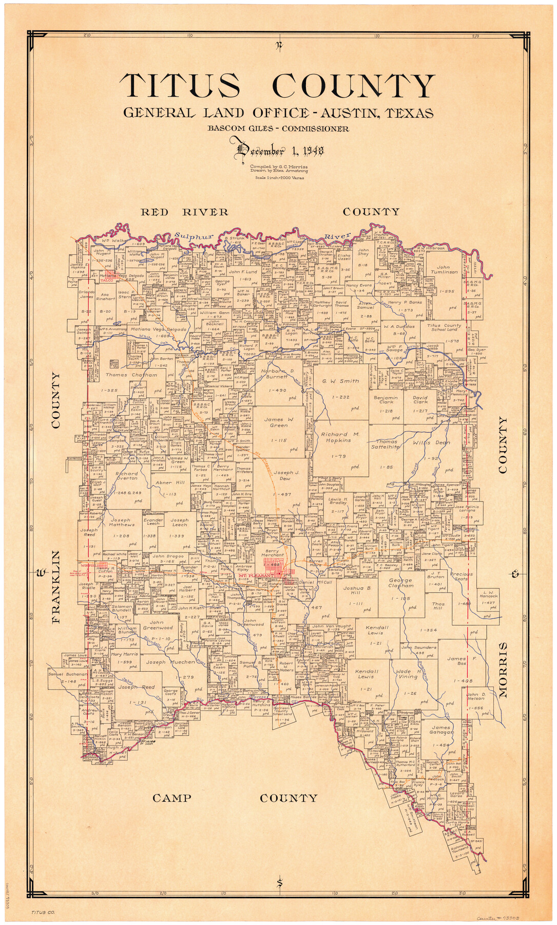
Titus County
-
Map/Doc
73303
-
Collection
General Map Collection
-
Object Dates
1948/12/1 (Creation Date)
-
People and Organizations
Texas General Land Office (Publisher)
Eltea Armstrong (Draftsman)
Bascom Giles (GLO Commissioner)
G.C. Morriss (Compiler)
-
Counties
Titus
-
Subjects
County
-
Height x Width
41.2 x 25.0 inches
104.6 x 63.5 cm
-
Comments
Hand lettered.
-
Features
Ripleys Creek
Sulpher River
LA&T
Swanano Creek
Big Cypress Creek
Jakes Creek
Blundells Creek
Short Creek
Tankersleys Creek
Harts Creek
Winfield
Mount Pleasant
SL&S
Long Lake
Buck Creek
Horse Creek
P&MP
Mill Creek
Pine Creek
Turkey Creek
White Oak Bayou
White Oak Creek
Talco
Lacys Creek
Sulphur Fork of Red River
Part of: General Map Collection
Bandera County Boundary File 4

Print $18.00
- Digital $50.00
Bandera County Boundary File 4
Size 8.9 x 7.7 inches
Map/Doc 50267
El Paso County Boundary File 9

Print $14.00
- Digital $50.00
El Paso County Boundary File 9
Size 12.7 x 8.2 inches
Map/Doc 53111
Brewster County Sketch File N-20

Print $40.00
- Digital $50.00
Brewster County Sketch File N-20
1941
Size 16.5 x 20.5 inches
Map/Doc 10967
Coke County Sketch File 19

Print $20.00
- Digital $50.00
Coke County Sketch File 19
Size 18.5 x 25.0 inches
Map/Doc 11110
Hutchinson County Sketch File 35

Print $6.00
- Digital $50.00
Hutchinson County Sketch File 35
1935
Size 11.2 x 8.9 inches
Map/Doc 27267
Map No. 1 - Rio Bravo del Norte section of boundary between the United States & Mexico agreed upon by the Joint Commission under the Treaty of Guadalupe Hidalgo

Print $20.00
- Digital $50.00
Map No. 1 - Rio Bravo del Norte section of boundary between the United States & Mexico agreed upon by the Joint Commission under the Treaty of Guadalupe Hidalgo
1852
Size 18.4 x 27.0 inches
Map/Doc 72864
Railroad Track Map, T&PRRCo., Culberson County, Texas

Print $4.00
- Digital $50.00
Railroad Track Map, T&PRRCo., Culberson County, Texas
1910
Size 11.7 x 18.5 inches
Map/Doc 62825
Red River County Sketch File A

Print $40.00
- Digital $50.00
Red River County Sketch File A
1900
Size 20.1 x 23.8 inches
Map/Doc 12236
Hutchinson County Working Sketch 1

Print $3.00
- Digital $50.00
Hutchinson County Working Sketch 1
Size 9.5 x 17.0 inches
Map/Doc 66359
Van Zandt County Sketch File 20a

Print $4.00
- Digital $50.00
Van Zandt County Sketch File 20a
1858
Size 12.9 x 8.0 inches
Map/Doc 39428
Gaines County Rolled Sketch 15A

Print $40.00
- Digital $50.00
Gaines County Rolled Sketch 15A
Size 90.5 x 23.8 inches
Map/Doc 9036
Anderson County Sketch File 3

Print $4.00
- Digital $50.00
Anderson County Sketch File 3
1856
Size 12.7 x 8.2 inches
Map/Doc 12741
You may also like
Land Grant Map of Comal County

Print $20.00
- Digital $50.00
Land Grant Map of Comal County
2006
Size 33.3 x 41.0 inches
Map/Doc 83601
Crosby County Sketch File 9

Print $8.00
- Digital $50.00
Crosby County Sketch File 9
1887
Size 9.1 x 7.9 inches
Map/Doc 20007
[T. & P. Block 44, Township 2S]
![90949, [T. & P. Block 44, Township 2S], Twichell Survey Records](https://historictexasmaps.com/wmedia_w700/maps/90949-1.tif.jpg)
Print $20.00
- Digital $50.00
[T. & P. Block 44, Township 2S]
Size 10.0 x 21.9 inches
Map/Doc 90949
Orange County Sketch File 23

Print $36.00
- Digital $50.00
Orange County Sketch File 23
1911
Size 9.2 x 5.9 inches
Map/Doc 33344
General Highway Map. Detail of Cities and Towns in Potter County, Texas [Amarillo and vicinity]
![79221, General Highway Map. Detail of Cities and Towns in Potter County, Texas [Amarillo and vicinity], Texas State Library and Archives](https://historictexasmaps.com/wmedia_w700/maps/79221.tif.jpg)
Print $20.00
General Highway Map. Detail of Cities and Towns in Potter County, Texas [Amarillo and vicinity]
1940
Size 24.6 x 18.2 inches
Map/Doc 79221
Crockett County Sketch File D

Print $40.00
- Digital $50.00
Crockett County Sketch File D
1903
Size 24.6 x 48.0 inches
Map/Doc 10347
Denton County Working Sketch 8

Print $20.00
- Digital $50.00
Denton County Working Sketch 8
1959
Size 37.4 x 30.8 inches
Map/Doc 68613
Laneer vs. Bivins, Potter County, Texas

Print $20.00
- Digital $50.00
Laneer vs. Bivins, Potter County, Texas
Size 21.2 x 19.0 inches
Map/Doc 93101
Ector County Working Sketch 24

Print $40.00
- Digital $50.00
Ector County Working Sketch 24
1961
Size 42.2 x 51.7 inches
Map/Doc 68867
Current Miscellaneous File 33

Print $6.00
- Digital $50.00
Current Miscellaneous File 33
1953
Size 10.8 x 8.2 inches
Map/Doc 73939
Map of the Harlem State Farm and the Central State Farm, Fort Bend County, Texas

Print $20.00
- Digital $50.00
Map of the Harlem State Farm and the Central State Farm, Fort Bend County, Texas
Size 35.7 x 32.1 inches
Map/Doc 62995
[E. L. & R. R. RR. Co. Block D8 and vicinity]
![91863, [E. L. & R. R. RR. Co. Block D8 and vicinity], Twichell Survey Records](https://historictexasmaps.com/wmedia_w700/maps/91863-1.tif.jpg)
Print $20.00
- Digital $50.00
[E. L. & R. R. RR. Co. Block D8 and vicinity]
1891
Size 18.5 x 21.0 inches
Map/Doc 91863