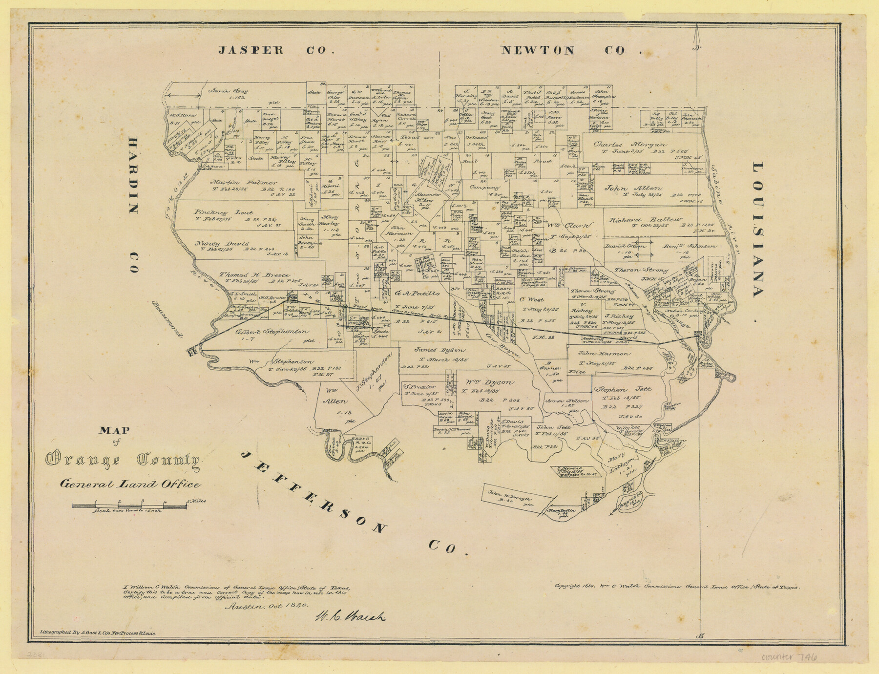
Map of Orange County, Texas
-
Map/Doc
746
-
Collection
Maddox Collection
-
Object Dates
1880 (Creation Date)
-
People and Organizations
General Land Office (Publisher)
W.C. Walsh (GLO Commissioner)
August Gast & Co. (Lithographer)
-
Counties
Orange
-
Subjects
County
-
Height x Width
15.6 x 19.1 inches
39.6 x 48.5 cm
-
Medium
paper, etching/engraving/lithograph
-
Scale
1" = 4000 varas
-
Comments
Conservation funded in 2011.
-
Features
Walnut Creek
Sabine River
Neches River
Adams Bayou
Cypress Bayou
Orange
Cow Bayou
T&NO
Beaumont
Part of: Maddox Collection
[Highway Map of the State of Texas]
![5039, [Highway Map of the State of Texas], Maddox Collection](https://historictexasmaps.com/wmedia_w700/maps/5039-1.tif.jpg)
Print $20.00
- Digital $50.00
[Highway Map of the State of Texas]
1923
Size 44.7 x 46.7 inches
Map/Doc 5039
Hemphill County, Texas

Print $20.00
- Digital $50.00
Hemphill County, Texas
1880
Size 19.7 x 18.6 inches
Map/Doc 549
Map of survey 189, T. C. R.R. Co. in Travis County, Texas

Print $20.00
- Digital $50.00
Map of survey 189, T. C. R.R. Co. in Travis County, Texas
1915
Size 18.6 x 15.2 inches
Map/Doc 78479
Map of the San Antonio del Encinal as Corrected

Print $20.00
- Digital $50.00
Map of the San Antonio del Encinal as Corrected
1916
Size 28.5 x 30.6 inches
Map/Doc 4456
Capitol Land Reservation

Print $40.00
- Digital $50.00
Capitol Land Reservation
1882
Size 51.4 x 18.0 inches
Map/Doc 76175
Callahan County, Texas

Print $20.00
- Digital $50.00
Callahan County, Texas
1880
Size 24.1 x 18.4 inches
Map/Doc 681
[Surveying Sketch of T. & N. O. R. R. Co., S. P. R. R. Co., E. T. R. R. Co., et al in Dallam, Hartley, Sherman & Moore Counties, Texas]
![75824, [Surveying Sketch of T. & N. O. R. R. Co., S. P. R. R. Co., E. T. R. R. Co., et al in Dallam, Hartley, Sherman & Moore Counties, Texas], Maddox Collection](https://historictexasmaps.com/wmedia_w700/maps/75824.tif.jpg)
Print $20.00
- Digital $50.00
[Surveying Sketch of T. & N. O. R. R. Co., S. P. R. R. Co., E. T. R. R. Co., et al in Dallam, Hartley, Sherman & Moore Counties, Texas]
Size 17.5 x 22.1 inches
Map/Doc 75824
Map of Frio County, Texas

Print $20.00
- Digital $50.00
Map of Frio County, Texas
1879
Size 22.8 x 21.9 inches
Map/Doc 545
Tarrant County, Texas

Print $20.00
- Digital $50.00
Tarrant County, Texas
1870
Size 24.1 x 19.1 inches
Map/Doc 758
[Sketch of Surveys Near Port Aransas and Aransas Pass, Aransas County, Texas]
![676, [Sketch of Surveys Near Port Aransas and Aransas Pass, Aransas County, Texas], Maddox Collection](https://historictexasmaps.com/wmedia_w700/maps/676.tif.jpg)
Print $20.00
- Digital $50.00
[Sketch of Surveys Near Port Aransas and Aransas Pass, Aransas County, Texas]
Size 22.8 x 18.5 inches
Map/Doc 676
[Map of Zalsamora Pasture and surrounding area]
![408, [Map of Zalsamora Pasture and surrounding area], Maddox Collection](https://historictexasmaps.com/wmedia_w700/maps/408.tif.jpg)
Print $20.00
- Digital $50.00
[Map of Zalsamora Pasture and surrounding area]
Size 33.3 x 24.4 inches
Map/Doc 408
Map of Falls County, Texas

Print $20.00
- Digital $50.00
Map of Falls County, Texas
1879
Size 19.4 x 23.0 inches
Map/Doc 724
You may also like
Val Verde County Working Sketch 41

Print $20.00
- Digital $50.00
Val Verde County Working Sketch 41
1943
Size 27.8 x 30.2 inches
Map/Doc 72176
Webb County Working Sketch 74

Print $20.00
- Digital $50.00
Webb County Working Sketch 74
1975
Size 17.0 x 30.0 inches
Map/Doc 72441
Hunt County Sketch File 16a

Print $4.00
- Digital $50.00
Hunt County Sketch File 16a
Size 4.6 x 8.1 inches
Map/Doc 27109
Flight Mission No. DAG-24K, Frame 139, Matagorda County

Print $20.00
- Digital $50.00
Flight Mission No. DAG-24K, Frame 139, Matagorda County
1953
Size 18.5 x 22.3 inches
Map/Doc 86557
Cooke County Sketch File 9

Print $6.00
- Digital $50.00
Cooke County Sketch File 9
Size 8.2 x 10.5 inches
Map/Doc 19237
Nueces County Sketch File 31

Print $8.00
- Digital $50.00
Nueces County Sketch File 31
1907
Size 14.1 x 8.6 inches
Map/Doc 32601
No. 3 Chart of Channel connecting Corpus Christi Bay with Aransas Bay, Texas

Print $20.00
- Digital $50.00
No. 3 Chart of Channel connecting Corpus Christi Bay with Aransas Bay, Texas
1878
Size 18.1 x 27.8 inches
Map/Doc 72780
Louisiana and Texas Intracoastal Waterway - High Island to Port Bolivar Dredging - Sheet 5

Print $20.00
- Digital $50.00
Louisiana and Texas Intracoastal Waterway - High Island to Port Bolivar Dredging - Sheet 5
1943
Size 31.4 x 41.8 inches
Map/Doc 61824
Corpus Christi Bay

Print $20.00
- Digital $50.00
Corpus Christi Bay
1976
Size 36.2 x 47.8 inches
Map/Doc 73476
Coke County Rolled Sketch 25

Print $20.00
- Digital $50.00
Coke County Rolled Sketch 25
1974
Size 24.9 x 24.3 inches
Map/Doc 5525
Tyler County Working Sketch 21

Print $20.00
- Digital $50.00
Tyler County Working Sketch 21
1985
Size 21.1 x 21.0 inches
Map/Doc 69491
Panola County Working Sketch 37

Print $20.00
- Digital $50.00
Panola County Working Sketch 37
1984
Map/Doc 71446