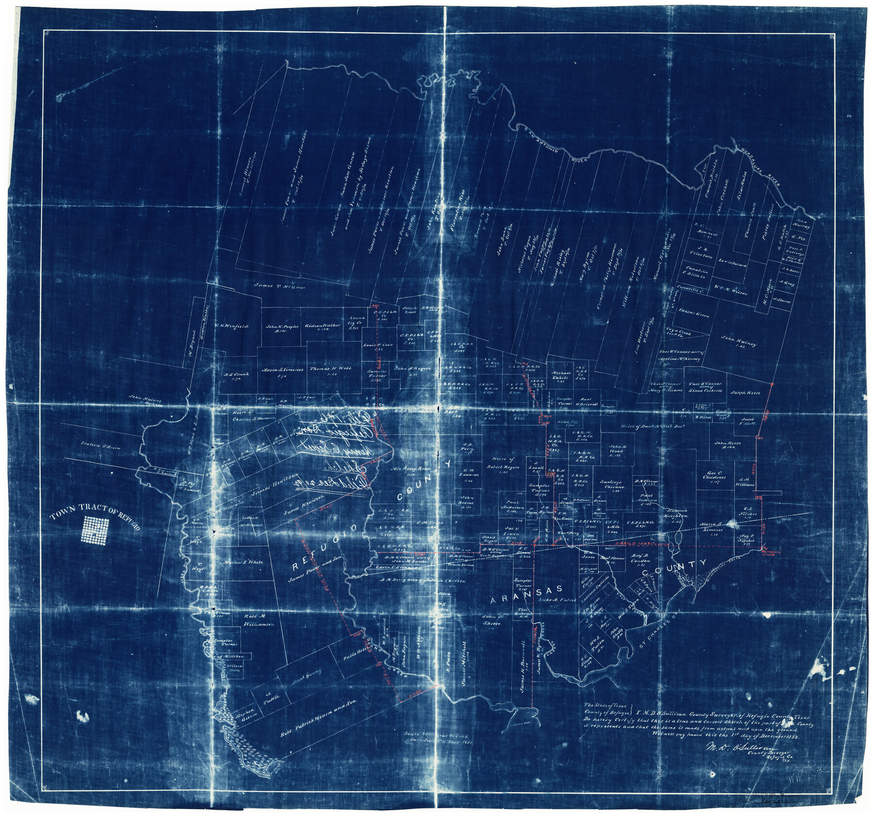
Refugio County Rolled Sketch 6
[Map of Refugio and Aransas Counties]
-
Map/Doc
7506
-
Collection
General Map Collection
-
Object Dates
12/1/1892 (Creation Date)
2/20/1943 (File Date)
-
People and Organizations
M.D. O'Sullivan (Surveyor/Engineer)
-
Counties
Refugio Aransas
-
Subjects
Surveying Rolled Sketch
-
Height x Width
29.1 x 30.6 inches
73.9 x 77.7 cm
-
Medium
blueprint/diazo
-
Scale
1" = 2000 varas
Part of: General Map Collection
A plat representing the survey and resubdivision of four tracts of land known as tracts no. 27, no. 26, no. 23, and no. 22, all of which are part of the Tara Subdivision, an unrecorded subdivision of 263.28 acres out of the J. M. Speer Subdivision

Print $6.00
- Digital $50.00
A plat representing the survey and resubdivision of four tracts of land known as tracts no. 27, no. 26, no. 23, and no. 22, all of which are part of the Tara Subdivision, an unrecorded subdivision of 263.28 acres out of the J. M. Speer Subdivision
1991
Size 24.7 x 34.3 inches
Map/Doc 3112
Flight Mission No. CRC-5R, Frame 24, Chambers County

Print $20.00
- Digital $50.00
Flight Mission No. CRC-5R, Frame 24, Chambers County
1956
Size 18.7 x 22.4 inches
Map/Doc 84946
Dawson County Sketch File 8

Print $12.00
- Digital $50.00
Dawson County Sketch File 8
1924
Size 11.3 x 9.0 inches
Map/Doc 20536
Atascosa County Sketch File 27c

Print $12.00
- Digital $50.00
Atascosa County Sketch File 27c
1876
Size 12.7 x 8.4 inches
Map/Doc 13806
Flight Mission No. CUG-3P, Frame 18, Kleberg County

Print $20.00
- Digital $50.00
Flight Mission No. CUG-3P, Frame 18, Kleberg County
1956
Size 18.5 x 22.3 inches
Map/Doc 86228
Terry County Rolled Sketch 6

Print $20.00
- Digital $50.00
Terry County Rolled Sketch 6
1944
Size 36.5 x 43.7 inches
Map/Doc 9996
Flight Mission No. CGI-1N, Frame 140, Cameron County

Print $20.00
- Digital $50.00
Flight Mission No. CGI-1N, Frame 140, Cameron County
1955
Size 18.7 x 22.3 inches
Map/Doc 84496
Hardin County Working Sketch 19

Print $20.00
- Digital $50.00
Hardin County Working Sketch 19
1947
Size 28.9 x 34.3 inches
Map/Doc 63417
Part of Harris County

Print $20.00
- Digital $50.00
Part of Harris County
1876
Size 24.5 x 35.3 inches
Map/Doc 1479
Randall County Boundary File 3

Print $8.00
- Digital $50.00
Randall County Boundary File 3
Size 14.3 x 8.8 inches
Map/Doc 58125
McMullen County Sketch File 16

Print $24.00
- Digital $50.00
McMullen County Sketch File 16
1876
Size 5.3 x 8.3 inches
Map/Doc 31365
Marion County

Print $20.00
- Digital $50.00
Marion County
1943
Size 30.3 x 47.9 inches
Map/Doc 95579
You may also like
General Highway Map, Webb County, Texas

Print $20.00
General Highway Map, Webb County, Texas
1961
Size 18.2 x 24.8 inches
Map/Doc 79704
Starr County Sketch File 22

Print $20.00
- Digital $50.00
Starr County Sketch File 22
1922
Size 16.4 x 35.9 inches
Map/Doc 12331
Original Town of Nadine, Lea County, New Mexico

Print $20.00
- Digital $50.00
Original Town of Nadine, Lea County, New Mexico
Size 27.1 x 33.5 inches
Map/Doc 92420
Flight Mission No. BRA-7M, Frame 184, Jefferson County

Print $20.00
- Digital $50.00
Flight Mission No. BRA-7M, Frame 184, Jefferson County
1953
Size 18.6 x 22.3 inches
Map/Doc 85552
Fort Bend County Rolled Sketch T

Print $20.00
- Digital $50.00
Fort Bend County Rolled Sketch T
1930
Size 28.7 x 25.8 inches
Map/Doc 5908
[East half of Crockett County]
![92997, [East half of Crockett County], Twichell Survey Records](https://historictexasmaps.com/wmedia_w700/maps/92997-1.tif.jpg)
Print $20.00
- Digital $50.00
[East half of Crockett County]
Size 15.2 x 21.9 inches
Map/Doc 92997
Fort Bend County Working Sketch 32

Print $20.00
- Digital $50.00
Fort Bend County Working Sketch 32
2000
Size 36.5 x 42.5 inches
Map/Doc 69238
El Paso County Rolled Sketch 40

Print $20.00
- Digital $50.00
El Paso County Rolled Sketch 40
1929
Size 43.6 x 25.2 inches
Map/Doc 5827
Terrell County Working Sketch 26

Print $20.00
- Digital $50.00
Terrell County Working Sketch 26
1943
Size 17.5 x 14.0 inches
Map/Doc 62176
Cottle County Working Sketch 19

Print $20.00
- Digital $50.00
Cottle County Working Sketch 19
1978
Size 33.2 x 29.3 inches
Map/Doc 68329
Wilson County Sketch File 8

Print $8.00
- Digital $50.00
Wilson County Sketch File 8
1879
Size 10.4 x 8.2 inches
Map/Doc 40413
Dawson County Working Sketch 2

Print $20.00
- Digital $50.00
Dawson County Working Sketch 2
1937
Size 8.8 x 20.3 inches
Map/Doc 68546