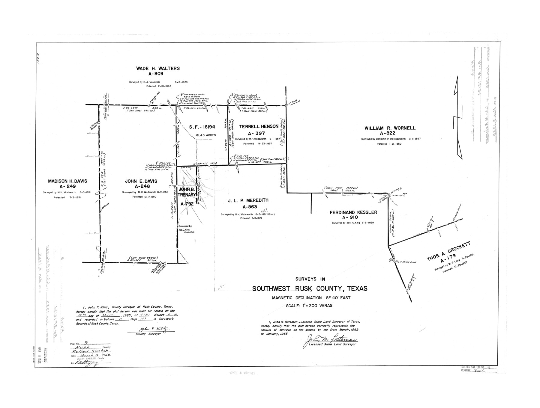
Rusk County Rolled Sketch 9
Surveys in southwest Rusk County, Texas
-
Map/Doc
7546
-
Collection
General Map Collection
-
Object Dates
1965 (Survey Date)
1965/3/9 (File Date)
-
People and Organizations
John M. Bateman (Surveyor/Engineer)
-
Counties
Rusk
-
Subjects
Surveying Rolled Sketch
-
Height x Width
25.0 x 33.0 inches
63.5 x 83.8 cm
-
Scale
1" = 200 varas
Part of: General Map Collection

Township No. 5 South Range No. 11 West of the Indian Meridian

Print $20.00
- Digital $50.00
Township No. 5 South Range No. 11 West of the Indian Meridian
1875
Size 19.3 x 24.3 inches
Map/Doc 75160
Haskell County Sketch File 15a

Print $4.00
- Digital $50.00
Haskell County Sketch File 15a
Size 9.8 x 8.6 inches
Map/Doc 26161
Blanco County Boundary File 5

Print $100.00
- Digital $50.00
Blanco County Boundary File 5
Size 17.1 x 14.1 inches
Map/Doc 50555
Flight Mission No. CUG-2P, Frame 70, Kleberg County

Print $20.00
- Digital $50.00
Flight Mission No. CUG-2P, Frame 70, Kleberg County
1956
Size 18.7 x 22.4 inches
Map/Doc 86207
Map of Lands surveyed for the Deaf & Dumb Asylum on the head waters of the Leon River

Print $20.00
- Digital $50.00
Map of Lands surveyed for the Deaf & Dumb Asylum on the head waters of the Leon River
1857
Size 13.3 x 17.1 inches
Map/Doc 2209
Lamar County Working Sketch 7

Print $20.00
- Digital $50.00
Lamar County Working Sketch 7
1964
Size 18.7 x 17.6 inches
Map/Doc 70268
Bowie County Working Sketch 1

Print $20.00
- Digital $50.00
Bowie County Working Sketch 1
Size 16.7 x 12.1 inches
Map/Doc 67405
Crane County Sketch File 6

Print $20.00
- Digital $50.00
Crane County Sketch File 6
Size 18.7 x 22.8 inches
Map/Doc 11207
Hansford County Working Sketch 9

Print $20.00
- Digital $50.00
Hansford County Working Sketch 9
1984
Size 31.5 x 38.2 inches
Map/Doc 63381
El Paso County Rolled Sketch 49

Print $40.00
- Digital $50.00
El Paso County Rolled Sketch 49
Size 10.5 x 99.9 inches
Map/Doc 8875
United States - Gulf Coast - Padre I. and Laguna Madre Lat. 27° 12' to Lat. 26° 33' Texas

Print $20.00
- Digital $50.00
United States - Gulf Coast - Padre I. and Laguna Madre Lat. 27° 12' to Lat. 26° 33' Texas
1913
Size 26.9 x 18.2 inches
Map/Doc 72820
You may also like
Maverick County Working Sketch 13

Print $20.00
- Digital $50.00
Maverick County Working Sketch 13
1969
Size 27.3 x 35.8 inches
Map/Doc 70905
Township No. 5 South Range No. 15 West, Indian Meridian, Oklahoma

Print $4.00
- Digital $50.00
Township No. 5 South Range No. 15 West, Indian Meridian, Oklahoma
1927
Size 18.2 x 23.9 inches
Map/Doc 75136
Flight Mission No. CRC-2R, Frame 186, Chambers County

Print $20.00
- Digital $50.00
Flight Mission No. CRC-2R, Frame 186, Chambers County
1956
Size 18.7 x 22.4 inches
Map/Doc 84764
Reeves County

Print $40.00
- Digital $50.00
Reeves County
1915
Size 48.4 x 38.7 inches
Map/Doc 66999
Kimble County Sketch File 2

Print $2.00
- Digital $50.00
Kimble County Sketch File 2
Size 7.0 x 6.7 inches
Map/Doc 28909
Kimble County Working Sketch 60

Print $20.00
- Digital $50.00
Kimble County Working Sketch 60
1964
Size 43.8 x 38.2 inches
Map/Doc 70128

San Antonio del Encinal as Corrected

Print $20.00
- Digital $50.00
San Antonio del Encinal as Corrected
1916
Size 31.2 x 31.5 inches
Map/Doc 10757
Foard County Rolled Sketch 15

Print $20.00
- Digital $50.00
Foard County Rolled Sketch 15
1889
Size 19.9 x 38.3 inches
Map/Doc 5890
Newton County Working Sketch 32

Print $20.00
- Digital $50.00
Newton County Working Sketch 32
1955
Size 22.9 x 24.0 inches
Map/Doc 71278
Flight Mission No. DIX-3P, Frame 173, Aransas County

Print $20.00
- Digital $50.00
Flight Mission No. DIX-3P, Frame 173, Aransas County
1956
Size 17.8 x 17.9 inches
Map/Doc 83779
[Townships 1 & 2, Blocks 53, 54 & 55]
![92952, [Townships 1 & 2, Blocks 53, 54 & 55], Twichell Survey Records](https://historictexasmaps.com/wmedia_w700/maps/92952-1.tif.jpg)
Print $20.00
- Digital $50.00
[Townships 1 & 2, Blocks 53, 54 & 55]
Size 34.3 x 20.0 inches
Map/Doc 92952