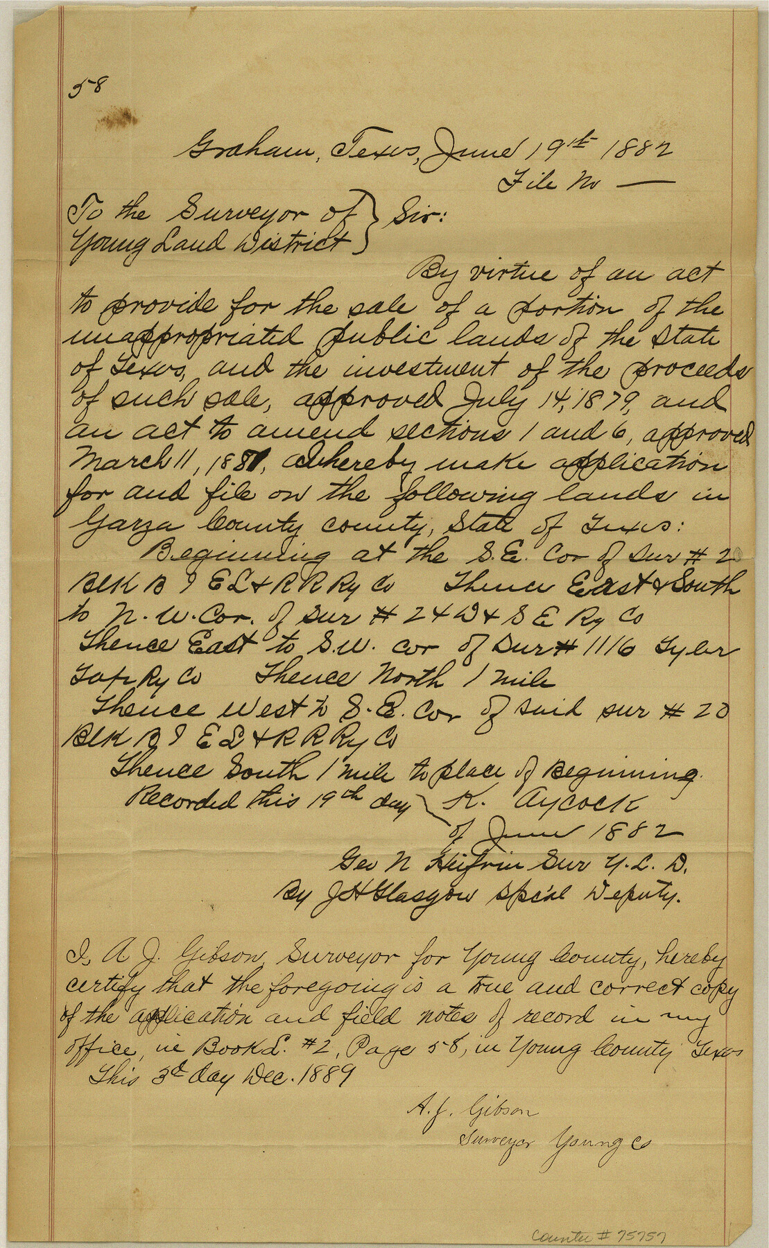
Old Miscellaneous File 35
Application and field notes for lands in Garza County
-
Map/Doc
75757
-
Collection
General Map Collection
-
Object Dates
1882/6/19 (Creation Date)
1985/2/8 (File Date)
-
People and Organizations
Geo. N. Heifrin (Surveyor/Engineer)
J.H. Glasgow (Surveyor/Engineer)
-
Height x Width
13.9 x 8.6 inches
35.3 x 21.8 cm
Part of: General Map Collection
Wilbarger County Boundary File 1

Print $52.00
- Digital $50.00
Wilbarger County Boundary File 1
Size 8.9 x 5.6 inches
Map/Doc 59916
Jim Hogg County Sketch File 6

Print $20.00
- Digital $50.00
Jim Hogg County Sketch File 6
1939
Size 17.9 x 19.6 inches
Map/Doc 11886
Current Miscellaneous File 53

Print $8.00
- Digital $50.00
Current Miscellaneous File 53
1945
Size 12.0 x 9.1 inches
Map/Doc 74038
Jeff Davis County Rolled Sketch 19A

Print $20.00
- Digital $50.00
Jeff Davis County Rolled Sketch 19A
Size 33.3 x 39.0 inches
Map/Doc 9266
Ellis County Boundary File 5

Print $4.00
- Digital $50.00
Ellis County Boundary File 5
Size 11.5 x 7.2 inches
Map/Doc 52990
Close-up: USA - Arkansas, Oklahoma, Louisiana, Texas

Close-up: USA - Arkansas, Oklahoma, Louisiana, Texas
1974
Size 35.1 x 23.1 inches
Map/Doc 96845
Pecos County Working Sketch 29
Print $20.00
- Digital $50.00
Pecos County Working Sketch 29
1935
Size 24.3 x 24.0 inches
Map/Doc 71501
Kent County Sketch File 3

Print $4.00
- Digital $50.00
Kent County Sketch File 3
Size 14.2 x 8.7 inches
Map/Doc 28825
Flight Mission No. CLL-1N, Frame 84, Willacy County

Print $20.00
- Digital $50.00
Flight Mission No. CLL-1N, Frame 84, Willacy County
1954
Size 18.5 x 22.2 inches
Map/Doc 87030
Cottle County Rolled Sketch 12

Print $20.00
- Digital $50.00
Cottle County Rolled Sketch 12
1959
Size 41.1 x 30.9 inches
Map/Doc 5570
Calhoun County Rolled Sketch 35

Print $20.00
- Digital $50.00
Calhoun County Rolled Sketch 35
1929
Size 36.5 x 26.6 inches
Map/Doc 5511
Comanche County

Print $20.00
- Digital $50.00
Comanche County
1896
Size 41.7 x 44.8 inches
Map/Doc 4736
You may also like
Proposed bombing and machine gun restricted areas along Gulf of Mexico from San Luis Pass to Aransas Pass

Print $20.00
- Digital $50.00
Proposed bombing and machine gun restricted areas along Gulf of Mexico from San Luis Pass to Aransas Pass
1941
Size 11.1 x 24.1 inches
Map/Doc 3024
Map of Blockline between 33 and 34, Township 5 North

Print $20.00
- Digital $50.00
Map of Blockline between 33 and 34, Township 5 North
1919
Size 20.5 x 34.5 inches
Map/Doc 92565
Parker County Sketch File 41

Print $4.00
- Digital $50.00
Parker County Sketch File 41
1877
Size 8.9 x 10.6 inches
Map/Doc 33587
Leon County Working Sketch 1

Print $20.00
- Digital $50.00
Leon County Working Sketch 1
Size 16.1 x 18.7 inches
Map/Doc 70400

Flight Mission No. CGI-3N, Frame 183, Cameron County

Print $20.00
- Digital $50.00
Flight Mission No. CGI-3N, Frame 183, Cameron County
1954
Size 18.6 x 22.2 inches
Map/Doc 84647
Wilson County Working Sketch 12

Print $20.00
- Digital $50.00
Wilson County Working Sketch 12
1981
Size 19.5 x 12.9 inches
Map/Doc 72592
Travis County

Print $40.00
- Digital $50.00
Travis County
1880
Size 62.1 x 50.2 inches
Map/Doc 87935
[Surveys in Power and Hewetson's Colony along the Aransas River, Middle Creek, Papalose Creek, and Blanco Creek]
![81, [Surveys in Power and Hewetson's Colony along the Aransas River, Middle Creek, Papalose Creek, and Blanco Creek], General Map Collection](https://historictexasmaps.com/wmedia_w700/maps/81.tif.jpg)
Print $20.00
- Digital $50.00
[Surveys in Power and Hewetson's Colony along the Aransas River, Middle Creek, Papalose Creek, and Blanco Creek]
1830
Size 21.6 x 21.2 inches
Map/Doc 81
Current Miscellaneous File 41

Print $8.00
- Digital $50.00
Current Miscellaneous File 41
Size 8.2 x 10.8 inches
Map/Doc 73977
Stephens County

Print $20.00
- Digital $50.00
Stephens County
1940
Size 42.9 x 41.0 inches
Map/Doc 63045
Intracoastal Waterway in Texas - Corpus Christi to Point Isabel including Arroyo Colorado to Mo. Pac. R.R. Bridge Near Harlingen

Print $20.00
- Digital $50.00
Intracoastal Waterway in Texas - Corpus Christi to Point Isabel including Arroyo Colorado to Mo. Pac. R.R. Bridge Near Harlingen
1934
Size 22.0 x 32.6 inches
Map/Doc 61886