Outer Continental Shelf Leasing Maps (Louisiana Offshore Operations)
D-7-3; D-7-4
-
Map/Doc
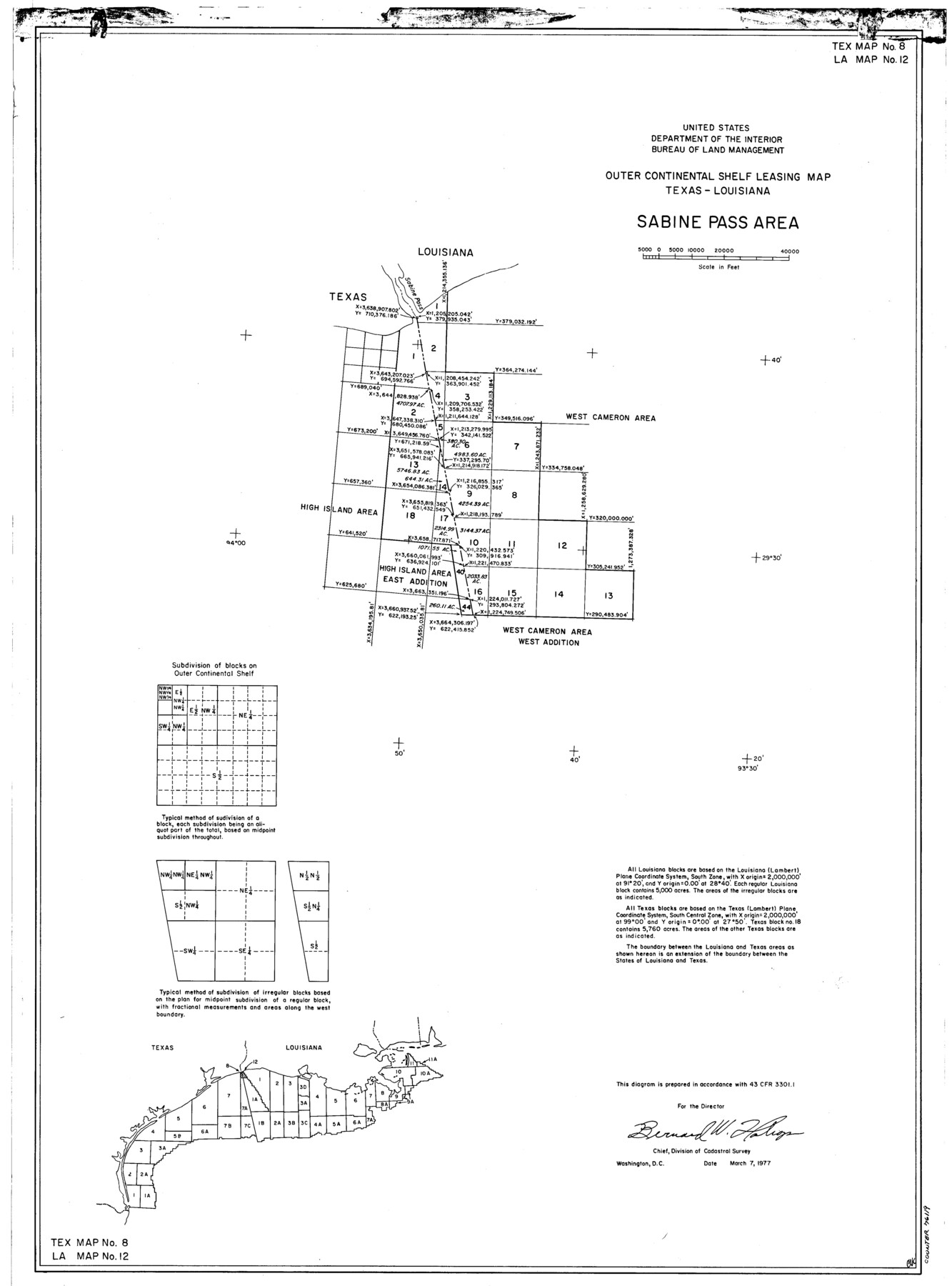
76119
-
Collection
General Map Collection
-
Object Dates
1977/3/7 (Creation Date)
-
Subjects
Energy Offshore Submerged Area
-
Height x Width
29.6 x 21.9 inches
75.2 x 55.6 cm
Part of: General Map Collection
Cooke County Sketch File 39

Print $20.00
- Digital $50.00
Cooke County Sketch File 39
1927
Size 10.9 x 18.2 inches
Map/Doc 11176
Flight Mission No. BRE-1P, Frame 147, Nueces County

Print $20.00
- Digital $50.00
Flight Mission No. BRE-1P, Frame 147, Nueces County
1956
Size 18.5 x 22.3 inches
Map/Doc 86707
Kenedy County Working Sketch 3

Print $20.00
- Digital $50.00
Kenedy County Working Sketch 3
1903
Size 30.3 x 38.4 inches
Map/Doc 70005

Martin County Rolled Sketch 2

Print $20.00
- Digital $50.00
Martin County Rolled Sketch 2
1906
Size 36.5 x 31.3 inches
Map/Doc 9492
Map of Colorado County

Print $20.00
- Digital $50.00
Map of Colorado County
1881
Size 22.5 x 21.4 inches
Map/Doc 3427
Nueces County Rolled Sketch 115

Print $215.00
Nueces County Rolled Sketch 115
1992
Size 24.2 x 35.2 inches
Map/Doc 7126
Panola County Sketch File 16

Print $4.00
- Digital $50.00
Panola County Sketch File 16
1882
Size 6.4 x 8.8 inches
Map/Doc 33476
[Gulf, Colorado & Santa Fe]
![64577, [Gulf, Colorado & Santa Fe], General Map Collection](https://historictexasmaps.com/wmedia_w700/maps/64577.tif.jpg)
Print $20.00
- Digital $50.00
[Gulf, Colorado & Santa Fe]
Size 32.4 x 47.4 inches
Map/Doc 64577
Glasscock County Rolled Sketch 3

Print $20.00
- Digital $50.00
Glasscock County Rolled Sketch 3
1906
Size 19.0 x 13.7 inches
Map/Doc 6014
Texas and part of Mexico & the United States, showing the route of the first Santa Fe Expedition

Print $20.00
- Digital $50.00
Texas and part of Mexico & the United States, showing the route of the first Santa Fe Expedition
1844
Size 18.1 x 13.2 inches
Map/Doc 94035
[Sketch for Mineral Application 16777]
![65653, [Sketch for Mineral Application 16777], General Map Collection](https://historictexasmaps.com/wmedia_w700/maps/65653-1.tif.jpg)
Print $40.00
- Digital $50.00
[Sketch for Mineral Application 16777]
Size 19.5 x 79.9 inches
Map/Doc 65653
You may also like
Rusk County Working Sketch 15

Print $20.00
- Digital $50.00
Rusk County Working Sketch 15
1972
Size 29.6 x 43.8 inches
Map/Doc 63650
Bosque County Working Sketch 12

Print $20.00
- Digital $50.00
Bosque County Working Sketch 12
1957
Size 18.3 x 21.8 inches
Map/Doc 67445
Hale County Boundary File 1

Print $44.00
- Digital $50.00
Hale County Boundary File 1
Size 10.0 x 30.9 inches
Map/Doc 54031
Newton County Working Sketch 43

Print $20.00
- Digital $50.00
Newton County Working Sketch 43
1982
Size 20.7 x 28.6 inches
Map/Doc 71289
Trinity River, Carl Switch Sheet/Chambers Creek

Print $4.00
- Digital $50.00
Trinity River, Carl Switch Sheet/Chambers Creek
1926
Size 27.9 x 27.0 inches
Map/Doc 65217
Willacy County

Print $20.00
- Digital $50.00
Willacy County
1921
Size 25.2 x 32.2 inches
Map/Doc 73325
Presidio County Rolled Sketch 78

Print $20.00
- Digital $50.00
Presidio County Rolled Sketch 78
1941
Size 32.4 x 39.2 inches
Map/Doc 7364
Map of Erath County

Print $20.00
- Digital $50.00
Map of Erath County
1872
Size 21.0 x 19.4 inches
Map/Doc 4537
Stephens County Sketch File 10

Print $4.00
- Digital $50.00
Stephens County Sketch File 10
Size 10.8 x 8.4 inches
Map/Doc 37042
Hardin County Sketch File 8

Print $8.00
- Digital $50.00
Hardin County Sketch File 8
1870
Size 12.6 x 8.1 inches
Map/Doc 25102
Terrell County Working Sketch 35a

Print $20.00
- Digital $50.00
Terrell County Working Sketch 35a
1948
Size 26.4 x 45.1 inches
Map/Doc 62128
Starr County Working Sketch 5

Print $20.00
- Digital $50.00
Starr County Working Sketch 5
1930
Size 35.8 x 24.8 inches
Map/Doc 63921