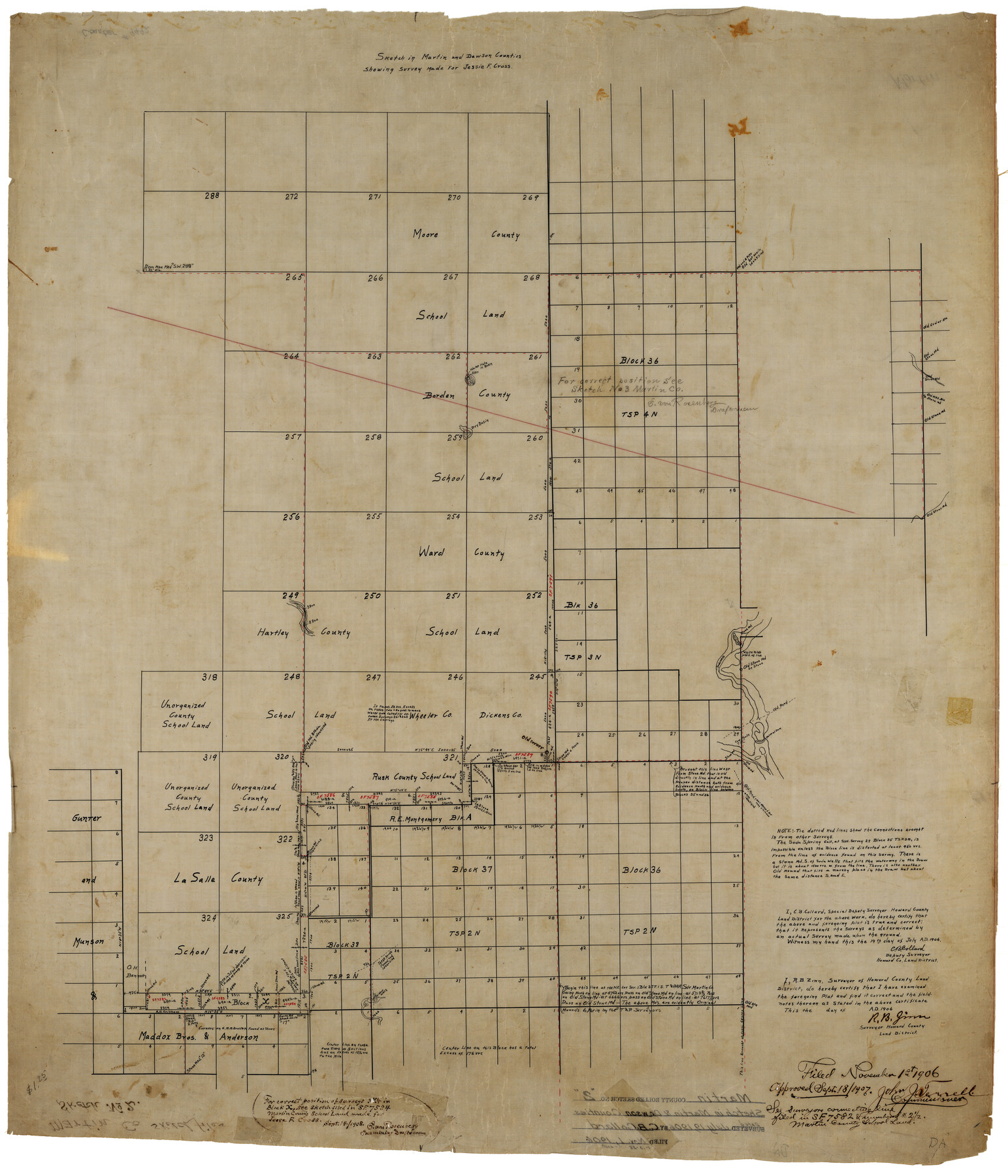
Martin County Rolled Sketch 2
Sketch in Martin and Dawson Counties showing surveys made for Jessie F. Cross
-
Map/Doc
9492
-
Collection
General Map Collection
-
Object Dates
1906/7/19 (Creation Date)
1906/11/1 (File Date)
-
People and Organizations
C.B. Collard (Surveyor/Engineer)
-
Counties
Martin Dawson
-
Subjects
Surveying Rolled Sketch
-
Height x Width
36.5 x 31.3 inches
92.7 x 79.5 cm
-
Medium
linen, manuscript
Part of: General Map Collection
A Map of the Internal Provinces of New Spain

Print $20.00
- Digital $50.00
A Map of the Internal Provinces of New Spain
1810
Size 19.8 x 21.0 inches
Map/Doc 95156
Red River County Rolled Sketch 3

Print $20.00
- Digital $50.00
Red River County Rolled Sketch 3
Size 36.9 x 31.0 inches
Map/Doc 9840
Harris County Boundary File 39 (18)

Print $4.00
- Digital $50.00
Harris County Boundary File 39 (18)
Size 12.7 x 7.9 inches
Map/Doc 54359
San Patricio County Rolled Sketch 46D

Print $20.00
- Digital $50.00
San Patricio County Rolled Sketch 46D
1983
Size 14.8 x 36.0 inches
Map/Doc 8375
Bexar County Sketch File 43

Print $4.00
- Digital $50.00
Bexar County Sketch File 43
1882
Size 8.7 x 10.2 inches
Map/Doc 14522
Sutton County Sketch File JAC

Print $20.00
- Digital $50.00
Sutton County Sketch File JAC
Size 24.5 x 23.4 inches
Map/Doc 12398

Brazos River, Widths of Floodways/Brazos and Navasota Rivers

Print $20.00
- Digital $50.00
Brazos River, Widths of Floodways/Brazos and Navasota Rivers
1921
Size 38.1 x 24.5 inches
Map/Doc 65292
Orange County Sabine River Leases 1,2,3,4

Print $20.00
- Digital $50.00
Orange County Sabine River Leases 1,2,3,4
1950
Size 36.5 x 22.4 inches
Map/Doc 1931
San Patricio County Working Sketch 2

Print $20.00
- Digital $50.00
San Patricio County Working Sketch 2
1911
Size 18.6 x 15.1 inches
Map/Doc 63764
Callahan County Boundary File 1

Print $120.00
- Digital $50.00
Callahan County Boundary File 1
Size 14.2 x 8.6 inches
Map/Doc 51025
Flight Mission No. DQN-2K, Frame 99, Calhoun County

Print $20.00
- Digital $50.00
Flight Mission No. DQN-2K, Frame 99, Calhoun County
1953
Size 18.7 x 22.3 inches
Map/Doc 84289
You may also like
Coleman County

Print $40.00
- Digital $50.00
Coleman County
1945
Size 54.9 x 37.1 inches
Map/Doc 1803
Terrell County Sketch File 18

Print $8.00
- Digital $50.00
Terrell County Sketch File 18
1908
Size 9.1 x 4.4 inches
Map/Doc 37941
Pecos County Working Sketch 27

Print $40.00
- Digital $50.00
Pecos County Working Sketch 27
1929
Size 36.9 x 50.8 inches
Map/Doc 71498
Fannin County Sketch File 6

Print $20.00
- Digital $50.00
Fannin County Sketch File 6
1857
Size 17.0 x 14.5 inches
Map/Doc 11469
Karnes County

Print $20.00
- Digital $50.00
Karnes County
1921
Size 44.3 x 39.6 inches
Map/Doc 95551
[Sketch Showing Blocks O18, P Mc, B10 and B11]
![93105, [Sketch Showing Blocks O18, P Mc, B10 and B11], Twichell Survey Records](https://historictexasmaps.com/wmedia_w700/maps/93105-1.tif.jpg)
Print $3.00
- Digital $50.00
[Sketch Showing Blocks O18, P Mc, B10 and B11]
Size 11.1 x 11.1 inches
Map/Doc 93105
Highway Addition to Littlefield, Texas

Print $3.00
- Digital $50.00
Highway Addition to Littlefield, Texas
Size 14.3 x 11.7 inches
Map/Doc 92266
Matagorda County Sketch File 42

Print $38.00
- Digital $50.00
Matagorda County Sketch File 42
1912
Size 14.2 x 8.8 inches
Map/Doc 30834
Stephens County

Print $20.00
- Digital $50.00
Stephens County
1879
Size 27.8 x 19.6 inches
Map/Doc 4051
El Paso County Rolled Sketch 51

Print $40.00
- Digital $50.00
El Paso County Rolled Sketch 51
Size 42.9 x 75.3 inches
Map/Doc 8877
Hutchinson County Working Sketch 11

Print $20.00
- Digital $50.00
Hutchinson County Working Sketch 11
1924
Size 20.4 x 29.4 inches
Map/Doc 66369
Armstrong County Sketch File A-2

Print $40.00
- Digital $50.00
Armstrong County Sketch File A-2
1918
Size 27.0 x 36.6 inches
Map/Doc 10843