Armstrong County Sketch File A-2
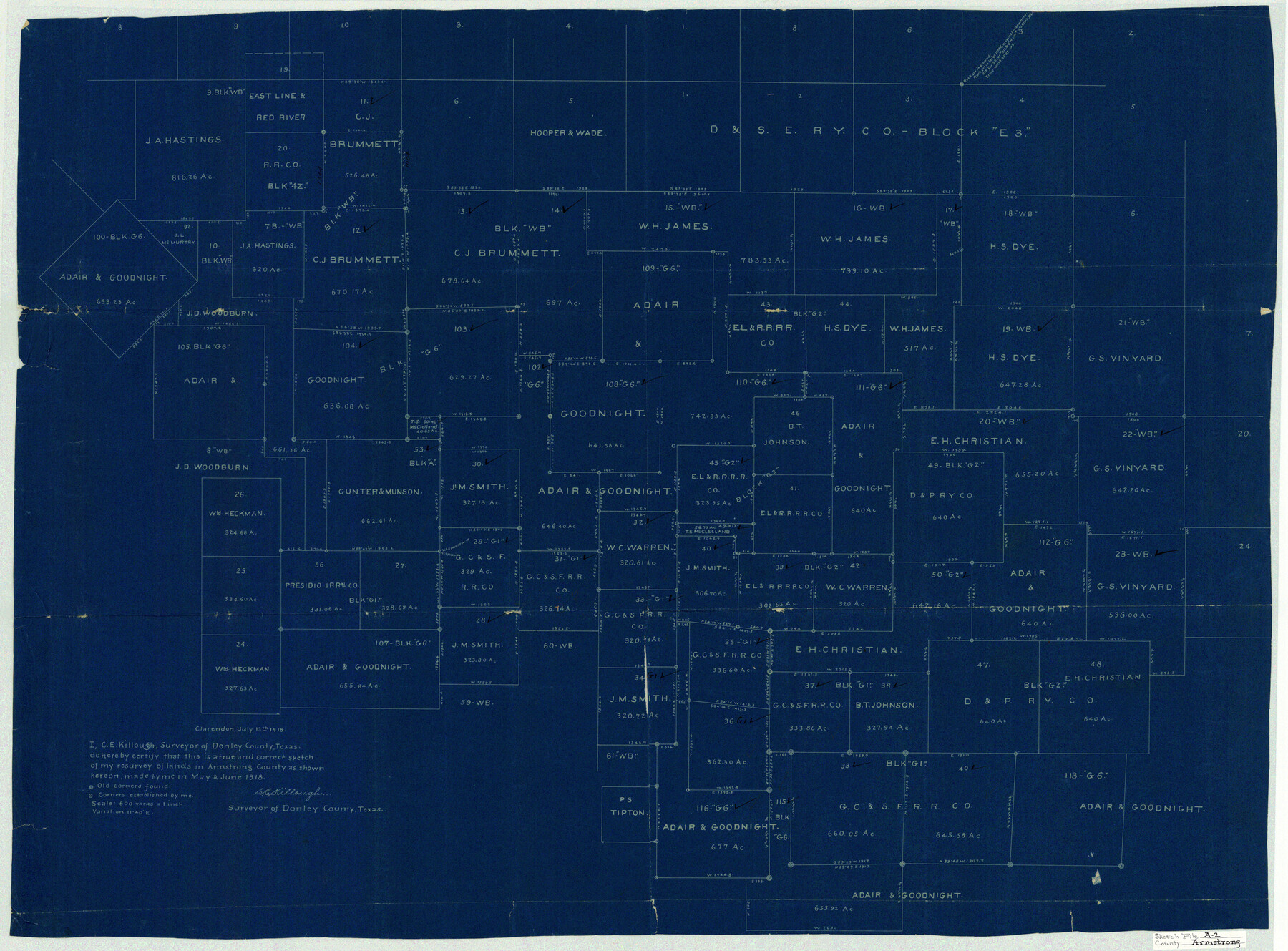
[Sketch showing Blocks G1, G2, G6, A, WB, and 4Z]
-
Map/Doc
10843
-
Collection
General Map Collection
-
Object Dates
1918 (Survey Date)
1918 (Survey Date)
1918/6/13 (Creation Date)
-
People and Organizations
C.E. Killough (Surveyor/Engineer)
-
Counties
Armstrong
-
Subjects
Surveying Sketch File
-
Height x Width
27.0 x 36.6 inches
68.6 x 93.0 cm
-
Medium
blueprint/diazo
-
Scale
1" = 600 varas
Part of: General Map Collection
Atascosa County Rolled Sketch 11

Print $20.00
- Digital $50.00
Atascosa County Rolled Sketch 11
1943
Size 22.8 x 38.0 inches
Map/Doc 5094
Flight Mission No. DCL-7C, Frame 150, Kenedy County

Print $20.00
- Digital $50.00
Flight Mission No. DCL-7C, Frame 150, Kenedy County
1943
Size 18.5 x 22.2 inches
Map/Doc 86107
Flight Mission No. DAG-18K, Frame 75, Matagorda County

Print $20.00
- Digital $50.00
Flight Mission No. DAG-18K, Frame 75, Matagorda County
1952
Size 18.5 x 19.1 inches
Map/Doc 86368
Presidio County Sketch File E

Print $20.00
- Digital $50.00
Presidio County Sketch File E
Size 15.9 x 20.0 inches
Map/Doc 11702
Flight Mission No. CUG-3P, Frame 35, Kleberg County

Print $20.00
- Digital $50.00
Flight Mission No. CUG-3P, Frame 35, Kleberg County
1956
Size 18.6 x 22.3 inches
Map/Doc 86240
Maps of Gulf Intracoastal Waterway, Texas - Sabine River to the Rio Grande and connecting waterways including ship channels

Print $20.00
- Digital $50.00
Maps of Gulf Intracoastal Waterway, Texas - Sabine River to the Rio Grande and connecting waterways including ship channels
1966
Size 14.5 x 22.3 inches
Map/Doc 61949
Midland County Rolled Sketch 4A

Print $40.00
- Digital $50.00
Midland County Rolled Sketch 4A
1951
Size 43.0 x 85.3 inches
Map/Doc 61735
Kinney County Working Sketch 21

Print $20.00
- Digital $50.00
Kinney County Working Sketch 21
1950
Size 23.7 x 18.5 inches
Map/Doc 70203

Wilson County Boundary File 2

Print $10.00
- Digital $50.00
Wilson County Boundary File 2
Size 12.3 x 8.3 inches
Map/Doc 60078
Leon County Working Sketch 47

Print $20.00
- Digital $50.00
Leon County Working Sketch 47
1980
Size 29.3 x 25.8 inches
Map/Doc 70446
Flight Mission No. BQR-9K, Frame 48, Brazoria County

Print $20.00
- Digital $50.00
Flight Mission No. BQR-9K, Frame 48, Brazoria County
1952
Size 18.7 x 22.2 inches
Map/Doc 84052
You may also like
Right of Way & Track Map, The Texas & Pacific Ry. Co. Main Line

Print $20.00
- Digital $50.00
Right of Way & Track Map, The Texas & Pacific Ry. Co. Main Line
Size 11.0 x 18.3 inches
Map/Doc 64687
Map of north end of Brazos Island

Print $20.00
- Digital $50.00
Map of north end of Brazos Island
Size 27.5 x 18.3 inches
Map/Doc 72906
Topographical Map of the Rio Grande, Sheet No. 11

Print $20.00
- Digital $50.00
Topographical Map of the Rio Grande, Sheet No. 11
1912
Map/Doc 89535

English Field Notes of the Spanish Archives - Book 1

English Field Notes of the Spanish Archives - Book 1
1833
Map/Doc 96527
Sutton County Sketch File 1

Print $6.00
- Digital $50.00
Sutton County Sketch File 1
1885
Size 14.3 x 8.9 inches
Map/Doc 37348
Fayette County Working Sketch 2

Print $20.00
- Digital $50.00
Fayette County Working Sketch 2
1979
Size 40.6 x 37.8 inches
Map/Doc 69166
Galveston County Sketch File 34a

Print $20.00
- Digital $50.00
Galveston County Sketch File 34a
Size 11.4 x 20.3 inches
Map/Doc 11537
Henderson County Working Sketch 35

Print $20.00
- Digital $50.00
Henderson County Working Sketch 35
1963
Size 19.3 x 38.1 inches
Map/Doc 66168
Crane County Sketch File A10

Print $20.00
- Digital $50.00
Crane County Sketch File A10
Size 18.0 x 24.7 inches
Map/Doc 11214
Dépt. des Ardennes

Print $20.00
- Digital $50.00
Dépt. des Ardennes
Size 14.5 x 20.5 inches
Map/Doc 94448
Flight Mission No. DIX-10P, Frame 67, Aransas County

Print $20.00
- Digital $50.00
Flight Mission No. DIX-10P, Frame 67, Aransas County
1956
Size 18.7 x 22.3 inches
Map/Doc 83928