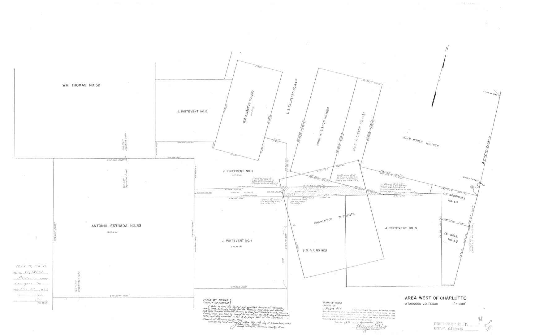
Atascosa County Rolled Sketch 11
Area west of Charlotte
-
Map/Doc
5094
-
Collection
General Map Collection
-
Object Dates
12/13/1943 (Creation Date)
12/17/1943 (File Date)
-
People and Organizations
Hayes Dix (Surveyor/Engineer)
John M. Peel (County/Other Clerk)
-
Counties
Atascosa
-
Subjects
Surveying Rolled Sketch
-
Height x Width
22.8 x 38.0 inches
57.9 x 96.5 cm
-
Medium
blueprint/diazo
-
Scale
1" = 300 varas
Part of: General Map Collection
Potter County Sketch File 4

Print $10.00
- Digital $50.00
Potter County Sketch File 4
1882
Size 14.1 x 8.6 inches
Map/Doc 34382
Calhoun County Rolled Sketch 30

Print $20.00
- Digital $50.00
Calhoun County Rolled Sketch 30
1974
Size 18.5 x 27.5 inches
Map/Doc 5496
Shelby County Rolled Sketch 4

Print $20.00
- Digital $50.00
Shelby County Rolled Sketch 4
1942
Size 36.4 x 43.2 inches
Map/Doc 9920
Guadalupe County Sketch File 3

Print $4.00
- Digital $50.00
Guadalupe County Sketch File 3
Size 8.0 x 12.6 inches
Map/Doc 24650
Flight Mission No. DQO-7K, Frame 83, Galveston County

Print $20.00
- Digital $50.00
Flight Mission No. DQO-7K, Frame 83, Galveston County
1952
Size 18.8 x 22.5 inches
Map/Doc 85110
Brewster County Working Sketch 72

Print $20.00
- Digital $50.00
Brewster County Working Sketch 72
1965
Size 20.7 x 24.6 inches
Map/Doc 67672
Presidio County Rolled Sketch T-3

Print $20.00
- Digital $50.00
Presidio County Rolled Sketch T-3
Size 36.6 x 28.9 inches
Map/Doc 7417
Harris County Sketch File 65

Print $20.00
- Digital $50.00
Harris County Sketch File 65
Size 23.5 x 35.1 inches
Map/Doc 11660
Polk County Sketch File 45

Print $4.00
- Digital $50.00
Polk County Sketch File 45
Size 11.3 x 8.8 inches
Map/Doc 34376
Harris County Sketch File 21

Print $4.00
- Digital $50.00
Harris County Sketch File 21
1862
Size 13.1 x 8.2 inches
Map/Doc 25373
El Paso County Working Sketch 44

Print $20.00
- Digital $50.00
El Paso County Working Sketch 44
1992
Size 25.6 x 25.4 inches
Map/Doc 69066
Andrews County Rolled Sketch 40

Print $20.00
- Digital $50.00
Andrews County Rolled Sketch 40
Size 37.2 x 23.0 inches
Map/Doc 77180
You may also like
[Three Mile Line and Three League Line]
![76120, [Three Mile Line and Three League Line], General Map Collection](https://historictexasmaps.com/wmedia_w700/maps/76120.tif.jpg)
Print $20.00
- Digital $50.00
[Three Mile Line and Three League Line]
1973
Size 43.2 x 33.3 inches
Map/Doc 76120
Hidalgo County Sketch File 8

Print $4.00
- Digital $50.00
Hidalgo County Sketch File 8
1890
Size 14.1 x 8.6 inches
Map/Doc 26407
King County Sketch File 3

Print $20.00
- Digital $50.00
King County Sketch File 3
Size 22.2 x 27.1 inches
Map/Doc 11934
Louisiana and Texas Intracoastal Waterway - Dredging from Freeport Harbor to Caney Creek - Sheet 2

Print $20.00
- Digital $50.00
Louisiana and Texas Intracoastal Waterway - Dredging from Freeport Harbor to Caney Creek - Sheet 2
1940
Size 31.2 x 41.3 inches
Map/Doc 61817

San Patricio County Rolled Sketch 53

Print $20.00
- Digital $50.00
San Patricio County Rolled Sketch 53
1996
Size 19.1 x 25.3 inches
Map/Doc 7738
Wood County Boundary File 6

Print $32.00
- Digital $50.00
Wood County Boundary File 6
Size 14.3 x 8.6 inches
Map/Doc 60180
Texas and part of Mexico and the United States showing the Route of the First Santa Fe Expedition

Print $20.00
Texas and part of Mexico and the United States showing the Route of the First Santa Fe Expedition
1844
Size 20.3 x 15.8 inches
Map/Doc 79730
Chambers County Sketch File 48

Print $88.00
- Digital $50.00
Chambers County Sketch File 48
1925
Size 14.3 x 8.8 inches
Map/Doc 18002
Travis County Sketch File 73

Print $4.00
- Digital $50.00
Travis County Sketch File 73
1847
Size 13.0 x 8.3 inches
Map/Doc 38462
El Paso County Working Sketch 1

Print $40.00
- Digital $50.00
El Paso County Working Sketch 1
1911
Size 25.4 x 90.6 inches
Map/Doc 69022
[Resurvey of Block 1 - W. H. Godair]
![92898, [Resurvey of Block 1 - W. H. Godair], Twichell Survey Records](https://historictexasmaps.com/wmedia_w700/maps/92898-1.tif.jpg)
Print $20.00
- Digital $50.00
[Resurvey of Block 1 - W. H. Godair]
1923
Size 22.4 x 9.5 inches
Map/Doc 92898