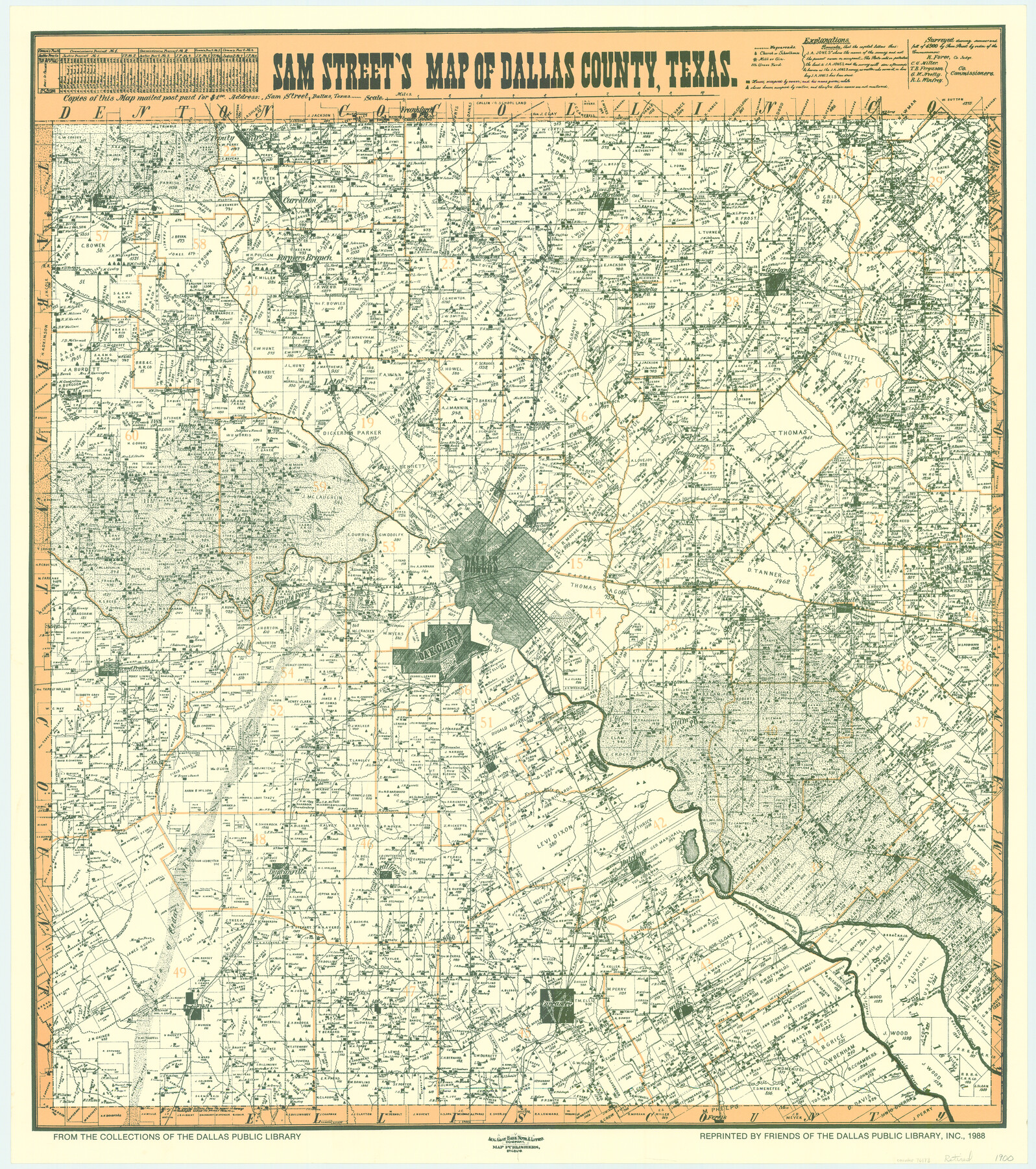
Sam Street's Map of Dallas County, Texas
-
Map/Doc
76173
-
Collection
General Map Collection
-
Object Dates
1900 (Creation Date)
-
People and Organizations
Sam Street, Dallas, Texas (Publisher)
August Gast Bank Note & Lithograph Company (Lithographer)
-
Counties
Dallas
-
Subjects
County
-
Height x Width
32.1 x 28.5 inches
81.5 x 72.4 cm
-
Comments
From the collections of the Dallas Public Library; reprinted 1988. Available for research only---for copies of this map please contact the Dallas Public Library.
-
Features
Cottonwood Creek
Vernoy Branch of Mountain Creek
Walnut Creek
Five Mile Post Office
Lisbon
Five Mile Creek
Rylie Post Office
TTRR
Elam
Oak Cliff
Mountain Creek
Duncanville
Mill House Lake
Grand Prairie
Bear Creek
Eagle Ford
Dallas
Oak Land Cemetery
White Rock Creek
Orphan Home
T&P
Wilmer
Frankford
Parson's Slough
Ferris
Desoto Post Office
Holland Branch of Trinity River
Face of Cedar Ridge
Cedar Hill
Ten Mile Creek
Fish Pond
Lancaster
Mesquite Creek
Goff Branch of Trinity River
Seagoville
Simonds
Kleberg
Dowdy's Club Lake
Fin and Feather Lake
Hutchins
MK&T
Wheatland
Rowlett Creek
Coppell
Trinity River
Elm Fork of Trinity River
West Fork of Trinity River
East Fork of Trinity River
Farmers Branch
Alpha Post Office
Audelia Post Office
Duck Creek
Hay Creek
Hackberry Creek
Rowlette [sic]
Garland
Muddy Creek
Pleasant Valley
GC&SF
Spring Creek
Richardson
Carralton [sic]
Trinity Mill
D&W
South Mesquite Creek
North Mesquite Creek
Mesquite
New Hope
Thomas' Ranch
Tuner's Place or Ranch
Sowers
Estella Post Office
Finley Post Office
Owen's Lake
SLS
Letot
Rollins Post Office
Calhoun
Reinhard
Housley Post Office
House Lake
Bois D'Arc Creek
Centreville
White Creek
Part of: General Map Collection
Leon County Working Sketch 41

Print $40.00
- Digital $50.00
Leon County Working Sketch 41
1980
Size 61.2 x 43.2 inches
Map/Doc 70440
Map of Val Verde County

Print $20.00
- Digital $50.00
Map of Val Verde County
1898
Size 42.9 x 37.5 inches
Map/Doc 63098
Gaines County Rolled Sketch G3A

Print $20.00
- Digital $50.00
Gaines County Rolled Sketch G3A
1902
Size 22.5 x 31.1 inches
Map/Doc 5947
Hardeman County Boundary File 3a

Print $42.00
- Digital $50.00
Hardeman County Boundary File 3a
Size 56.8 x 12.3 inches
Map/Doc 54384
Harris County Rolled Sketch 62

Print $20.00
- Digital $50.00
Harris County Rolled Sketch 62
1930
Size 29.9 x 28.7 inches
Map/Doc 6108
Runnels County Rolled Sketch 43

Print $20.00
- Digital $50.00
Runnels County Rolled Sketch 43
Size 28.3 x 45.8 inches
Map/Doc 7531
Austin County Boundary File 1

Print $44.00
- Digital $50.00
Austin County Boundary File 1
Size 7.0 x 8.2 inches
Map/Doc 50223
[Surveys in Austin's Colony along the Navasota River and Ten Mile Creek]
![80, [Surveys in Austin's Colony along the Navasota River and Ten Mile Creek], General Map Collection](https://historictexasmaps.com/wmedia_w700/maps/80.tif.jpg)
Print $20.00
- Digital $50.00
[Surveys in Austin's Colony along the Navasota River and Ten Mile Creek]
1821
Size 29.2 x 18.0 inches
Map/Doc 80
Brazoria County Rolled Sketch 31

Print $20.00
- Digital $50.00
Brazoria County Rolled Sketch 31
Size 25.6 x 45.9 inches
Map/Doc 5169
Bailey County Working Sketch 4

Print $20.00
- Digital $50.00
Bailey County Working Sketch 4
1937
Size 27.0 x 32.0 inches
Map/Doc 67591
Flight Mission No. CRK-5P, Frame 162, Refugio County

Print $20.00
- Digital $50.00
Flight Mission No. CRK-5P, Frame 162, Refugio County
1956
Size 18.5 x 22.3 inches
Map/Doc 86943
McMullen County Working Sketch 58

Print $40.00
- Digital $50.00
McMullen County Working Sketch 58
1984
Size 61.2 x 40.0 inches
Map/Doc 70759
You may also like
Map of the Western Part of Bexar District

Print $40.00
- Digital $50.00
Map of the Western Part of Bexar District
1849
Size 64.0 x 54.3 inches
Map/Doc 16944

Old Miscellaneous File 21

Print $16.00
- Digital $50.00
Old Miscellaneous File 21
Size 14.3 x 8.7 inches
Map/Doc 75583
Franklin County Boundary File 1

Print $8.00
- Digital $50.00
Franklin County Boundary File 1
Size 12.9 x 8.1 inches
Map/Doc 53569
Matagorda County Sketch File 24

Print $10.00
- Digital $50.00
Matagorda County Sketch File 24
1900
Size 8.2 x 5.1 inches
Map/Doc 30787
Ector County Sketch File 3

Print $20.00
- Digital $50.00
Ector County Sketch File 3
1889
Size 16.2 x 35.5 inches
Map/Doc 11417
Presidio County Rolled Sketch 96

Print $20.00
- Digital $50.00
Presidio County Rolled Sketch 96
Size 12.3 x 45.9 inches
Map/Doc 9782
[H. & G. N. Block B4]
![90275, [H. & G. N. Block B4], Twichell Survey Records](https://historictexasmaps.com/wmedia_w700/maps/90275-1.tif.jpg)
Print $20.00
- Digital $50.00
[H. & G. N. Block B4]
Size 21.4 x 18.2 inches
Map/Doc 90275
Cameron County Rolled Sketch 25

Print $20.00
- Digital $50.00
Cameron County Rolled Sketch 25
1977
Size 24.5 x 30.4 inches
Map/Doc 5793
Ellis Addition to the City of Lubbock, Being a Subdivision of a Part of the SW/4 of SW/4 Sec. 4, Blk. A

Print $3.00
- Digital $50.00
Ellis Addition to the City of Lubbock, Being a Subdivision of a Part of the SW/4 of SW/4 Sec. 4, Blk. A
1952
Size 9.5 x 12.0 inches
Map/Doc 92710
Collin County Texas

Print $20.00
- Digital $50.00
Collin County Texas
1895
Size 20.7 x 17.5 inches
Map/Doc 794
Travis County Rolled Sketch 47

Print $40.00
- Digital $50.00
Travis County Rolled Sketch 47
1925
Size 24.9 x 56.8 inches
Map/Doc 10016