Loving County Sketch File 8
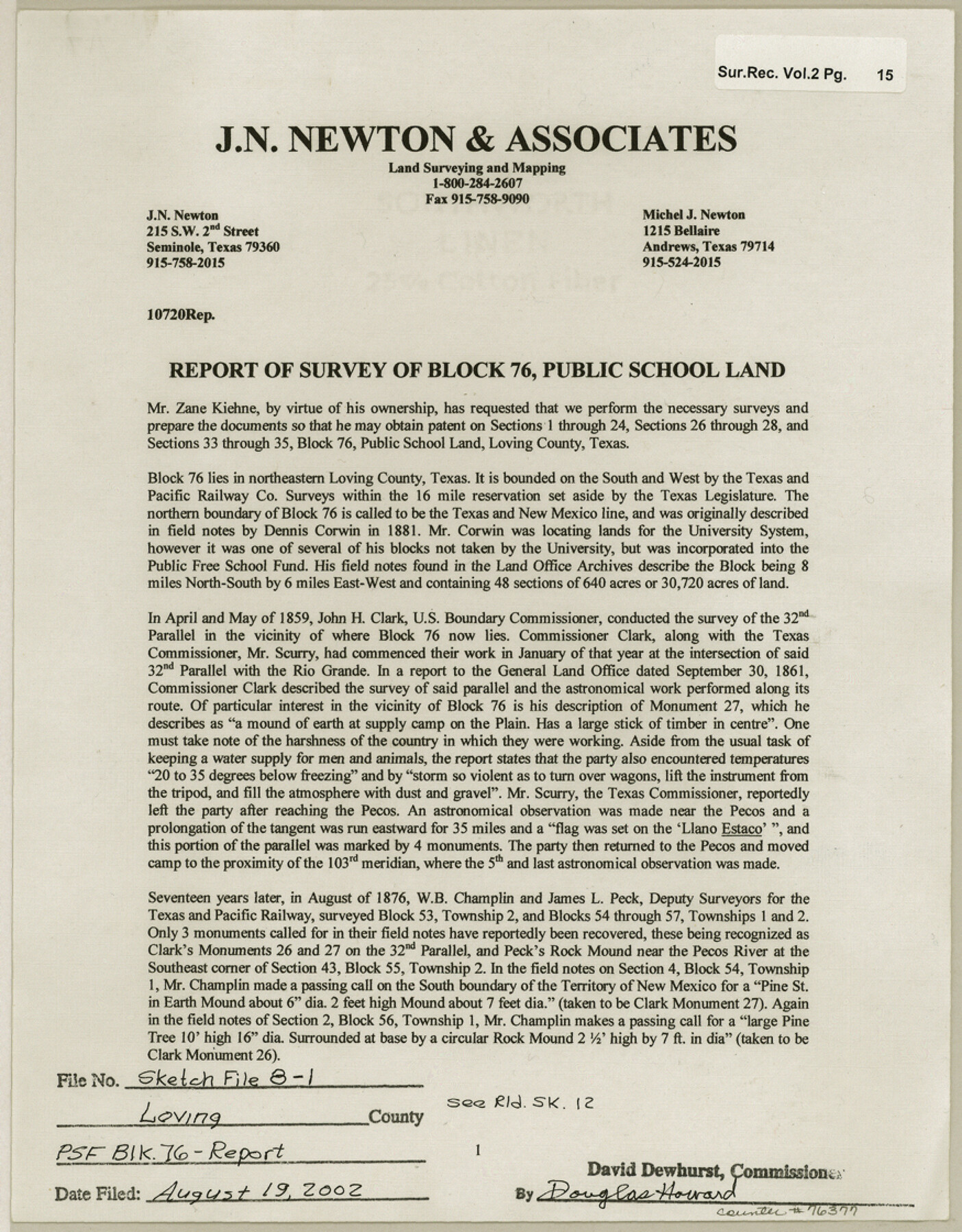
Report of survey of Block 76, Public School Land
-
Map/Doc
76377
-
Collection
General Map Collection
-
Object Dates
5/29/2002 (Creation Date)
8/19/2002 (File Date)
-
People and Organizations
J.N. Newton (Surveyor/Engineer)
Dennis Corwin (Surveyor/Engineer)
W.B. Champlin (Surveyor/Engineer)
James L. Peck (Surveyor/Engineer)
W.D. Twichell (Surveyor/Engineer)
E.L. Stratton (Surveyor/Engineer)
John H. Clark (Surveyor/Engineer)
Michel J. Newton (Chainman/Field Personnel)
Kristi E. Ertel (Chainman/Field Personnel)
-
Counties
Loving
-
Subjects
Surveying Sketch File
-
Height x Width
11.2 x 8.7 inches
28.4 x 22.1 cm
-
Medium
paper, print
-
Comments
See Loving County Rolled Sketch 12 (76418) for sketch.
-
Features
Rio Grande
Pecos River
Llano Estacado
Related maps
Loving County Rolled Sketch 12

Print $20.00
- Digital $50.00
Loving County Rolled Sketch 12
Size 35.5 x 42.6 inches
Map/Doc 76418
Part of: General Map Collection
Young County Working Sketch 15

Print $20.00
- Digital $50.00
Young County Working Sketch 15
1952
Size 13.7 x 18.0 inches
Map/Doc 62038
1882 Map of the Texas & Pacific R-Y Reserve

Print $20.00
- Digital $50.00
1882 Map of the Texas & Pacific R-Y Reserve
1887
Size 44.5 x 31.7 inches
Map/Doc 83559
Flight Mission No. CGI-1N, Frame 182, Cameron County

Print $20.00
- Digital $50.00
Flight Mission No. CGI-1N, Frame 182, Cameron County
1955
Size 18.6 x 22.3 inches
Map/Doc 84517
Hunt County Boundary File 11a

Print $15.00
- Digital $50.00
Hunt County Boundary File 11a
Size 11.1 x 8.9 inches
Map/Doc 55272
Terrell County Working Sketch 19

Print $20.00
- Digital $50.00
Terrell County Working Sketch 19
1932
Size 18.6 x 25.6 inches
Map/Doc 69801
Upton County Working Sketch 12

Print $40.00
- Digital $50.00
Upton County Working Sketch 12
1937
Size 43.6 x 77.9 inches
Map/Doc 69508
Flight Mission No. DCL-5C, Frame 3, Kenedy County

Print $20.00
- Digital $50.00
Flight Mission No. DCL-5C, Frame 3, Kenedy County
1943
Size 18.4 x 22.2 inches
Map/Doc 85828
Gray County Sketch File 6

Print $20.00
- Digital $50.00
Gray County Sketch File 6
1882
Size 26.3 x 21.4 inches
Map/Doc 11575
Reagan County Working Sketch 14b

Print $20.00
- Digital $50.00
Reagan County Working Sketch 14b
Size 20.3 x 9.0 inches
Map/Doc 71855
Madison County Working Sketch 6

Print $2.00
- Digital $50.00
Madison County Working Sketch 6
1982
Size 10.5 x 7.7 inches
Map/Doc 70768
Stonewall County Sketch File 26

Print $20.00
- Digital $50.00
Stonewall County Sketch File 26
1953
Size 35.7 x 36.8 inches
Map/Doc 10376
Flight Mission No. BRE-1P, Frame 26, Nueces County

Print $20.00
- Digital $50.00
Flight Mission No. BRE-1P, Frame 26, Nueces County
1956
Size 18.6 x 22.5 inches
Map/Doc 86621
You may also like
Motley County Sketch File 9a (N)

Print $4.00
- Digital $50.00
Motley County Sketch File 9a (N)
1885
Size 14.2 x 8.6 inches
Map/Doc 32024
Pecos County Rolled Sketch 32

Print $20.00
- Digital $50.00
Pecos County Rolled Sketch 32
1890
Size 21.0 x 14.1 inches
Map/Doc 7214
Upton County Rolled Sketch 51

Print $20.00
- Digital $50.00
Upton County Rolled Sketch 51
1961
Size 34.0 x 29.8 inches
Map/Doc 8086
Flight Mission No. BQY-4M, Frame 65, Harris County

Print $20.00
- Digital $50.00
Flight Mission No. BQY-4M, Frame 65, Harris County
1953
Size 18.7 x 22.4 inches
Map/Doc 85274
[Town plat of San Marcos]
![83002, [Town plat of San Marcos], Non-GLO Digital Images](https://historictexasmaps.com/wmedia_w700/maps/83002.tif.jpg)
Print $20.00
[Town plat of San Marcos]
Size 15.8 x 10.1 inches
Map/Doc 83002
Starr County Sketch File 8

Print $7.00
- Digital $50.00
Starr County Sketch File 8
Size 10.1 x 12.4 inches
Map/Doc 36858
Flight Mission No. DCL-7C, Frame 52, Kenedy County

Print $20.00
- Digital $50.00
Flight Mission No. DCL-7C, Frame 52, Kenedy County
1943
Size 16.7 x 16.4 inches
Map/Doc 86040
Travis County Working Sketch 9

Print $20.00
- Digital $50.00
Travis County Working Sketch 9
1918
Size 21.9 x 28.9 inches
Map/Doc 69393
Texas Hill Country Trail Region

Texas Hill Country Trail Region
Size 18.1 x 24.2 inches
Map/Doc 96872
Galveston County Working Sketch 20

Print $20.00
- Digital $50.00
Galveston County Working Sketch 20
1983
Size 28.1 x 38.0 inches
Map/Doc 69357
[Canadian River and surveys north]
![91780, [Canadian River and surveys north], Twichell Survey Records](https://historictexasmaps.com/wmedia_w700/maps/91780-1.tif.jpg)
Print $20.00
- Digital $50.00
[Canadian River and surveys north]
Size 38.3 x 21.6 inches
Map/Doc 91780
Leon County Working Sketch 26

Print $20.00
- Digital $50.00
Leon County Working Sketch 26
1969
Size 43.1 x 46.9 inches
Map/Doc 70425