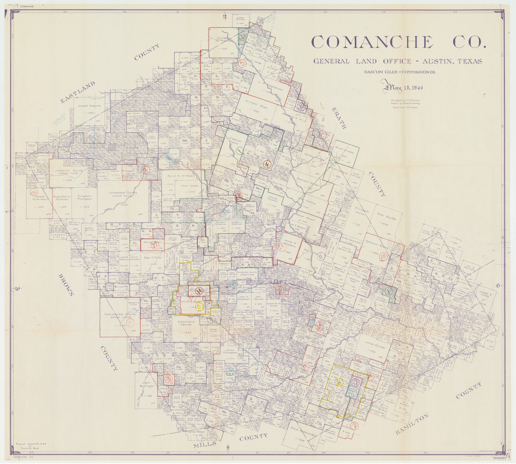
Comanche County Working Sketch Graphic Index
-
Map/Doc
76502
-
Collection
General Map Collection
-
Object Dates
5/15/1944 (Creation Date)
-
People and Organizations
G.C. Morriss (Compiler)
Eltea Armstrong (Draftsman)
-
Counties
Comanche
-
Subjects
County Surveying Working Sketch
-
Height x Width
41.5 x 46.2 inches
105.4 x 117.4 cm
-
Scale
1" = 2000 varas
Part of: General Map Collection
Howard County Rolled Sketch 10

Print $20.00
- Digital $50.00
Howard County Rolled Sketch 10
Size 19.5 x 21.3 inches
Map/Doc 6240
Hopkins County Sketch File 17

Print $6.00
- Digital $50.00
Hopkins County Sketch File 17
1870
Size 7.8 x 8.0 inches
Map/Doc 26720
Flight Mission No. BQR-7K, Frame 23, Brazoria County

Print $20.00
- Digital $50.00
Flight Mission No. BQR-7K, Frame 23, Brazoria County
1952
Size 18.4 x 22.2 inches
Map/Doc 84021
Flight Mission No. DQO-8K, Frame 15, Galveston County

Print $20.00
- Digital $50.00
Flight Mission No. DQO-8K, Frame 15, Galveston County
1952
Size 18.7 x 22.4 inches
Map/Doc 85138
Angelina County Sketch File 20

Print $40.00
- Digital $50.00
Angelina County Sketch File 20
1882
Size 19.7 x 29.4 inches
Map/Doc 10816
Real County Working Sketch 5

Print $20.00
- Digital $50.00
Real County Working Sketch 5
1924
Size 17.9 x 29.1 inches
Map/Doc 71897
Galveston County NRC Article 33.136 Sketch 62

Print $28.00
- Digital $50.00
Galveston County NRC Article 33.136 Sketch 62
2009
Size 24.0 x 36.0 inches
Map/Doc 94596
Palo Pinto County Rolled Sketch 4

Print $20.00
- Digital $50.00
Palo Pinto County Rolled Sketch 4
Size 15.9 x 23.2 inches
Map/Doc 7189
Flight Mission No. DIX-3P, Frame 167, Aransas County

Print $20.00
- Digital $50.00
Flight Mission No. DIX-3P, Frame 167, Aransas County
1956
Size 17.8 x 18.0 inches
Map/Doc 83773
Hill County Sketch File 24

Print $40.00
- Digital $50.00
Hill County Sketch File 24
Size 15.6 x 13.8 inches
Map/Doc 26516
Brewster County Working Sketch 66

Print $20.00
- Digital $50.00
Brewster County Working Sketch 66
1958
Size 42.2 x 30.6 inches
Map/Doc 67667
Webb County Rolled Sketch 15

Print $20.00
- Digital $50.00
Webb County Rolled Sketch 15
Size 25.1 x 15.1 inches
Map/Doc 8179
You may also like
Zavala County Sketch File 4

Print $20.00
- Digital $50.00
Zavala County Sketch File 4
1852
Size 17.7 x 14.7 inches
Map/Doc 12726
Flight Mission No. BRA-7M, Frame 132, Jefferson County

Print $20.00
- Digital $50.00
Flight Mission No. BRA-7M, Frame 132, Jefferson County
1953
Size 18.5 x 19.6 inches
Map/Doc 85526
Rio Grande, McAllen Sheet

Print $20.00
- Digital $50.00
Rio Grande, McAllen Sheet
1937
Size 37.4 x 37.5 inches
Map/Doc 65118
Motley County Sketch File 10 (N)

Print $20.00
- Digital $50.00
Motley County Sketch File 10 (N)
1900
Size 14.0 x 8.5 inches
Map/Doc 32026
Presidio County Sketch File 75

Print $30.00
- Digital $50.00
Presidio County Sketch File 75
1946
Size 8.9 x 14.3 inches
Map/Doc 34691
Crockett County Working Sketch 48

Print $20.00
- Digital $50.00
Crockett County Working Sketch 48
1938
Size 23.8 x 13.2 inches
Map/Doc 68381
General Highway Map, Sherman County, Texas

Print $20.00
General Highway Map, Sherman County, Texas
1961
Size 18.2 x 24.8 inches
Map/Doc 79653
Flight Mission No. BQR-9K, Frame 5, Brazoria County

Print $20.00
- Digital $50.00
Flight Mission No. BQR-9K, Frame 5, Brazoria County
1952
Size 18.7 x 22.3 inches
Map/Doc 84034
Brewster County Rolled Sketch 148B

Print $20.00
- Digital $50.00
Brewster County Rolled Sketch 148B
1994
Size 28.0 x 36.3 inches
Map/Doc 5315
Hansford County Boundary File 3

Print $10.00
- Digital $50.00
Hansford County Boundary File 3
Size 13.6 x 8.7 inches
Map/Doc 54270
Lampasas County Working Sketch Graphic Index

Print $20.00
- Digital $50.00
Lampasas County Working Sketch Graphic Index
1972
Size 34.6 x 42.0 inches
Map/Doc 76614
Val Verde County Sketch File 42

Print $20.00
- Digital $50.00
Val Verde County Sketch File 42
1939
Size 19.4 x 20.3 inches
Map/Doc 12584