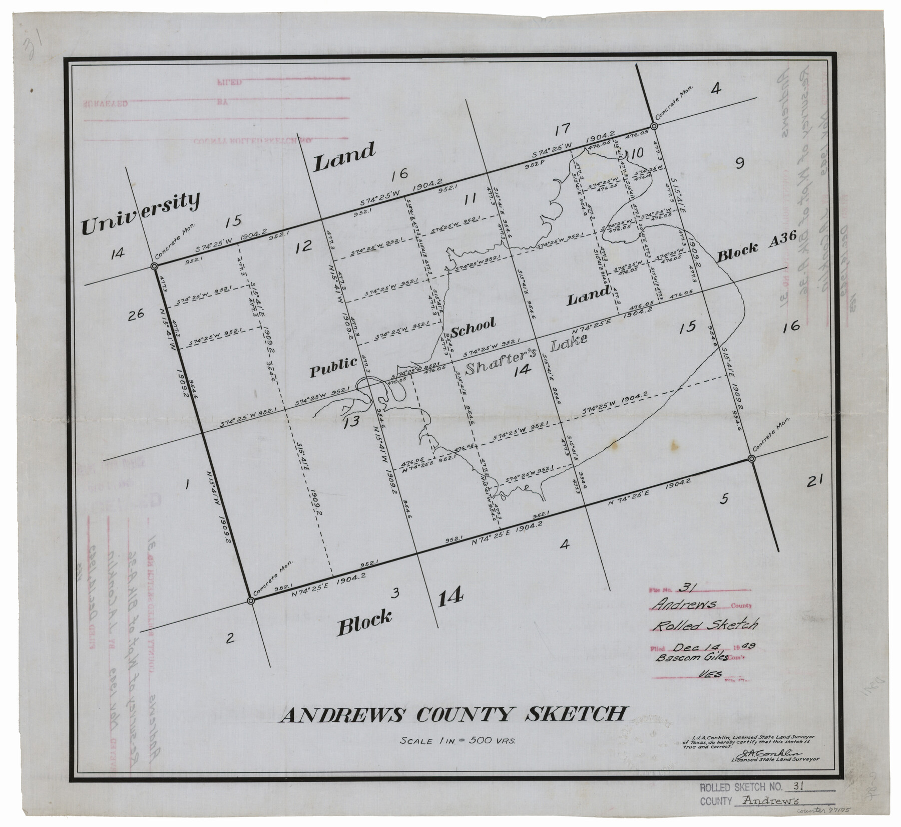
Andrews County Rolled Sketch 31
[Shafter's Lake and surrounding surveys]
-
Map/Doc
77175
-
Collection
General Map Collection
-
Object Dates
1949 (Survey Date)
1949/12/14 (File Date)
-
People and Organizations
J.A. Conklin (Surveyor/Engineer)
-
Counties
Andrews
-
Subjects
Surveying Rolled Sketch
-
Height x Width
18.3 x 19.9 inches
46.5 x 50.5 cm
-
Medium
linen, manuscript
-
Scale
1" = 500 varas
-
Features
Shafter's Lake
Part of: General Map Collection
Flight Mission No. DIX-6P, Frame 196, Aransas County

Print $20.00
- Digital $50.00
Flight Mission No. DIX-6P, Frame 196, Aransas County
1956
Size 18.9 x 22.6 inches
Map/Doc 83858
Ward County Rolled Sketch 27

Print $20.00
- Digital $50.00
Ward County Rolled Sketch 27
1982
Size 22.7 x 16.5 inches
Map/Doc 8166
Wheeler County Rolled Sketch 2

Print $20.00
- Digital $50.00
Wheeler County Rolled Sketch 2
1941
Size 44.0 x 22.4 inches
Map/Doc 10137
University Land in Hudspeth County showing Mineral Surveys in Blocks A, B, C, D, E, F, G, H, I, J, K, L, M, N

Print $40.00
- Digital $50.00
University Land in Hudspeth County showing Mineral Surveys in Blocks A, B, C, D, E, F, G, H, I, J, K, L, M, N
Size 39.7 x 48.4 inches
Map/Doc 2421
Hansford County

Print $20.00
- Digital $50.00
Hansford County
1878
Size 19.5 x 17.0 inches
Map/Doc 3623
Bowie County Rolled Sketch 3

Print $57.00
- Digital $50.00
Bowie County Rolled Sketch 3
1970
Size 10.0 x 15.3 inches
Map/Doc 42739
Presidio County Rolled Sketch 7

Print $40.00
- Digital $50.00
Presidio County Rolled Sketch 7
1875
Size 37.5 x 53.8 inches
Map/Doc 9762
Bexar County Sketch File 36

Print $14.00
- Digital $50.00
Bexar County Sketch File 36
1868
Size 8.8 x 7.6 inches
Map/Doc 14500
Concho County Working Sketch Graphic Index

Print $20.00
- Digital $50.00
Concho County Working Sketch Graphic Index
1947
Size 45.8 x 35.6 inches
Map/Doc 76503
Sutton County Working Sketch 23

Print $20.00
- Digital $50.00
Sutton County Working Sketch 23
1981
Size 17.3 x 27.1 inches
Map/Doc 62366
Real County Rolled Sketch 2

Print $40.00
- Digital $50.00
Real County Rolled Sketch 2
Size 36.9 x 66.6 inches
Map/Doc 9832
Young County Sketch File 11

Print $4.00
- Digital $50.00
Young County Sketch File 11
1877
Size 10.1 x 8.5 inches
Map/Doc 40874
You may also like
[Portions of Blocks T1, B, and T]
![90950, [Portions of Blocks T1, B, and T], Twichell Survey Records](https://historictexasmaps.com/wmedia_w700/maps/90950-1.tif.jpg)
Print $2.00
- Digital $50.00
[Portions of Blocks T1, B, and T]
1910
Size 13.8 x 4.3 inches
Map/Doc 90950
Webb County Sketch File 9b

Print $20.00
- Digital $50.00
Webb County Sketch File 9b
1930
Size 15.9 x 16.5 inches
Map/Doc 12620
Sutton County Rolled Sketch 53

Print $20.00
- Digital $50.00
Sutton County Rolled Sketch 53
1952
Size 23.4 x 15.5 inches
Map/Doc 7893
Sectional Map No. 5 of the lands and of the line of the Texas & Pacific Ry. Co. in part of El Paso County

Print $20.00
- Digital $50.00
Sectional Map No. 5 of the lands and of the line of the Texas & Pacific Ry. Co. in part of El Paso County
1885
Size 22.5 x 17.9 inches
Map/Doc 2305
Concho County Rolled Sketch 21

Print $20.00
- Digital $50.00
Concho County Rolled Sketch 21
1969
Size 38.3 x 43.5 inches
Map/Doc 8666
Dimmit County Sketch File 56

Print $20.00
- Digital $50.00
Dimmit County Sketch File 56
1939
Size 15.8 x 27.4 inches
Map/Doc 11360
Hamilton County Working Sketch 2

Print $20.00
- Digital $50.00
Hamilton County Working Sketch 2
1923
Size 12.9 x 15.7 inches
Map/Doc 63340
Mason County Boundary File 3a

Print $12.00
- Digital $50.00
Mason County Boundary File 3a
Size 8.9 x 8.2 inches
Map/Doc 56846
[Movements & Objectives of the 143rd & 144th Infantry and many other divisions and regiments, 1918] - Verso
![94139, [Movements & Objectives of the 143rd & 144th Infantry and many other divisions and regiments, 1918] - Verso, Non-GLO Digital Images](https://historictexasmaps.com/wmedia_w700/maps/94139-1.tif.jpg)
Print $40.00
[Movements & Objectives of the 143rd & 144th Infantry and many other divisions and regiments, 1918] - Verso
1918
Size 37.2 x 63.9 inches
Map/Doc 94139
Arroyo Colorado, La Feria Sheet

Print $40.00
- Digital $50.00
Arroyo Colorado, La Feria Sheet
1929
Size 24.6 x 58.5 inches
Map/Doc 65128
Armstrong County Boundary File 4

Print $2.00
- Digital $50.00
Armstrong County Boundary File 4
Size 10.2 x 8.8 inches
Map/Doc 50148
Orange County Rolled Sketch RG

Print $40.00
- Digital $50.00
Orange County Rolled Sketch RG
1919
Size 32.7 x 61.2 inches
Map/Doc 9654