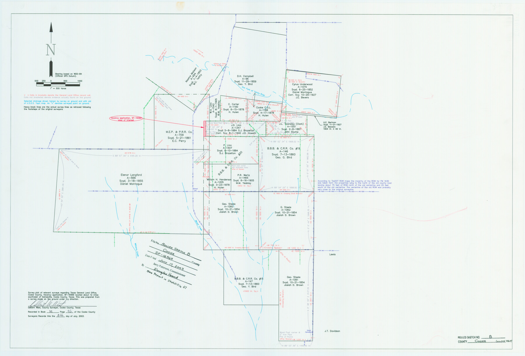
Cooke County Rolled Sketch 8
Survey plat of relevant surveys regarding Texas General Land Office, Cooke County, vacancy application SF-16569
-
Map/Doc
78649
-
Collection
General Map Collection
-
Object Dates
2003/7/17 (File Date)
2003/7/8 (Creation Date)
-
People and Organizations
Jerry E. Patterson (GLO Commissioner)
Delbert W. West (Surveyor/Engineer)
-
Counties
Cooke
-
Subjects
Surveying Rolled Sketch
-
Height x Width
24.5 x 36.2 inches
62.2 x 91.9 cm
-
Medium
mylar, print
-
Scale
1" = 500 varas
-
Comments
See Cooke County Sketch File 47 (78650) for surveyor’s report.
Related maps
Cooke County Sketch File 47

Print $24.00
- Digital $50.00
Cooke County Sketch File 47
2003
Size 26.6 x 18.4 inches
Map/Doc 78650
Part of: General Map Collection
Gaines County Working Sketch 37

Print $20.00
- Digital $50.00
Gaines County Working Sketch 37
Size 21.5 x 16.6 inches
Map/Doc 69337
Erath County Working Sketch 24

Print $20.00
- Digital $50.00
Erath County Working Sketch 24
1967
Size 41.5 x 39.3 inches
Map/Doc 69105
Duval County Working Sketch 36

Print $20.00
- Digital $50.00
Duval County Working Sketch 36
1957
Size 36.1 x 26.0 inches
Map/Doc 68760
Outer Continental Shelf Leasing Maps (Louisiana Offshore Operations)

Print $20.00
- Digital $50.00
Outer Continental Shelf Leasing Maps (Louisiana Offshore Operations)
1971
Size 18.7 x 13.9 inches
Map/Doc 76102
Angelina County Working Sketch 48

Print $20.00
- Digital $50.00
Angelina County Working Sketch 48
1980
Size 33.5 x 38.9 inches
Map/Doc 67131
Cherokee County Sketch File 14

Print $4.00
- Digital $50.00
Cherokee County Sketch File 14
1860
Size 8.0 x 5.9 inches
Map/Doc 18147
Travis County Rolled Sketch 61

Print $20.00
- Digital $50.00
Travis County Rolled Sketch 61
2023
Size 36.0 x 24.0 inches
Map/Doc 97184
[Surveys possibly in Austin County]
![78356, [Surveys possibly in Austin County], General Map Collection](https://historictexasmaps.com/wmedia_w700/maps/78356.tif.jpg)
Print $3.00
- Digital $50.00
[Surveys possibly in Austin County]
Size 17.0 x 9.6 inches
Map/Doc 78356
Portion of States Submerged Area in Matagorda Bay

Print $20.00
- Digital $50.00
Portion of States Submerged Area in Matagorda Bay
1922
Size 15.2 x 14.8 inches
Map/Doc 2953
Galveston County NRC Article 33.136 Sketch 78

Print $24.00
- Digital $50.00
Galveston County NRC Article 33.136 Sketch 78
2015
Size 36.0 x 24.0 inches
Map/Doc 95129
Wise County Rolled Sketch 8

Print $20.00
- Digital $50.00
Wise County Rolled Sketch 8
Size 24.0 x 36.0 inches
Map/Doc 93554
Real County Working Sketch 59

Print $20.00
- Digital $50.00
Real County Working Sketch 59
1962
Size 27.4 x 40.7 inches
Map/Doc 71951
You may also like
Wise County Sketch File 46

Print $20.00
- Digital $50.00
Wise County Sketch File 46
Size 24.7 x 18.5 inches
Map/Doc 12701
Nolan County Rolled Sketch 2

Print $20.00
- Digital $50.00
Nolan County Rolled Sketch 2
1956
Size 27.7 x 35.0 inches
Map/Doc 6860
Gregg County Boundary File 2

Print $8.00
- Digital $50.00
Gregg County Boundary File 2
Size 8.8 x 3.7 inches
Map/Doc 53984
Map of Liberty County

Print $40.00
- Digital $50.00
Map of Liberty County
1841
Size 60.1 x 37.3 inches
Map/Doc 1951
Panola County Working Sketch 4

Print $20.00
- Digital $50.00
Panola County Working Sketch 4
1938
Map/Doc 71413
Sectional map of Texas traversed by the Missouri, Kansas & Texas Railway, showing the crops adapted to each section, with the elevation and annual rainfall

Print $20.00
- Digital $50.00
Sectional map of Texas traversed by the Missouri, Kansas & Texas Railway, showing the crops adapted to each section, with the elevation and annual rainfall
1904
Size 21.9 x 23.0 inches
Map/Doc 95815
Coleman County

Print $20.00
- Digital $50.00
Coleman County
1862
Size 22.5 x 21.6 inches
Map/Doc 3414
Presidio County Working Sketch 78

Print $20.00
- Digital $50.00
Presidio County Working Sketch 78
1965
Size 24.8 x 25.1 inches
Map/Doc 71755
Robertson County Sketch File 10 (1)

Print $3.00
- Digital $50.00
Robertson County Sketch File 10 (1)
Size 13.0 x 10.4 inches
Map/Doc 43369
Angelina County Sketch File 14

Print $2.00
- Digital $50.00
Angelina County Sketch File 14
Size 7.6 x 6.9 inches
Map/Doc 12959
Goliad County Sketch File 11

Print $40.00
- Digital $50.00
Goliad County Sketch File 11
Size 13.4 x 12.5 inches
Map/Doc 24228
Plan of the City of Galveston, Texas

Print $20.00
- Digital $50.00
Plan of the City of Galveston, Texas
1845
Size 18.4 x 27.8 inches
Map/Doc 62970