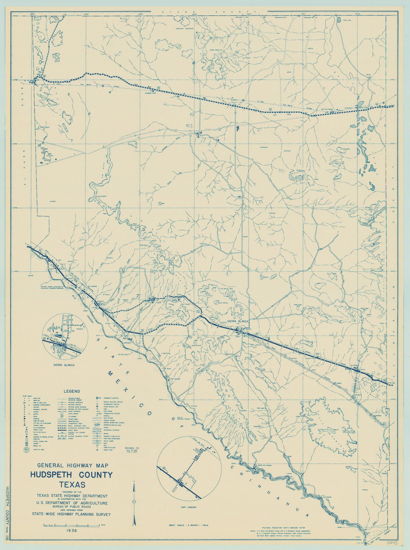
General Highway Map, Hudspeth County, Texas
-
Map/Doc
79135
-
Collection
Texas State Library and Archives
-
Object Dates
1940 (Creation Date)
-
People and Organizations
Texas State Highway Department (Publisher)
-
Counties
Hudspeth
-
Subjects
County
-
Height x Width
24.7 x 18.4 inches
62.7 x 46.7 cm
-
Comments
Prints available courtesy of the Texas State Library and Archives.
More info can be found here: TSLAC Map 04898
Part of: Texas State Library and Archives
Revised Edition of Murphy and Bolanz Official Map of the City of Dallas and Suburbs

Print $20.00
Revised Edition of Murphy and Bolanz Official Map of the City of Dallas and Suburbs
1891
Size 38.1 x 30.8 inches
Map/Doc 76275
General Highway Map. Detail of Cities and Towns in Bell County, Texas [Temple]
![79368, General Highway Map. Detail of Cities and Towns in Bell County, Texas [Temple], Texas State Library and Archives](https://historictexasmaps.com/wmedia_w700/maps/79368.tif.jpg)
Print $20.00
General Highway Map. Detail of Cities and Towns in Bell County, Texas [Temple]
1961
Size 18.2 x 25.0 inches
Map/Doc 79368
General Highway Map, San Jacinto County, Texas

Print $20.00
General Highway Map, San Jacinto County, Texas
1940
Size 24.9 x 18.4 inches
Map/Doc 79236
Map of New Braunfels, Comal County, Texas

Print $20.00
Map of New Braunfels, Comal County, Texas
1868
Size 19.0 x 25.1 inches
Map/Doc 76282
General Highway Map. Detail of Cities and Towns in Bexar County, Texas. City Map of San Antonio, Alamo Heights, Olmos Park, Terrell Hills, Castle Hills, Balcones Heights, and vicinity, Bexar County, Texas

Print $20.00
General Highway Map. Detail of Cities and Towns in Bexar County, Texas. City Map of San Antonio, Alamo Heights, Olmos Park, Terrell Hills, Castle Hills, Balcones Heights, and vicinity, Bexar County, Texas
1961
Size 25.1 x 18.2 inches
Map/Doc 79372
General Highway Map, Val Verde County, Texas

Print $20.00
General Highway Map, Val Verde County, Texas
1940
Size 25.0 x 18.4 inches
Map/Doc 79266
General Highway Map, Burnet County, Texas

Print $20.00
General Highway Map, Burnet County, Texas
1940
Size 18.4 x 25.0 inches
Map/Doc 79035
General Highway Map, Jim Hogg County, Texas

Print $20.00
General Highway Map, Jim Hogg County, Texas
1940
Size 24.8 x 18.5 inches
Map/Doc 79146
General Highway Map, Houston County, Texas

Print $20.00
General Highway Map, Houston County, Texas
1940
Size 25.0 x 18.6 inches
Map/Doc 79132
General Highway Map, Liberty County, Texas

Print $20.00
General Highway Map, Liberty County, Texas
1940
Size 24.6 x 18.3 inches
Map/Doc 79173
General Highway Map, Harrison County, Texas

Print $20.00
General Highway Map, Harrison County, Texas
1940
Size 18.2 x 24.8 inches
Map/Doc 79121
General Highway Map, Brooks County, Texas

Print $20.00
General Highway Map, Brooks County, Texas
1940
Size 18.5 x 25.0 inches
Map/Doc 79030
You may also like
Orange County Rolled Sketch 21

Print $20.00
- Digital $50.00
Orange County Rolled Sketch 21
Size 34.3 x 42.5 inches
Map/Doc 9646
Goliad County Working Sketch 18

Print $20.00
- Digital $50.00
Goliad County Working Sketch 18
1949
Size 31.2 x 39.4 inches
Map/Doc 63208
Nueces County NRC Article 33.136 Sketch 25

Print $36.00
Nueces County NRC Article 33.136 Sketch 25
2025
Map/Doc 97513
Angelina County Working Sketch 37

Print $20.00
- Digital $50.00
Angelina County Working Sketch 37
1958
Size 25.7 x 19.1 inches
Map/Doc 67120
Garza County Sketch File 24

Print $8.00
- Digital $50.00
Garza County Sketch File 24
Size 9.1 x 7.7 inches
Map/Doc 24083
Harris County Working Sketch 23

Print $20.00
- Digital $50.00
Harris County Working Sketch 23
1926
Size 14.0 x 20.0 inches
Map/Doc 65915
Smith County Sketch File 5

Print $6.00
- Digital $50.00
Smith County Sketch File 5
1857
Size 8.4 x 7.8 inches
Map/Doc 36754
Stonewall County Working Sketch 12

Print $20.00
- Digital $50.00
Stonewall County Working Sketch 12
1950
Size 27.9 x 27.9 inches
Map/Doc 62319
Real County Working Sketch 87

Print $20.00
- Digital $50.00
Real County Working Sketch 87
1988
Size 30.9 x 29.6 inches
Map/Doc 71979
[Surveys made in Peters Colony by Thomas Leckie]
![1984, [Surveys made in Peters Colony by Thomas Leckie], General Map Collection](https://historictexasmaps.com/wmedia_w700/maps/1984.tif.jpg)
Print $20.00
- Digital $50.00
[Surveys made in Peters Colony by Thomas Leckie]
1859
Size 15.1 x 13.4 inches
Map/Doc 1984
Armstrong County Boundary File 3

Print $14.00
- Digital $50.00
Armstrong County Boundary File 3
Size 11.3 x 8.8 inches
Map/Doc 50141
Brewster County Rolled Sketch 114

Print $20.00
- Digital $50.00
Brewster County Rolled Sketch 114
1964
Size 11.6 x 18.5 inches
Map/Doc 5275