Webb County Rolled Sketch 20
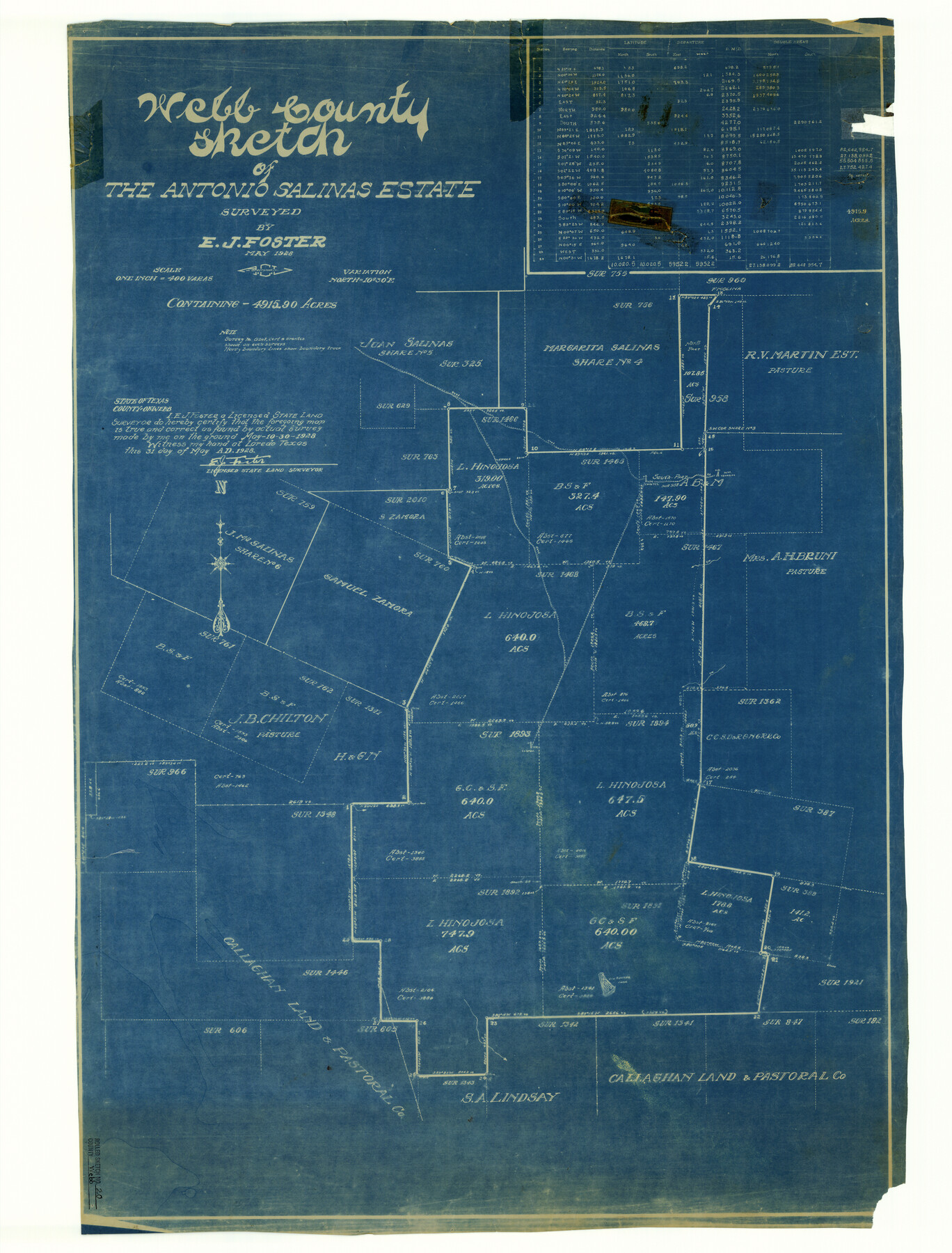
Webb County sketch of the Antonio Salinas estate
- 
                          Map/Doc8182
- 
                            CollectionGeneral Map Collection
- 
                            Object Dates1928/5/31 (Creation Date)
- 
                            People and OrganizationsE.J. Foster (Surveyor/Engineer)
- 
                            CountiesWebb
- 
                            SubjectsSurveying Rolled Sketch
- 
                            Height x Width38.1 x 29.0 inches96.8 x 73.7 cm
- 
                            Mediumblueprint/diazo
- 
                            Scale1" = 400 varas
Part of: General Map Collection
            Crockett County Working Sketch 89


                                            Print $20.00                    
                                             -                         Digital $50.00                                    
                Crockett County Working Sketch 89
1978
Size 36.4 x 44.5 inches
                                Map/Doc 68422
            
            Corpus Christi Bay in Nueces County, showing Subdivision for Mineral Development


                                            Print $40.00                    
                                             -                         Digital $50.00                                    
                Corpus Christi Bay in Nueces County, showing Subdivision for Mineral Development
1950
Size 48.4 x 36.0 inches
                                Map/Doc 1917
            
            El Paso County Rolled Sketch 52


                                            Print $20.00                    
                                             -                         Digital $50.00                                    
                El Paso County Rolled Sketch 52
1929
Size 18.5 x 24.4 inches
                                Map/Doc 5838
            
            Pecos County Sketch File 52


                                            Print $10.00                    
                                             -                         Digital $50.00                                    
                Pecos County Sketch File 52
Size 8.6 x 3.8 inches
                                Map/Doc 33781
            
            Calhoun County Rolled Sketch 30


                                            Print $20.00                    
                                             -                         Digital $50.00                                    
                Calhoun County Rolled Sketch 30
1974
Size 18.6 x 27.6 inches
                                Map/Doc 5491
            
            [Beaumont, Sour Lake and Western Ry. Right of Way and Alignment - Frisco]
            
                                    ![64116, [Beaumont, Sour Lake and Western Ry. Right of Way and Alignment - Frisco], General Map Collection](https://historictexasmaps.com/wmedia_w700/maps/64116.tif.jpg) 


    ![64116, [Beaumont, Sour Lake and Western Ry. Right of Way and Alignment - Frisco], General Map Collection](https://historictexasmaps.com/wmedia_w700/maps/64116.tif.jpg) 
                                
            
                                            Print $20.00                    
                                             -                         Digital $50.00                                    
                [Beaumont, Sour Lake and Western Ry. Right of Way and Alignment - Frisco]
1910
Size 20.3 x 46.1 inches
                                Map/Doc 64116
            
            In the Supreme Court of the United States, The State of Oklahoma, Complainant vs. The State of Texas, Defendant, The United States of America, Intervener, Red River Valley, Texas and Oklahoma Between the 98th and 100th Meridians in Five Sheets, 1921


                                            Print $40.00                    
                                             -                         Digital $50.00                                    
                In the Supreme Court of the United States, The State of Oklahoma, Complainant vs. The State of Texas, Defendant, The United States of America, Intervener, Red River Valley, Texas and Oklahoma Between the 98th and 100th Meridians in Five Sheets, 1921
1921
Size 38.6 x 60.0 inches
                                Map/Doc 75276
            
            Callahan County Sketch File 7


                                            Print $18.00                    
                                             -                         Digital $50.00                                    
                Callahan County Sketch File 7
Size 10.8 x 8.9 inches
                                Map/Doc 35863
            
            Houston County Working Sketch 7


                                            Print $20.00                    
                                             -                         Digital $50.00                                    
                Houston County Working Sketch 7
1935
Size 24.7 x 36.8 inches
                                Map/Doc 66237
            
            Callahan County Sketch File 9


                                            Print $40.00                    
                                             -                         Digital $50.00                                    
                Callahan County Sketch File 9
1880
Size 16.8 x 14.3 inches
                                Map/Doc 35871
            
            Brewster County Rolled Sketch 98


                                            Print $20.00                    
                                             -                         Digital $50.00                                    
                Brewster County Rolled Sketch 98
1952
Size 29.3 x 38.0 inches
                                Map/Doc 8508
            
            Amistad International Reservoir on Rio Grande 93


                                            Print $20.00                    
                                             -                         Digital $50.00                                    
                Amistad International Reservoir on Rio Grande 93
1950
Size 28.5 x 40.7 inches
                                Map/Doc 75523
            You may also like
            Red River County Working Sketch 25


                                            Print $20.00                    
                                             -                         Digital $50.00                                    
                Red River County Working Sketch 25
1959
Size 23.0 x 22.2 inches
                                Map/Doc 72008
            
            Live Oak County Sketch File 3


                                            Print $22.00                    
                                             -                         Digital $50.00                                    
                Live Oak County Sketch File 3
1848
Size 12.6 x 16.1 inches
                                Map/Doc 30255
            
            San Patricio County, Texas


                                            Print $20.00                    
                                             -                         Digital $50.00                                    
                San Patricio County, Texas
1879
Size 18.1 x 22.8 inches
                                Map/Doc 611
            
            Nueces County Aerial Photograph Index Sheet 5


                                            Print $20.00                    
                                             -                         Digital $50.00                                    
                Nueces County Aerial Photograph Index Sheet 5
1956
Size 19.5 x 23.4 inches
                                Map/Doc 83738
            
            Hardin County Sketch File 49


                                            Print $4.00                    
                                             -                         Digital $50.00                                    
                Hardin County Sketch File 49
1904
Size 14.5 x 8.8 inches
                                Map/Doc 25202
            
            San Saba County Working Sketch Graphic Index


                                            Print $20.00                    
                                             -                         Digital $50.00                                    
                San Saba County Working Sketch Graphic Index
1918
Size 46.5 x 41.1 inches
                                Map/Doc 76693
            
            Collin County Boundary File 18c


                                            Print $12.00                    
                                             -                         Digital $50.00                                    
                Collin County Boundary File 18c
Size 12.9 x 8.1 inches
                                Map/Doc 51733
            
            Reagan County Sketch File 10


                                            Print $40.00                    
                                             -                         Digital $50.00                                    
                Reagan County Sketch File 10
1928
Size 13.7 x 14.2 inches
                                Map/Doc 34989
            
            San Patricio County Working Sketch 10


                                            Print $20.00                    
                                             -                         Digital $50.00                                    
                San Patricio County Working Sketch 10
1939
Size 28.1 x 32.6 inches
                                Map/Doc 63772
            
            Denton County Sketch File 13


                                            Print $12.00                    
                                             -                         Digital $50.00                                    
                Denton County Sketch File 13
1856
Size 12.3 x 7.9 inches
                                Map/Doc 20713
            
            Lampasas County Sketch File 4


                                            Print $4.00                    
                                             -                         Digital $50.00                                    
                Lampasas County Sketch File 4
1861
Size 12.3 x 8.2 inches
                                Map/Doc 29394
            
            [Sketch showing H. & G. N. Block A on the north side of the Canadian River and H. & T. C. Block 46 on the south side of the Canadian River]
            
                                    ![91763, [Sketch showing H. & G. N. Block A on the north side of the Canadian River and H. & T. C. Block 46 on the south side of the Canadian River], Twichell Survey Records](https://historictexasmaps.com/wmedia_w700/maps/91763-1.tif.jpg) 


    ![91763, [Sketch showing H. & G. N. Block A on the north side of the Canadian River and H. & T. C. Block 46 on the south side of the Canadian River], Twichell Survey Records](https://historictexasmaps.com/wmedia_w700/maps/91763-1.tif.jpg) 
                                
            
                                            Print $20.00                    
                                             -                         Digital $50.00                                    
                [Sketch showing H. & G. N. Block A on the north side of the Canadian River and H. & T. C. Block 46 on the south side of the Canadian River]
1927
Size 25.1 x 11.2 inches
                                Map/Doc 91763
            