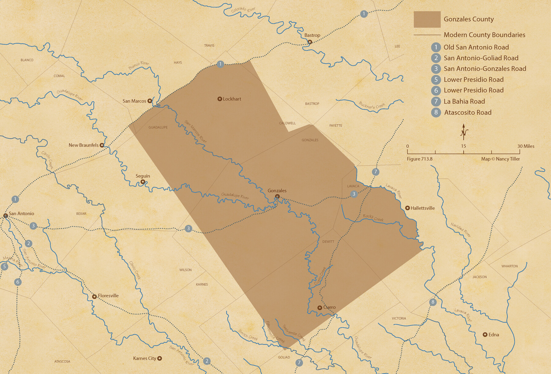
The Republic County of Gonzales. December 29, 1845
Figure No. 713.8 from 'A Boundary Atlas of Texas, 1821-1845' by Jim Tiller
-
Map/Doc
96160
-
Collection
Nancy and Jim Tiller Digital Collection
-
Object Dates
2020/1/1 (Creation Date)
-
People and Organizations
Jim Tiller (Author)
Nancy Tiller (Cartographer)
Gang Gong (GIS Professional)
-
Counties
Gonzales
-
Subjects
Atlas County Republic of Texas Texas Boundaries
-
Height x Width
14.7 x 21.7 inches
37.3 x 55.1 cm
-
Medium
digital image
-
Comments
To purchase a digital PDF copy of "A Boundary Atlas of Texas, 1821-1845" see 96437.
Part of: Nancy and Jim Tiller Digital Collection
The Mexican Municipality of San Augustine. Created March 6, 1834

Print $20.00
The Mexican Municipality of San Augustine. Created March 6, 1834
2020
Size 24.1 x 21.7 inches
Map/Doc 96032
The Republic County of Montgomery. December 31, 1838

Print $20.00
The Republic County of Montgomery. December 31, 1838
2020
Size 19.9 x 21.7 inches
Map/Doc 96236
The Land Offices. No. 10, Bexar, December 22, 1836

Print $20.00
The Land Offices. No. 10, Bexar, December 22, 1836
2020
Size 19.2 x 16.2 inches
Map/Doc 96423
The Republic County of Rusk. February 1, 1845

Print $20.00
The Republic County of Rusk. February 1, 1845
2020
Size 19.1 x 21.7 inches
Map/Doc 96267
DeWitt Empresario Colony. April 15, 1825

Print $20.00
DeWitt Empresario Colony. April 15, 1825
2020
Size 18.1 x 21.7 inches
Map/Doc 95991
The Republic County of Gonzales. Boundaries Defined, December 14, 1837

Print $20.00
The Republic County of Gonzales. Boundaries Defined, December 14, 1837
2020
Size 14.7 x 21.7 inches
Map/Doc 96153
The Chief Justice County of Goliad. Proposed, No Date

Print $20.00
The Chief Justice County of Goliad. Proposed, No Date
2020
Size 14.7 x 21.7 inches
Map/Doc 96046
The Republic County of Matagorda. Proposed, Late Fall 1837-January 1, 1838

Print $20.00
The Republic County of Matagorda. Proposed, Late Fall 1837-January 1, 1838
2020
Size 21.0 x 21.7 inches
Map/Doc 96215
The Republic County of Red River. Spring 1842

Print $20.00
The Republic County of Red River. Spring 1842
2020
Size 21.0 x 21.7 inches
Map/Doc 96254
From Citizens Living in What Was to Become Fannin County for the Creation of a New County (Unnamed), Undated

Print $20.00
From Citizens Living in What Was to Become Fannin County for the Creation of a New County (Unnamed), Undated
2020
Size 17.6 x 21.7 inches
Map/Doc 96400
The Republic County of Montgomery. December 18, 1837

Print $20.00
The Republic County of Montgomery. December 18, 1837
2020
Size 19.9 x 21.7 inches
Map/Doc 96235
The Republic County of Jefferson. Boundaries Defined, December 21, 1837

Print $20.00
The Republic County of Jefferson. Boundaries Defined, December 21, 1837
2020
Size 22.6 x 21.7 inches
Map/Doc 96197
You may also like
Fort Bend County Rolled Sketch 17

Print $20.00
- Digital $50.00
Fort Bend County Rolled Sketch 17
1997
Size 28.0 x 38.5 inches
Map/Doc 5901
Fisher County Sketch File 20

Print $66.00
- Digital $50.00
Fisher County Sketch File 20
Size 9.3 x 9.1 inches
Map/Doc 22616
Nacogdoches County Sketch File 3

Print $8.00
- Digital $50.00
Nacogdoches County Sketch File 3
Size 6.5 x 8.2 inches
Map/Doc 32237
Controlled Mosaic by Jack Amman Photogrammetric Engineers, Inc - Sheet 21

Print $20.00
- Digital $50.00
Controlled Mosaic by Jack Amman Photogrammetric Engineers, Inc - Sheet 21
1954
Size 20.0 x 24.0 inches
Map/Doc 83470
La Salle County Working Sketch 9

Print $20.00
- Digital $50.00
La Salle County Working Sketch 9
1925
Size 21.2 x 15.6 inches
Map/Doc 70310
Haskell County Working Sketch 12

Print $20.00
- Digital $50.00
Haskell County Working Sketch 12
1979
Size 39.3 x 44.2 inches
Map/Doc 66070
Guadalupe County Sketch File 15b

Print $4.00
- Digital $50.00
Guadalupe County Sketch File 15b
1873
Size 10.3 x 8.4 inches
Map/Doc 24691
San Jacinto River and Tributaries, Texas - Survey of 1939

Print $20.00
- Digital $50.00
San Jacinto River and Tributaries, Texas - Survey of 1939
1939
Size 27.7 x 40.4 inches
Map/Doc 60306
Flight Mission No. DCL-3C, Frame 106, Kenedy County

Print $20.00
- Digital $50.00
Flight Mission No. DCL-3C, Frame 106, Kenedy County
1943
Size 18.7 x 22.3 inches
Map/Doc 85801
Palo Pinto County Working Sketch 14

Print $20.00
- Digital $50.00
Palo Pinto County Working Sketch 14
1960
Size 27.2 x 27.4 inches
Map/Doc 71397
Webb County Rolled Sketch 38

Print $20.00
- Digital $50.00
Webb County Rolled Sketch 38
1940
Size 22.2 x 16.0 inches
Map/Doc 8193
Presidio County Working Sketch 74

Print $20.00
- Digital $50.00
Presidio County Working Sketch 74
1962
Size 45.9 x 35.2 inches
Map/Doc 71751