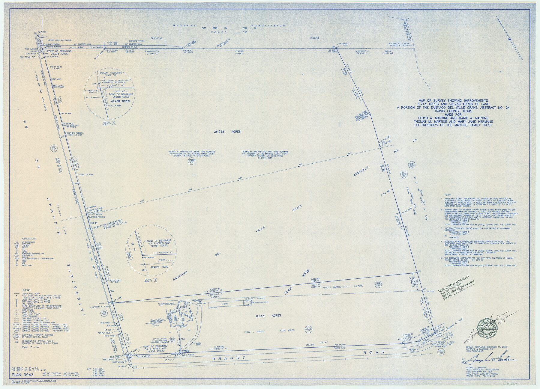
Travis County State Real Property Sketch 9
A survey of 6.713 acres and 26.238 acres of land showing improvements on a portion of the Santiago Del Valle Grant, A - 24
State Real Property Sketch L - 38
-
Map/Doc
82560
-
Collection
General Map Collection
-
Object Dates
12/12/2002 (Creation Date)
6/16/2002 (File Date)
-
People and Organizations
George L. Sanders (Surveyor/Engineer)
-
Counties
Travis
-
Subjects
State Real Property
-
Height x Width
30.6 x 42.5 inches
77.7 x 108.0 cm
-
Scale
1" = 50 feet
-
Comments
Surveys located about eight and one half miles South 22 degrees West of Austin, Texas.
Part of: General Map Collection
Roberts County Sketch File 10

Print $32.00
- Digital $50.00
Roberts County Sketch File 10
2016
Size 11.0 x 8.5 inches
Map/Doc 94070
Van Zandt County Sketch File 49

Print $2.00
- Digital $50.00
Van Zandt County Sketch File 49
1990
Size 11.3 x 8.9 inches
Map/Doc 39510
Eastland County Working Sketch 60a

Print $20.00
- Digital $50.00
Eastland County Working Sketch 60a
1988
Size 45.1 x 39.0 inches
Map/Doc 78209

Van Zandt County Working Sketch 5

Print $20.00
- Digital $50.00
Van Zandt County Working Sketch 5
1940
Size 37.2 x 25.5 inches
Map/Doc 72254
Flight Mission No. CLL-3N, Frame 13, Willacy County

Print $20.00
- Digital $50.00
Flight Mission No. CLL-3N, Frame 13, Willacy County
1954
Size 18.4 x 22.1 inches
Map/Doc 87079
Menard County Boundary File 9

Print $4.00
- Digital $50.00
Menard County Boundary File 9
Size 9.9 x 8.1 inches
Map/Doc 57094
[Sketch for Mineral Application 1112 - Colorado River, H. E. Chambers]
![65642, [Sketch for Mineral Application 1112 - Colorado River, H. E. Chambers], General Map Collection](https://historictexasmaps.com/wmedia_w700/maps/65642.tif.jpg)
Print $20.00
- Digital $50.00
[Sketch for Mineral Application 1112 - Colorado River, H. E. Chambers]
1918
Size 17.1 x 28.4 inches
Map/Doc 65642
Comal County Working Sketch 6

Print $20.00
- Digital $50.00
Comal County Working Sketch 6
1950
Size 25.1 x 24.2 inches
Map/Doc 68172
Flight Mission No. CLL-3N, Frame 10, Willacy County

Print $20.00
- Digital $50.00
Flight Mission No. CLL-3N, Frame 10, Willacy County
1954
Size 18.5 x 22.2 inches
Map/Doc 87076
Clay County Working Sketch 9

Print $20.00
- Digital $50.00
Clay County Working Sketch 9
1938
Size 37.5 x 29.4 inches
Map/Doc 68032
Henderson County Working Sketch 23

Print $20.00
- Digital $50.00
Henderson County Working Sketch 23
1951
Size 28.2 x 24.2 inches
Map/Doc 66156
You may also like
Edwards County

Print $40.00
- Digital $50.00
Edwards County
1900
Size 56.4 x 27.3 inches
Map/Doc 87471
Aransas County NRC Article 33.136 Sketch 2

Print $26.00
- Digital $50.00
Aransas County NRC Article 33.136 Sketch 2
2001
Size 18.6 x 24.2 inches
Map/Doc 61643
Galveston County Boundary File 32

Print $52.00
- Digital $50.00
Galveston County Boundary File 32
Size 16.7 x 13.6 inches
Map/Doc 53658
San Patricio County Sketch File 49

Print $84.00
- Digital $50.00
San Patricio County Sketch File 49
1934
Size 9.1 x 11.4 inches
Map/Doc 36329
Flight Mission No. CRE-1R, Frame 136, Jackson County

Print $20.00
- Digital $50.00
Flight Mission No. CRE-1R, Frame 136, Jackson County
1956
Size 16.0 x 15.9 inches
Map/Doc 85344
King County Rolled Sketch 10

Print $20.00
- Digital $50.00
King County Rolled Sketch 10
Size 38.9 x 33.7 inches
Map/Doc 6532
Grayson County Sketch File 23

Print $4.00
- Digital $50.00
Grayson County Sketch File 23
1872
Size 9.1 x 10.3 inches
Map/Doc 24503
Crosby County Sketch File 35

Print $4.00
- Digital $50.00
Crosby County Sketch File 35
Size 8.5 x 12.1 inches
Map/Doc 20106
Sabine River, Merrill Lake Sheet

Print $20.00
- Digital $50.00
Sabine River, Merrill Lake Sheet
1933
Size 26.4 x 43.6 inches
Map/Doc 65137
Stonewall County Working Sketch 14

Print $20.00
- Digital $50.00
Stonewall County Working Sketch 14
1951
Size 22.2 x 37.1 inches
Map/Doc 62321

[Jacob Masters league and those adjoining and Surveys on Elkhart Creek]
![183, [Jacob Masters league and those adjoining and Surveys on Elkhart Creek], General Map Collection](https://historictexasmaps.com/wmedia_w700/maps/183.tif.jpg)
Print $20.00
- Digital $50.00
[Jacob Masters league and those adjoining and Surveys on Elkhart Creek]
1846
Size 20.3 x 8.0 inches
Map/Doc 183