San Patricio County Rolled Sketch 53A-53C
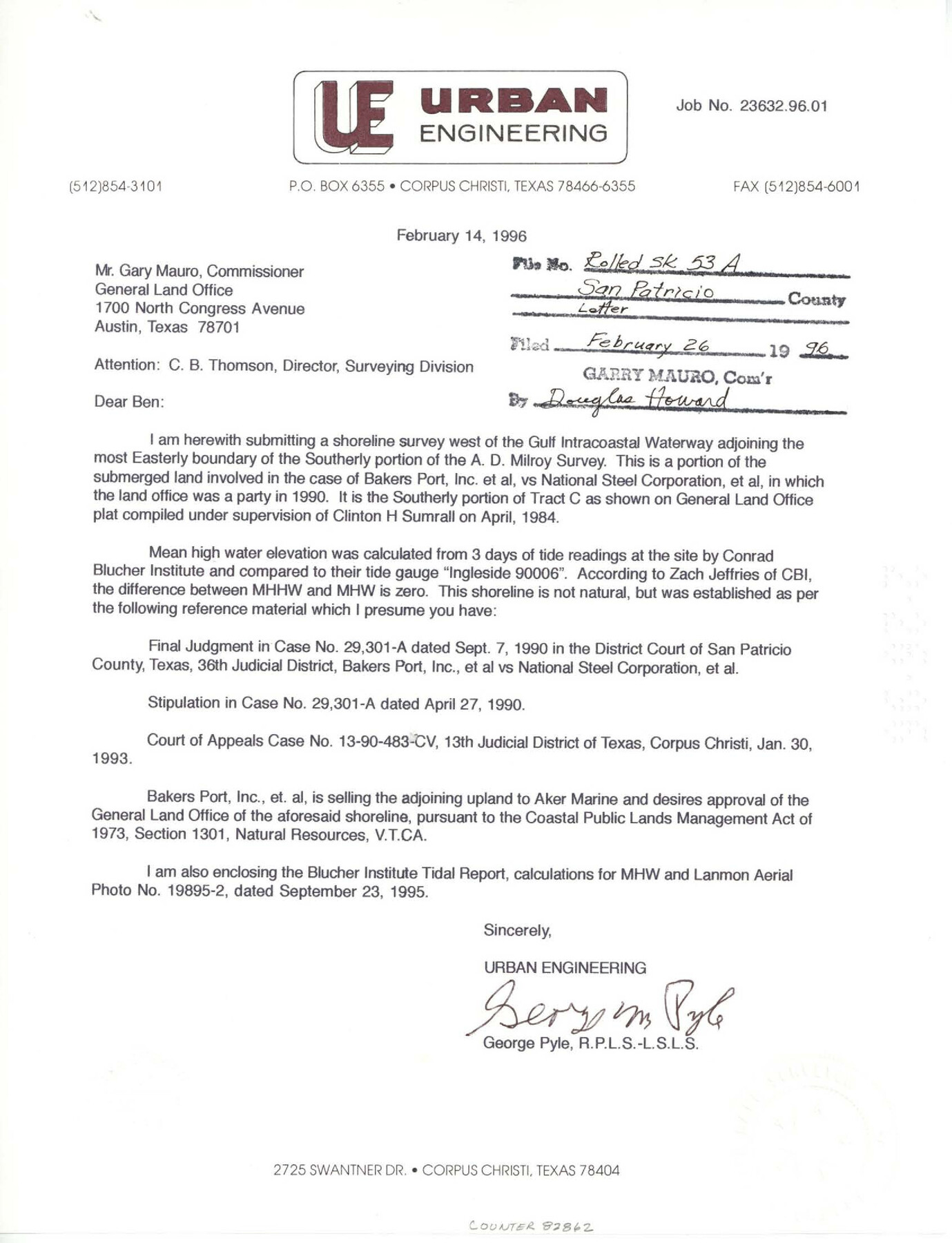
[Correspondence, plat, and data sheets relating to shoreline survey of west of the Gulf Intracoastal Waterway adjoining the most easterly boundary of the southerly portion of the A.D. Milroy survey]
- 
                          Map/Doc82862
- 
                            CollectionGeneral Map Collection
- 
                            Object Dates1996/2/14 (Creation Date)1996/2/26 (File Date)
- 
                            People and OrganizationsGeorge M. Pyle (Surveyor/Engineer)
- 
                            CountiesSan Patricio
- 
                            SubjectsSurveying Rolled Sketch
- 
                            Height x Width11.0 x 8.5 inches27.9 x 21.6 cm
- 
                            Mediummulti-page, multi-format
Part of: General Map Collection
            Matagorda County Rolled Sketch 31


                                            Print $187.00                    
                                             -                         Digital $50.00                                    
                Matagorda County Rolled Sketch 31
Size 10.6 x 15.5 inches
                                Map/Doc 46654
            
            Edwards County Working Sketch 127


                                            Print $20.00                    
                                             -                         Digital $50.00                                    
                Edwards County Working Sketch 127
1980
Size 21.0 x 24.1 inches
                                Map/Doc 69003
            
            Brewster County Rolled Sketch 85


                                            Print $20.00                    
                                             -                         Digital $50.00                                    
                Brewster County Rolled Sketch 85
1946
Size 30.4 x 22.8 inches
                                Map/Doc 5246
            
            Nacogdoches County Sketch File 16


                                            Print $20.00                    
                                             -                         Digital $50.00                                    
                Nacogdoches County Sketch File 16
1945
Size 24.6 x 18.5 inches
                                Map/Doc 42155
            
            Ward County Working Sketch 15


                                            Print $20.00                    
                                             -                         Digital $50.00                                    
                Ward County Working Sketch 15
Size 38.7 x 40.4 inches
                                Map/Doc 72321
            
            Crane County Sketch File 30


                                            Print $40.00                    
                                             -                         Digital $50.00                                    
                Crane County Sketch File 30
1933
Size 14.0 x 8.4 inches
                                Map/Doc 19610
            
            Glasscock County Working Sketch 9


                                            Print $40.00                    
                                             -                         Digital $50.00                                    
                Glasscock County Working Sketch 9
1957
Size 77.9 x 25.5 inches
                                Map/Doc 63182
            
            Montgomery County Working Sketch 69


                                            Print $20.00                    
                                             -                         Digital $50.00                                    
                Montgomery County Working Sketch 69
1973
Size 27.3 x 37.7 inches
                                Map/Doc 71176
            
            Angelina County Sketch File 23


                                            Print $20.00                    
                                             -                         Digital $50.00                                    
                Angelina County Sketch File 23
Size 13.5 x 8.1 inches
                                Map/Doc 13053
            
            Flight Mission No. BRA-8M, Frame 67, Jefferson County


                                            Print $20.00                    
                                             -                         Digital $50.00                                    
                Flight Mission No. BRA-8M, Frame 67, Jefferson County
1953
Size 18.8 x 22.5 inches
                                Map/Doc 85587
            
            [Abstract Numbering Register - Donley through Karnes]
            
                                    ![82966, [Abstract Numbering Register - Donley through Karnes], General Map Collection](https://historictexasmaps.com/wmedia_w700/pdf_converted_jpg/qi_pdf_thumbnail_30613.jpg) 


    ![82966, [Abstract Numbering Register - Donley through Karnes], General Map Collection](https://historictexasmaps.com/wmedia_w700/pdf_converted_jpg/qi_pdf_thumbnail_30613.jpg) 
                                
            [Abstract Numbering Register - Donley through Karnes]
Map/Doc 82966
            
            Flight Mission No. DAG-26K, Frame 59, Matagorda County


                                            Print $20.00                    
                                             -                         Digital $50.00                                    
                Flight Mission No. DAG-26K, Frame 59, Matagorda County
1953
Size 18.5 x 22.3 inches
                                Map/Doc 86579
            You may also like
            Presidio County Working Sketch 33


                                            Print $40.00                    
                                             -                         Digital $50.00                                    
                Presidio County Working Sketch 33
1947
Size 41.6 x 50.6 inches
                                Map/Doc 71710
            
            Mason County Sketch File 6


                                            Print $4.00                    
                                             -                         Digital $50.00                                    
                Mason County Sketch File 6
1875
Size 8.8 x 14.5 inches
                                Map/Doc 30687
            
            Smith County Rolled Sketch 6A1


                                            Print $40.00                    
                                             -                         Digital $50.00                                    
                Smith County Rolled Sketch 6A1
Size 49.2 x 38.6 inches
                                Map/Doc 10704
            
            Wheeler County Boundary File 93


                                            Print $64.00                    
                                             -                         Digital $50.00                                    
                Wheeler County Boundary File 93
Size 9.4 x 5.1 inches
                                Map/Doc 59872
            
            Map of the chief part of the Western States and part of Virginia engraved to illustrate Mitchell's school and family geography


                                            Print $20.00                    
                                             -                         Digital $50.00                                    
                Map of the chief part of the Western States and part of Virginia engraved to illustrate Mitchell's school and family geography
1839
Size 11.8 x 17.8 inches
                                Map/Doc 93499
            
            Anderson County Working Sketch 44


                                            Print $20.00                    
                                             -                         Digital $50.00                                    
                Anderson County Working Sketch 44
1991
Size 27.7 x 32.3 inches
                                Map/Doc 67044
            
            Cochran County Boundary File 5


                                            Print $12.00                    
                                             -                         Digital $50.00                                    
                Cochran County Boundary File 5
Size 4.2 x 8.8 inches
                                Map/Doc 51556
            
            Flight Mission No. DIX-6P, Frame 194, Aransas County


                                            Print $20.00                    
                                             -                         Digital $50.00                                    
                Flight Mission No. DIX-6P, Frame 194, Aransas County
1956
Size 19.2 x 22.7 inches
                                Map/Doc 83856
            
            Map of the Texas and Pacific Railway and Connections


                                            Print $20.00                    
                                    
                Map of the Texas and Pacific Railway and Connections
1897
Size 19.3 x 24.4 inches
                                Map/Doc 79328
            
            Waller County Working Sketch 7


                                            Print $20.00                    
                                             -                         Digital $50.00                                    
                Waller County Working Sketch 7
Size 34.6 x 41.5 inches
                                Map/Doc 72306
            
            Colton's New Map of the State of Texas Compiled from J. De Cordova's large Map


                                            Print $20.00                    
                                             -                         Digital $50.00                                    
                Colton's New Map of the State of Texas Compiled from J. De Cordova's large Map
1859
Size 17.9 x 28.3 inches
                                Map/Doc 90094
             
                            