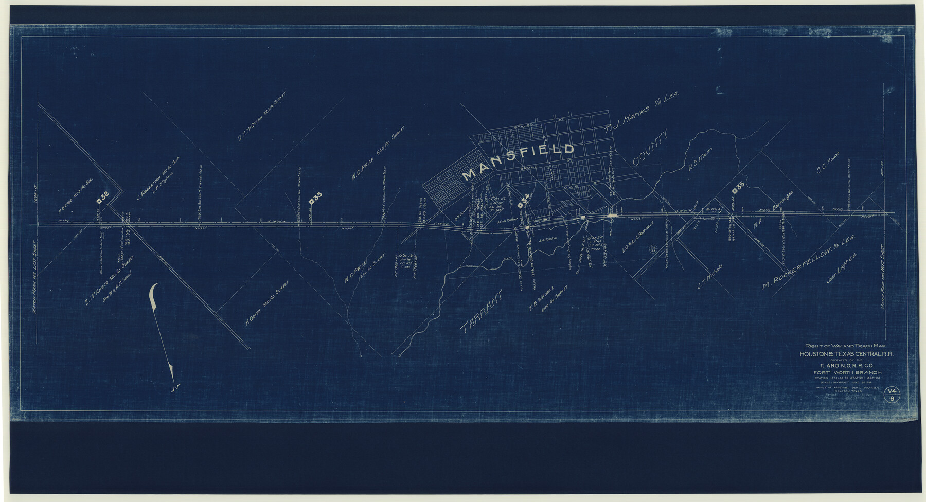
Right of Way and Track Map Houston & Texas Central R.R. operated by the T. and N. O. R.R. Co., Fort Worth Branch
Station 1674+00 to Station 1885+00
Z-2-164
-
Map/Doc
64541
-
Collection
General Map Collection
-
Object Dates
1930/12/31 (Revision Date)
1918/6/13 (Creation Date)
-
Counties
Tarrant
-
Subjects
Railroads
-
Height x Width
30.9 x 57.1 inches
78.5 x 145.0 cm
-
Medium
blueprint/diazo
-
Scale
1" = 400 feet
-
Comments
Operated by Texas and New Orleans Railroad.
See counter nos. 64539 and 64540 and 64542 through 64544 and 64779 through 64784 for other sheets of the map. -
Features
H&TC
Mansfield
Part of: General Map Collection
Bell County Working Sketch 14

Print $20.00
- Digital $50.00
Bell County Working Sketch 14
1966
Size 38.7 x 30.8 inches
Map/Doc 67354

Parker County Working Sketch Graphic Index

Print $20.00
- Digital $50.00
Parker County Working Sketch Graphic Index
1942
Map/Doc 76661
Plan of the town of Austin

Print $20.00
- Digital $50.00
Plan of the town of Austin
Size 18.4 x 13.0 inches
Map/Doc 94117
Galveston County Rolled Sketch 31

Print $20.00
- Digital $50.00
Galveston County Rolled Sketch 31
1979
Size 28.4 x 39.8 inches
Map/Doc 5965
Kerr County Working Sketch 27

Print $20.00
- Digital $50.00
Kerr County Working Sketch 27
1970
Size 25.4 x 20.8 inches
Map/Doc 70058
Aransas County Working Sketch 5

Print $20.00
- Digital $50.00
Aransas County Working Sketch 5
1928
Size 19.7 x 23.2 inches
Map/Doc 67172
Val Verde County Rolled Sketch 69

Print $40.00
- Digital $50.00
Val Verde County Rolled Sketch 69
1942
Size 72.5 x 20.0 inches
Map/Doc 9805
Matagorda County Sketch File 38

Print $20.00
- Digital $50.00
Matagorda County Sketch File 38
1904
Size 24.4 x 33.0 inches
Map/Doc 12046
Rusk County Rolled Sketch 14

Print $20.00
- Digital $50.00
Rusk County Rolled Sketch 14
1997
Size 27.8 x 37.8 inches
Map/Doc 7549
Flight Mission No. BRA-7M, Frame 39, Jefferson County

Print $20.00
- Digital $50.00
Flight Mission No. BRA-7M, Frame 39, Jefferson County
1953
Size 18.7 x 22.5 inches
Map/Doc 85490
Parker County Sketch File 31

Print $6.00
- Digital $50.00
Parker County Sketch File 31
1877
Size 9.9 x 9.8 inches
Map/Doc 33572
You may also like
Comanche County Working Sketch 27

Print $40.00
- Digital $50.00
Comanche County Working Sketch 27
1983
Size 50.2 x 43.5 inches
Map/Doc 68161
Duval County Working Sketch 51

Print $20.00
- Digital $50.00
Duval County Working Sketch 51
1986
Size 27.3 x 35.3 inches
Map/Doc 68775
[Blocks A, B and C]
![89867, [Blocks A, B and C], Twichell Survey Records](https://historictexasmaps.com/wmedia_w700/maps/89867-1.tif.jpg)
Print $40.00
- Digital $50.00
[Blocks A, B and C]
Size 36.0 x 59.0 inches
Map/Doc 89867
General Highway Map, Reagan County, Texas

Print $20.00
General Highway Map, Reagan County, Texas
1940
Size 25.0 x 18.2 inches
Map/Doc 79225

Cliffside Situated on Section 21, Block 9, Potter County, Texas

Print $2.00
- Digital $50.00
Cliffside Situated on Section 21, Block 9, Potter County, Texas
Size 6.1 x 11.5 inches
Map/Doc 92100
Lubbock County Boundary File 7

Print $40.00
- Digital $50.00
Lubbock County Boundary File 7
Size 20.6 x 5.8 inches
Map/Doc 56523

Flight Mission No. DQN-2K, Frame 48, Calhoun County

Print $20.00
- Digital $50.00
Flight Mission No. DQN-2K, Frame 48, Calhoun County
1953
Size 17.1 x 22.2 inches
Map/Doc 84253

Jeff Davis County Texas

Print $20.00
- Digital $50.00
Jeff Davis County Texas
Size 15.9 x 21.3 inches
Map/Doc 4573
Bastrop County Rolled Sketch 1A

Print $20.00
- Digital $50.00
Bastrop County Rolled Sketch 1A
Size 37.0 x 24.5 inches
Map/Doc 5122