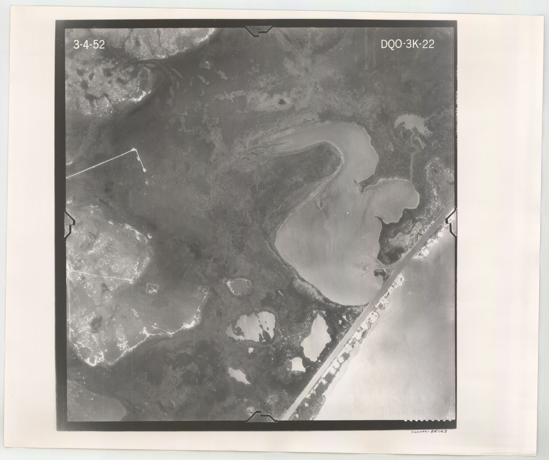
Flight Mission No. DQO-3K, Frame 22, Galveston County
DQO-3K-22
-
Map/Doc
85063
-
Collection
General Map Collection
-
Object Dates
1952/3/4 (Creation Date)
-
People and Organizations
U. S. Department of Agriculture (Publisher)
-
Counties
Galveston
-
Subjects
Aerial Photograph
-
Height x Width
18.8 x 22.5 inches
47.8 x 57.2 cm
-
Comments
Flown by Aero Exploration Company of Tulsa, Oklahoma.
Part of: General Map Collection
Flight Mission No. DQO-3K, Frame 23, Galveston County

Print $20.00
- Digital $50.00
Flight Mission No. DQO-3K, Frame 23, Galveston County
1952
Size 18.8 x 22.5 inches
Map/Doc 85064
La Salle County Working Sketch 16

Print $20.00
- Digital $50.00
La Salle County Working Sketch 16
1936
Size 26.5 x 16.2 inches
Map/Doc 70317
Houston County Rolled Sketch 3

Print $57.00
- Digital $50.00
Houston County Rolled Sketch 3
1935
Size 23.5 x 23.4 inches
Map/Doc 6226
Lampasas County Working Sketch 24

Print $20.00
- Digital $50.00
Lampasas County Working Sketch 24
Size 14.3 x 13.3 inches
Map/Doc 61796
Galveston County Sketch File 49

Print $2.00
- Digital $50.00
Galveston County Sketch File 49
Size 5.5 x 8.6 inches
Map/Doc 23480
Kaufman County State Real Property Sketch 1

Print $92.00
- Digital $50.00
Kaufman County State Real Property Sketch 1
2006
Size 24.6 x 35.4 inches
Map/Doc 88624
Brooks County Rolled Sketch 27

Print $20.00
- Digital $50.00
Brooks County Rolled Sketch 27
1945
Size 44.5 x 42.9 inches
Map/Doc 8540
Chambers County Rolled Sketch 23

Print $40.00
- Digital $50.00
Chambers County Rolled Sketch 23
1940
Size 36.5 x 49.2 inches
Map/Doc 8591
Schleicher County Sketch File 28

Print $40.00
- Digital $50.00
Schleicher County Sketch File 28
1939
Size 17.4 x 14.2 inches
Map/Doc 36526
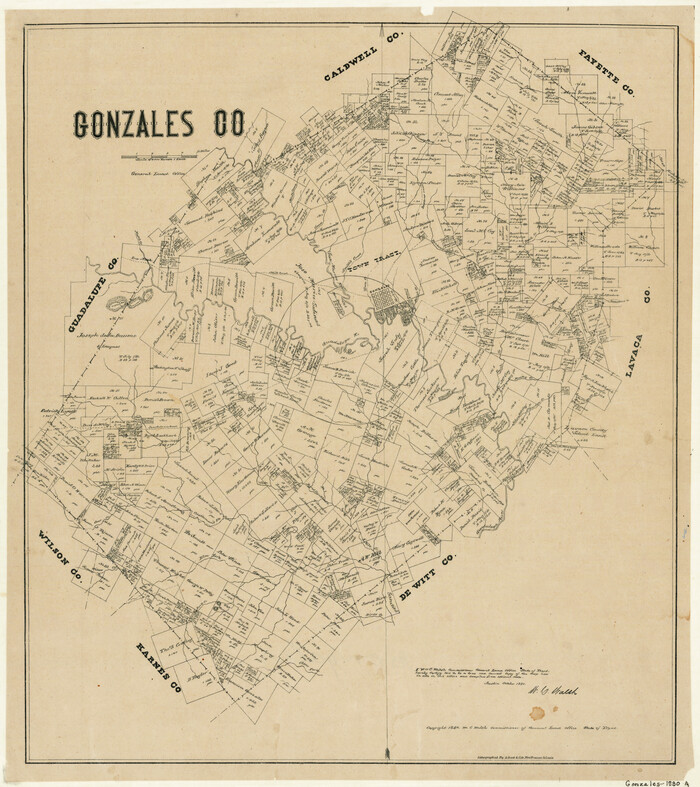
Gonzales County
Print $20.00
- Digital $50.00
Gonzales County
1880
Size 25.3 x 22.6 inches
Map/Doc 3594
Chambers County Rolled Sketch 22

Print $20.00
- Digital $50.00
Chambers County Rolled Sketch 22
1940
Size 24.9 x 38.9 inches
Map/Doc 5427
Archer County Rolled Sketch 9

Print $20.00
- Digital $50.00
Archer County Rolled Sketch 9
1891
Size 35.9 x 30.6 inches
Map/Doc 5104
You may also like
Comanche County Working Sketch 15

Print $20.00
- Digital $50.00
Comanche County Working Sketch 15
1964
Size 20.3 x 25.5 inches
Map/Doc 68149
The Rand-McNally New Commercial Atlas Map of Texas

Print $20.00
The Rand-McNally New Commercial Atlas Map of Texas
1914
Size 28.6 x 42.4 inches
Map/Doc 78225
Medina County Working Sketch 23

Print $20.00
- Digital $50.00
Medina County Working Sketch 23
Size 43.8 x 43.1 inches
Map/Doc 70938

Victoria County Sketch File 4

Print $7.00
- Digital $50.00
Victoria County Sketch File 4
1876
Size 10.1 x 8.2 inches
Map/Doc 39517
Castro County Sketch File 6

Print $20.00
- Digital $50.00
Castro County Sketch File 6
Size 20.8 x 15.6 inches
Map/Doc 11059
Scurry County Working Sketch 6

Print $20.00
- Digital $50.00
Scurry County Working Sketch 6
1950
Size 38.7 x 37.3 inches
Map/Doc 63835
Rachford's Complete Map of the City of Beaumont

Print $20.00
- Digital $50.00
Rachford's Complete Map of the City of Beaumont
1897
Size 33.4 x 23.6 inches
Map/Doc 97355
Maps of Gulf Intracoastal Waterway, Texas - Sabine River to the Rio Grande and connecting waterways including ship channels

Print $20.00
- Digital $50.00
Maps of Gulf Intracoastal Waterway, Texas - Sabine River to the Rio Grande and connecting waterways including ship channels
1966
Size 14.6 x 22.2 inches
Map/Doc 61939
Garza County Sketch File 23

Print $6.00
- Digital $50.00
Garza County Sketch File 23
1907
Size 11.3 x 8.7 inches
Map/Doc 24080
Leon County Rolled Sketch 26A

Print $20.00
- Digital $50.00
Leon County Rolled Sketch 26A
1988
Size 21.5 x 34.4 inches
Map/Doc 6611
Comanche County Sketch File 19 3/4

Print $40.00
- Digital $50.00
Comanche County Sketch File 19 3/4
Size 15.7 x 12.9 inches
Map/Doc 19101