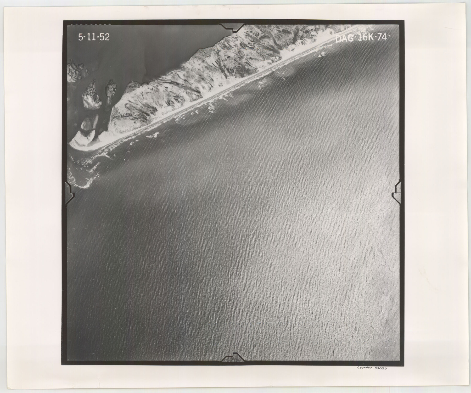
Flight Mission No. DAG-16K, Frame 74, Matagorda County
DAG-16K-74
-
Map/Doc
86320
-
Collection
General Map Collection
-
Object Dates
1952/5/11 (Creation Date)
-
People and Organizations
U. S. Department of Agriculture (Publisher)
-
Counties
Matagorda
-
Subjects
Aerial Photograph
-
Height x Width
18.6 x 22.3 inches
47.2 x 56.6 cm
-
Comments
Flown by Aero Exploration Company of Tulsa, Oklahoma.
Part of: General Map Collection
Culberson County Sketch File 42

Print $14.00
- Digital $50.00
Culberson County Sketch File 42
1966
Size 14.2 x 8.7 inches
Map/Doc 20322
Pecos County Working Sketch 117

Print $40.00
- Digital $50.00
Pecos County Working Sketch 117
1973
Size 57.7 x 36.8 inches
Map/Doc 71590
Flight Mission No. CLL-4N, Frame 33, Willacy County

Print $20.00
- Digital $50.00
Flight Mission No. CLL-4N, Frame 33, Willacy County
1954
Size 18.3 x 22.0 inches
Map/Doc 87106
Wichita County Sketch File 16a

Print $4.00
- Digital $50.00
Wichita County Sketch File 16a
Size 14.2 x 8.7 inches
Map/Doc 40097
Refugio County Rolled Sketch 7

Print $20.00
- Digital $50.00
Refugio County Rolled Sketch 7
1946
Size 28.4 x 34.5 inches
Map/Doc 7508
San Antonio and Aransas Pass Ry. from Survey Station 4852+100 to Survey Station 5280+00

Print $4.00
- Digital $50.00
San Antonio and Aransas Pass Ry. from Survey Station 4852+100 to Survey Station 5280+00
Size 11.8 x 18.6 inches
Map/Doc 62570
Hutchinson County Working Sketch 32

Print $20.00
- Digital $50.00
Hutchinson County Working Sketch 32
1978
Size 27.8 x 23.6 inches
Map/Doc 66392
Cooke County Sketch File 15

Print $4.00
- Digital $50.00
Cooke County Sketch File 15
1860
Size 12.5 x 8.1 inches
Map/Doc 19250
[Triangulation Net of Part of Texas. Travis County to Red River]
![3101, [Triangulation Net of Part of Texas. Travis County to Red River], General Map Collection](https://historictexasmaps.com/wmedia_w700/maps/3101.tif.jpg)
Print $20.00
- Digital $50.00
[Triangulation Net of Part of Texas. Travis County to Red River]
1928
Size 28.2 x 33.9 inches
Map/Doc 3101
Panola County Working Sketch 15

Print $40.00
- Digital $50.00
Panola County Working Sketch 15
1945
Map/Doc 71424
Val Verde County Sketch File Z4

Print $8.00
- Digital $50.00
Val Verde County Sketch File Z4
1885
Size 14.3 x 8.9 inches
Map/Doc 39134
You may also like

Flight Mission No. DAG-17K, Frame 135, Matagorda County

Print $20.00
- Digital $50.00
Flight Mission No. DAG-17K, Frame 135, Matagorda County
1952
Size 17.4 x 16.1 inches
Map/Doc 86352
Crockett County Working Sketch 95

Print $20.00
- Digital $50.00
Crockett County Working Sketch 95
1979
Size 26.6 x 47.2 inches
Map/Doc 68428
Flight Mission No. BRA-8M, Frame 81, Jefferson County

Print $20.00
- Digital $50.00
Flight Mission No. BRA-8M, Frame 81, Jefferson County
1953
Size 16.0 x 15.8 inches
Map/Doc 85601

Duval County Sketch File 68

Print $20.00
- Digital $50.00
Duval County Sketch File 68
Size 23.9 x 19.6 inches
Map/Doc 11407
[Boundary Survey of County]
![89735, [Boundary Survey of County], Twichell Survey Records](https://historictexasmaps.com/wmedia_w700/maps/89735-1.tif.jpg)
Print $40.00
- Digital $50.00
[Boundary Survey of County]
Size 64.9 x 37.0 inches
Map/Doc 89735
Upton County Rolled Sketch 47

Print $20.00
- Digital $50.00
Upton County Rolled Sketch 47
1937
Size 22.6 x 35.3 inches
Map/Doc 8083
Val Verde County Sketch File Z19

Print $26.00
- Digital $50.00
Val Verde County Sketch File Z19
1912
Size 23.1 x 21.1 inches
Map/Doc 12559
Presidio County Working Sketch 97

Print $20.00
- Digital $50.00
Presidio County Working Sketch 97
1978
Size 28.2 x 28.0 inches
Map/Doc 71774
1882 Map of the Texas & Pacific R-Y Reserve

Print $40.00
- Digital $50.00
1882 Map of the Texas & Pacific R-Y Reserve
1888
Size 95.6 x 42.5 inches
Map/Doc 2299
Irion County Working Sketch 6

Print $20.00
- Digital $50.00
Irion County Working Sketch 6
1935
Size 16.6 x 30.8 inches
Map/Doc 66415