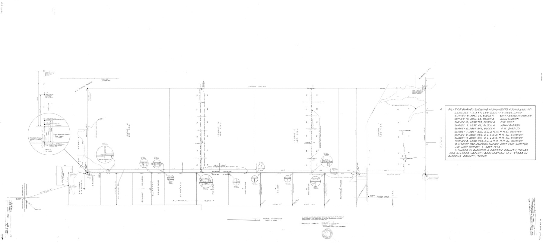
Dickens County Rolled Sketch 14
Mineral Application 71084- Dickens County, Texas
- 
                          Map/Doc8792
- 
                            CollectionGeneral Map Collection
- 
                            CountiesDickens
- 
                            Height x Width36.5 x 80.7 inches92.7 x 205.0 cm
Part of: General Map Collection
            Galveston County Sketch File 53


                                            Print $119.00                    
                                             -                         Digital $50.00                                    
                Galveston County Sketch File 53
1964
Size 14.3 x 8.8 inches
                                Map/Doc 23527
            
            Webb County Rolled Sketch 53


                                            Print $40.00                    
                                             -                         Digital $50.00                                    
                Webb County Rolled Sketch 53
1944
Size 83.5 x 28.6 inches
                                Map/Doc 49483
            
            Taylor County Rolled Sketch 28


                                            Print $20.00                    
                                             -                         Digital $50.00                                    
                Taylor County Rolled Sketch 28
Size 34.4 x 23.9 inches
                                Map/Doc 7921
            
            Flight Mission No. CRE-2R, Frame 160, Jackson County


                                            Print $20.00                    
                                             -                         Digital $50.00                                    
                Flight Mission No. CRE-2R, Frame 160, Jackson County
1956
Size 18.5 x 22.3 inches
                                Map/Doc 85371
            
            [Surveys in the Bexar District along the Pedernales River]
            
                                    ![177, [Surveys in the Bexar District along the Pedernales River], General Map Collection](https://historictexasmaps.com/wmedia_w700/maps/177.tif.jpg) 


    ![177, [Surveys in the Bexar District along the Pedernales River], General Map Collection](https://historictexasmaps.com/wmedia_w700/maps/177.tif.jpg) 
                                
            
                                            Print $20.00                    
                                             -                         Digital $50.00                                    
                [Surveys in the Bexar District along the Pedernales River]
1845
Size 18.7 x 11.0 inches
                                Map/Doc 177
            
            Map of Eagle Lake


                                            Print $20.00                    
                                             -                         Digital $50.00                                    
                Map of Eagle Lake
1938
Size 13.0 x 17.0 inches
                                Map/Doc 2208
            
            Goliad County Working Sketch 20


                                            Print $20.00                    
                                             -                         Digital $50.00                                    
                Goliad County Working Sketch 20
1955
Size 31.4 x 22.8 inches
                                Map/Doc 63210
            
            Val Verde County Sketch File XXX8


                                            Print $6.00                    
                                             -                         Digital $50.00                                    
                Val Verde County Sketch File XXX8
Size 9.0 x 16.4 inches
                                Map/Doc 39106
            
            Fort Bend County Sketch File 30


                                            Print $18.00                    
                                             -                         Digital $50.00                                    
                Fort Bend County Sketch File 30
1920
Size 12.1 x 6.5 inches
                                Map/Doc 22988
            
            Texas Gulf Coast Map from the Sabine River to the Rio Grande as subdivided for mineral development


                                            Print $40.00                    
                                             -                         Digital $50.00                                    
                Texas Gulf Coast Map from the Sabine River to the Rio Grande as subdivided for mineral development
1948
Size 60.9 x 36.7 inches
                                Map/Doc 2909
            
            Starr County Working Sketch 19


                                            Print $20.00                    
                                             -                         Digital $50.00                                    
                Starr County Working Sketch 19
1982
Size 27.3 x 33.9 inches
                                Map/Doc 63935
            
            Bandera County Sketch File 4


                                            Print $4.00                    
                                             -                         Digital $50.00                                    
                Bandera County Sketch File 4
Size 9.3 x 8.3 inches
                                Map/Doc 14001
            You may also like
            Carta Particular de las Costas Setentrionales del Seno Mexicano que comprehende las de la Florída Ocidental las Márgenes de la Luisiana y toda la rivera que sigue por la Bahía de S. Bernardo y el Rio Bravo del Norte hasta la Laguna Madre


            Carta Particular de las Costas Setentrionales del Seno Mexicano que comprehende las de la Florída Ocidental las Márgenes de la Luisiana y toda la rivera que sigue por la Bahía de S. Bernardo y el Rio Bravo del Norte hasta la Laguna Madre
1807
Size 27.3 x 40.3 inches
                                Map/Doc 94565
            
            Pecos County Sketch File 49c


                                            Print $10.00                    
                                             -                         Digital $50.00                                    
                Pecos County Sketch File 49c
Size 5.9 x 8.7 inches
                                Map/Doc 33768
            
            Bowie County Working Sketch 8


                                            Print $20.00                    
                                             -                         Digital $50.00                                    
                Bowie County Working Sketch 8
1953
Size 25.9 x 24.0 inches
                                Map/Doc 67412
            
            Coast Chart No. 210 - Aransas Pass and Corpus Christi Bay with the coast to latitude 27° 12', Texas


                                            Print $20.00                    
                                             -                         Digital $50.00                                    
                Coast Chart No. 210 - Aransas Pass and Corpus Christi Bay with the coast to latitude 27° 12', Texas
1907
Size 44.2 x 36.5 inches
                                Map/Doc 73449
            
            Leon County Working Sketch 57


                                            Print $20.00                    
                                             -                         Digital $50.00                                    
                Leon County Working Sketch 57
1994
Size 34.3 x 30.7 inches
                                Map/Doc 70457
            
            United States - Gulf Coast - Galveston to Rio Grande


                                            Print $20.00                    
                                             -                         Digital $50.00                                    
                United States - Gulf Coast - Galveston to Rio Grande
1940
Size 27.0 x 18.2 inches
                                Map/Doc 72755
            
            Presidio County Sketch File 116A


                                            Print $63.00                    
                                             -                         Digital $50.00                                    
                Presidio County Sketch File 116A
Size 17.0 x 11.0 inches
                                Map/Doc 34885
            
            Erath County Sketch File 16a


                                            Print $4.00                    
                                             -                         Digital $50.00                                    
                Erath County Sketch File 16a
1874
Size 12.7 x 8.1 inches
                                Map/Doc 22296
            
            Kinney County Boundary File 1b


                                            Print $8.00                    
                                             -                         Digital $50.00                                    
                Kinney County Boundary File 1b
Size 14.3 x 8.7 inches
                                Map/Doc 64955
            
            Map of Jones County


                                            Print $20.00                    
                                             -                         Digital $50.00                                    
                Map of Jones County
1898
Size 41.9 x 39.8 inches
                                Map/Doc 4996
            
            Austin County Working Sketch 6


                                            Print $20.00                    
                                             -                         Digital $50.00                                    
                Austin County Working Sketch 6
1985
Size 30.3 x 28.5 inches
                                Map/Doc 67247
            
            Flight Mission No. DQO-12K, Frame 42, Galveston County


                                            Print $20.00                    
                                             -                         Digital $50.00                                    
                Flight Mission No. DQO-12K, Frame 42, Galveston County
1952
Size 18.6 x 22.3 inches
                                Map/Doc 85232
            