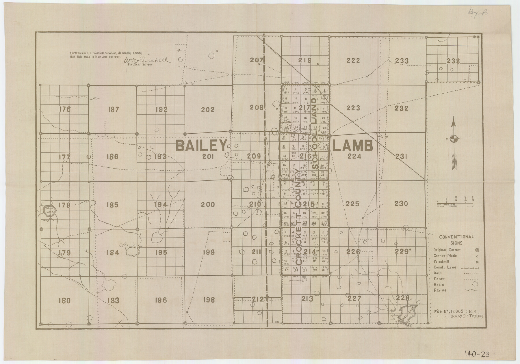
C.C. Slaughter's Running Water Ranch situated in Hale and Lamb Counties
140-23
-
Map/Doc
91050
-
Collection
Twichell Survey Records
-
People and Organizations
W.D. Twichell (Surveyor/Engineer)
-
Counties
Lamb Bailey
-
Height x Width
26.5 x 18.8 inches
67.3 x 47.8 cm
Part of: Twichell Survey Records
[T. T. RR. Co. Block 8 and vicinity]
![90795, [T. T. RR. Co. Block 8 and vicinity], Twichell Survey Records](https://historictexasmaps.com/wmedia_w700/maps/90795-1.tif.jpg)
Print $20.00
- Digital $50.00
[T. T. RR. Co. Block 8 and vicinity]
Size 20.3 x 15.2 inches
Map/Doc 90795

[Block 1PD and Vicinity]
![91536, [Block 1PD and Vicinity], Twichell Survey Records](https://historictexasmaps.com/wmedia_w700/maps/91536-1.tif.jpg)
Print $3.00
- Digital $50.00
[Block 1PD and Vicinity]
Size 11.4 x 9.7 inches
Map/Doc 91536
[G. & M. Block 5]
![91802, [G. & M. Block 5], Twichell Survey Records](https://historictexasmaps.com/wmedia_w700/maps/91802-1.tif.jpg)
Print $20.00
- Digital $50.00
[G. & M. Block 5]
Size 20.3 x 12.5 inches
Map/Doc 91802
Sylvan Sander's Map of Lubbock, Hockley, and Cochran Counties, Texas

Print $20.00
- Digital $50.00
Sylvan Sander's Map of Lubbock, Hockley, and Cochran Counties, Texas
1925
Size 43.6 x 21.8 inches
Map/Doc 92611
[H. & T. C. Blocks 47 1/2 and 50]
![90643, [H. & T. C. Blocks 47 1/2 and 50], Twichell Survey Records](https://historictexasmaps.com/wmedia_w700/maps/90643-1.tif.jpg)
Print $20.00
- Digital $50.00
[H. & T. C. Blocks 47 1/2 and 50]
Size 35.5 x 16.8 inches
Map/Doc 90643
Sketch of the Giles Connell Ranch in Ector and Crane Counties

Print $20.00
- Digital $50.00
Sketch of the Giles Connell Ranch in Ector and Crane Counties
1918
Size 12.8 x 19.6 inches
Map/Doc 90303
[Parts of Blocks Z, L, M-21, M-15, and 46]
![91831, [Parts of Blocks Z, L, M-21, M-15, and 46], Twichell Survey Records](https://historictexasmaps.com/wmedia_w700/maps/91831-1.tif.jpg)
Print $20.00
- Digital $50.00
[Parts of Blocks Z, L, M-21, M-15, and 46]
Size 21.2 x 16.7 inches
Map/Doc 91831
Map showing connections and corners made on ground in south part of Yoakum County and north part of Gaines County, Texas

Print $20.00
- Digital $50.00
Map showing connections and corners made on ground in south part of Yoakum County and north part of Gaines County, Texas
1938
Size 43.7 x 36.5 inches
Map/Doc 93255
Swisher Co. Texas

Print $20.00
- Digital $50.00
Swisher Co. Texas
1936
Size 36.8 x 38.0 inches
Map/Doc 89876
[Capitol Leagues in Lamb County]
![91013, [Capitol Leagues in Lamb County], Twichell Survey Records](https://historictexasmaps.com/wmedia_w700/maps/91013-1.tif.jpg)
Print $2.00
- Digital $50.00
[Capitol Leagues in Lamb County]
1912
Size 13.1 x 8.8 inches
Map/Doc 91013
[Blocks DD, C33, C32, C31, C36, C37, C38, C39, C41, C40, T]
![92935, [Blocks DD, C33, C32, C31, C36, C37, C38, C39, C41, C40, T], Twichell Survey Records](https://historictexasmaps.com/wmedia_w700/maps/92935-1.tif.jpg)
Print $20.00
- Digital $50.00
[Blocks DD, C33, C32, C31, C36, C37, C38, C39, C41, C40, T]
Size 44.0 x 24.8 inches
Map/Doc 92935
You may also like
Bell County Sketch File 29a

Print $4.00
- Digital $50.00
Bell County Sketch File 29a
1875
Size 12.4 x 8.6 inches
Map/Doc 14441
Dimmit County Working Sketch 32

Print $20.00
- Digital $50.00
Dimmit County Working Sketch 32
1959
Size 29.2 x 23.3 inches
Map/Doc 68693
Willie Winn Tract

Print $2.00
- Digital $50.00
Willie Winn Tract
1903
Size 5.9 x 7.6 inches
Map/Doc 92285
Coryell County Boundary File 3a

Print $50.00
- Digital $50.00
Coryell County Boundary File 3a
Size 13.2 x 8.1 inches
Map/Doc 51914
Flight Mission No. DAG-21K, Frame 116, Matagorda County

Print $20.00
- Digital $50.00
Flight Mission No. DAG-21K, Frame 116, Matagorda County
1952
Size 18.6 x 22.3 inches
Map/Doc 86439
Right of Way and Track Map Houston & Texas Central R.R. operated by the T. and N. O. R.R. Co., Fort Worth Branch

Print $40.00
- Digital $50.00
Right of Way and Track Map Houston & Texas Central R.R. operated by the T. and N. O. R.R. Co., Fort Worth Branch
1918
Size 30.7 x 56.4 inches
Map/Doc 64542
Flight Mission No. DQO-1K, Frame 116, Galveston County

Print $20.00
- Digital $50.00
Flight Mission No. DQO-1K, Frame 116, Galveston County
1952
Size 18.8 x 22.6 inches
Map/Doc 84994
Harris County Working Sketch 118

Print $20.00
- Digital $50.00
Harris County Working Sketch 118
1984
Size 24.1 x 34.8 inches
Map/Doc 66010
Zavala County

Print $20.00
- Digital $50.00
Zavala County
1915
Size 38.6 x 46.6 inches
Map/Doc 16940

Coke County Working Sketch 15

Print $20.00
- Digital $50.00
Coke County Working Sketch 15
1948
Size 25.7 x 21.7 inches
Map/Doc 68052
Flight Mission No. DQO-12K, Frame 41, Galveston County

Print $20.00
- Digital $50.00
Flight Mission No. DQO-12K, Frame 41, Galveston County
1952
Size 18.6 x 22.4 inches
Map/Doc 85231