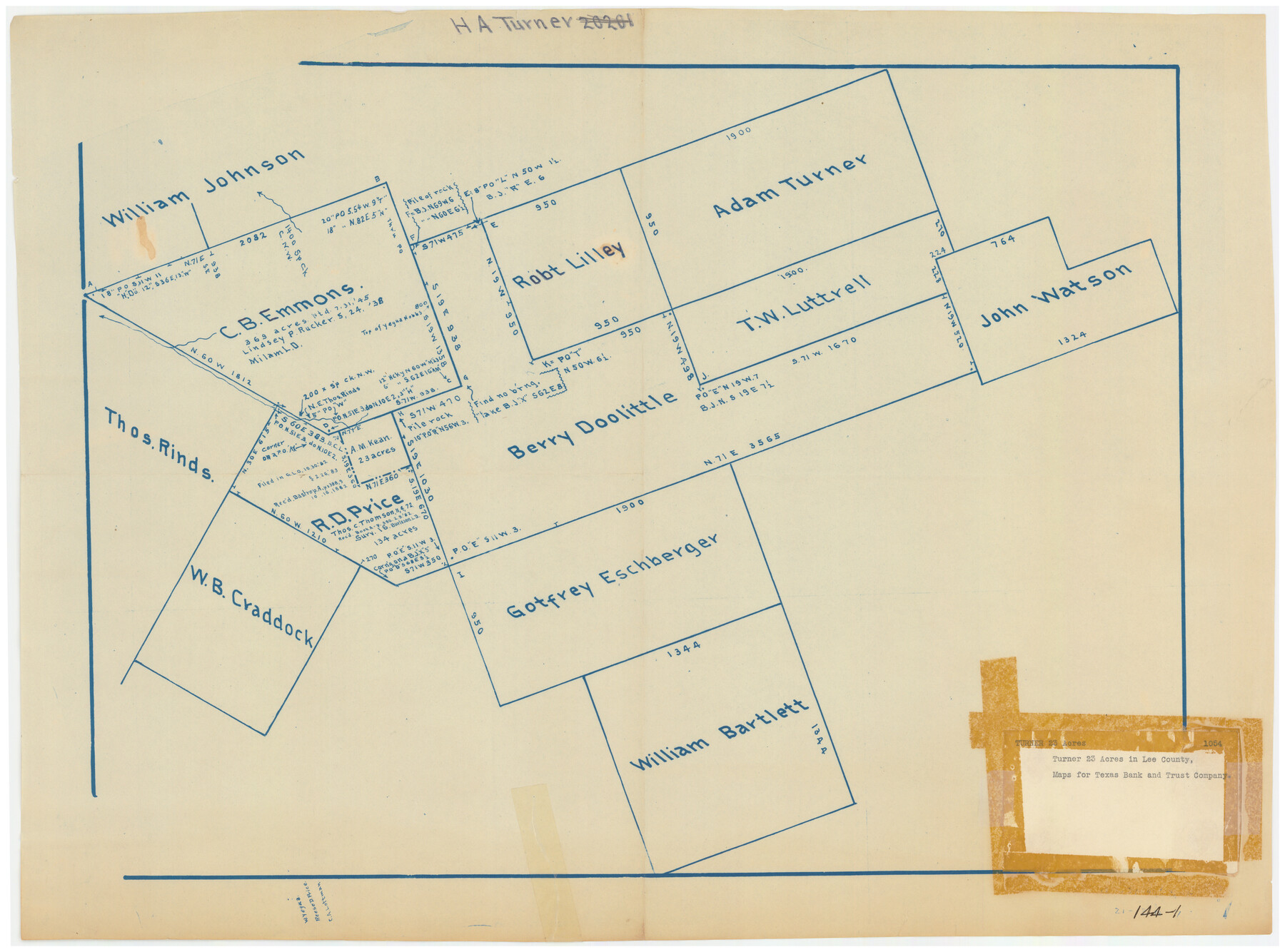
Turner 23 Acres in Lee County
144-1
-
Map/Doc
91081
-
Collection
Twichell Survey Records
-
Counties
Lee
-
Height x Width
27.0 x 20.2 inches
68.6 x 51.3 cm
Part of: Twichell Survey Records
[H. & T. C. Block 46]
![92980, [H. & T. C. Block 46], Twichell Survey Records](https://historictexasmaps.com/wmedia_w700/maps/92980-1.tif.jpg)
Print $20.00
- Digital $50.00
[H. & T. C. Block 46]
Size 28.5 x 17.9 inches
Map/Doc 92980
Map of Public Land on Mustang Island

Print $20.00
- Digital $50.00
Map of Public Land on Mustang Island
1907
Size 17.7 x 22.3 inches
Map/Doc 91492
[Blocks 44 and 6T]
![91410, [Blocks 44 and 6T], Twichell Survey Records](https://historictexasmaps.com/wmedia_w700/maps/91410-1.tif.jpg)
Print $20.00
- Digital $50.00
[Blocks 44 and 6T]
Size 29.3 x 17.4 inches
Map/Doc 91410
City of Andrews

Print $20.00
- Digital $50.00
City of Andrews
1951
Size 25.1 x 24.2 inches
Map/Doc 92454
[Plat map showing mostly Overton Addition]
![92825, [Plat map showing mostly Overton Addition], Twichell Survey Records](https://historictexasmaps.com/wmedia_w700/maps/92825-1.tif.jpg)
Print $20.00
- Digital $50.00
[Plat map showing mostly Overton Addition]
Size 31.7 x 31.4 inches
Map/Doc 92825

[Townships 1, 2, 3, Blocks, 62, 61, 60, 59, 58, 57, 56]
![92884, [Townships 1, 2, 3, Blocks, 62, 61, 60, 59, 58, 57, 56], Twichell Survey Records](https://historictexasmaps.com/wmedia_w700/maps/92884-1.tif.jpg)
Print $20.00
- Digital $50.00
[Townships 1, 2, 3, Blocks, 62, 61, 60, 59, 58, 57, 56]
1885
Size 19.1 x 10.3 inches
Map/Doc 92884
[South Part of Terrell County, West Part of Val Verde County]
![91960, [South Part of Terrell County, West Part of Val Verde County], Twichell Survey Records](https://historictexasmaps.com/wmedia_w700/maps/91960-1.tif.jpg)
Print $20.00
- Digital $50.00
[South Part of Terrell County, West Part of Val Verde County]
Size 38.6 x 18.5 inches
Map/Doc 91960
Section A, Tech Memorial Park, Inc.

Print $20.00
- Digital $50.00
Section A, Tech Memorial Park, Inc.
Size 21.6 x 15.6 inches
Map/Doc 92785
[Blocks M-23, M-17, M-18, H, G, and vicinity]
![91141, [Blocks M-23, M-17, M-18, H, G, and vicinity], Twichell Survey Records](https://historictexasmaps.com/wmedia_w700/maps/91141-1.tif.jpg)
Print $20.00
- Digital $50.00
[Blocks M-23, M-17, M-18, H, G, and vicinity]
1882
Size 12.9 x 12.4 inches
Map/Doc 91141
Map in the Southern Portion of Pecos County Texas

Print $40.00
- Digital $50.00
Map in the Southern Portion of Pecos County Texas
1882
Size 64.6 x 21.6 inches
Map/Doc 89692
Block 11, Capitol Syndicate Subdivision of Capitol Land Reservation Leagues

Print $20.00
- Digital $50.00
Block 11, Capitol Syndicate Subdivision of Capitol Land Reservation Leagues
Size 25.0 x 26.2 inches
Map/Doc 90737
You may also like
Jim Wells County Sketch File 1

Print $20.00
- Digital $50.00
Jim Wells County Sketch File 1
1931
Size 22.9 x 22.1 inches
Map/Doc 11889
La Salle County Sketch File 39

Print $6.00
- Digital $50.00
La Salle County Sketch File 39
1912
Size 16.4 x 11.4 inches
Map/Doc 29592
Coke County Rolled Sketch 10

Print $20.00
- Digital $50.00
Coke County Rolled Sketch 10
1949
Size 25.3 x 15.0 inches
Map/Doc 5509
Runnels County Working Sketch 29

Print $20.00
- Digital $50.00
Runnels County Working Sketch 29
1959
Size 27.1 x 30.0 inches
Map/Doc 63625
[West half of Deaf Smith County Map]
![90510, [West half of Deaf Smith County Map], Twichell Survey Records](https://historictexasmaps.com/wmedia_w700/maps/90510-1.tif.jpg)
Print $2.00
- Digital $50.00
[West half of Deaf Smith County Map]
Size 7.6 x 12.5 inches
Map/Doc 90510
Map of Surveys Made for the T&PRR in Borden, Dawson, Howard & Martin Counties, Blocks 32, 33, 34, 35 & 36, Reserve West of the Colorado

Print $20.00
- Digital $50.00
Map of Surveys Made for the T&PRR in Borden, Dawson, Howard & Martin Counties, Blocks 32, 33, 34, 35 & 36, Reserve West of the Colorado
1876
Size 42.0 x 38.2 inches
Map/Doc 2231
Burnet County Sketch File 10

Print $4.00
- Digital $50.00
Burnet County Sketch File 10
1848
Size 12.8 x 8.4 inches
Map/Doc 16690
Stephens County

Print $20.00
- Digital $50.00
Stephens County
1940
Size 40.3 x 38.9 inches
Map/Doc 77426
Right of Way and Track Map, Houston & Texas Central R.R. operated by the T. and N. O. R.R., Fort Worth Branch

Print $40.00
- Digital $50.00
Right of Way and Track Map, Houston & Texas Central R.R. operated by the T. and N. O. R.R., Fort Worth Branch
1918
Size 31.7 x 56.8 inches
Map/Doc 64784
Navasota River, Long Bridge Crossing Sheet

Print $20.00
- Digital $50.00
Navasota River, Long Bridge Crossing Sheet
1934
Size 43.1 x 36.6 inches
Map/Doc 65073
Atascosa County Working Sketch 27

Print $20.00
- Digital $50.00
Atascosa County Working Sketch 27
1963
Size 16.8 x 18.6 inches
Map/Doc 67223
[Sketch in vicinity of Wm. McCutcheon, S. H. Reid and John McGinley]
![92129, [Sketch in vicinity of Wm. McCutcheon, S. H. Reid and John McGinley], Twichell Survey Records](https://historictexasmaps.com/wmedia_w700/maps/92129-1.tif.jpg)
Print $20.00
- Digital $50.00
[Sketch in vicinity of Wm. McCutcheon, S. H. Reid and John McGinley]
1923
Size 20.0 x 12.4 inches
Map/Doc 92129