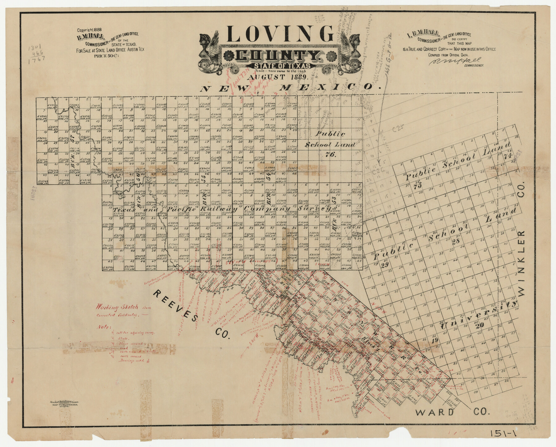
Loving County
151-1
-
Map/Doc
91319
-
Collection
Twichell Survey Records
-
Object Dates
8/1889 (Creation Date)
-
Counties
Loving
-
Subjects
County
-
Height x Width
24.7 x 20.1 inches
62.7 x 51.1 cm
Part of: Twichell Survey Records
[Part of H. & G. N. Blocks 2 and D-13]
![90490, [Part of H. & G. N. Blocks 2 and D-13], Twichell Survey Records](https://historictexasmaps.com/wmedia_w700/maps/90490-1.tif.jpg)
Print $20.00
- Digital $50.00
[Part of H. & G. N. Blocks 2 and D-13]
1907
Size 14.1 x 17.7 inches
Map/Doc 90490
Richland Hills Addition to Muleshoe, Bailey County, Texas

Print $20.00
- Digital $50.00
Richland Hills Addition to Muleshoe, Bailey County, Texas
1957
Size 22.7 x 31.7 inches
Map/Doc 92461
[W. H. Freeman, W. A. Eads, W. M. McKnight, Surveys 18, 19, and 28]
![91084, [W. H. Freeman, W. A. Eads, W. M. McKnight, Surveys 18, 19, and 28], Twichell Survey Records](https://historictexasmaps.com/wmedia_w700/maps/91084-1.tif.jpg)
Print $20.00
- Digital $50.00
[W. H. Freeman, W. A. Eads, W. M. McKnight, Surveys 18, 19, and 28]
Size 27.3 x 18.6 inches
Map/Doc 91084
Temple Morrow Irrigated Farm South Half of Section 1, Block D6

Print $3.00
- Digital $50.00
Temple Morrow Irrigated Farm South Half of Section 1, Block D6
Size 9.5 x 12.8 inches
Map/Doc 92311
[Map showing J. H. Gibson Blocks D and DD]
![92000, [Map showing J. H. Gibson Blocks D and DD], Twichell Survey Records](https://historictexasmaps.com/wmedia_w700/maps/92000-1.tif.jpg)
Print $20.00
- Digital $50.00
[Map showing J. H. Gibson Blocks D and DD]
Size 26.1 x 18.8 inches
Map/Doc 92000
[Sketch showing B. S. & F. survey 9, sections 162, 163, 178, 179 in town of Bush]
![91728, [Sketch showing B. S. & F. survey 9, sections 162, 163, 178, 179 in town of Bush], Twichell Survey Records](https://historictexasmaps.com/wmedia_w700/maps/91728-1.tif.jpg)
Print $20.00
- Digital $50.00
[Sketch showing B. S. & F. survey 9, sections 162, 163, 178, 179 in town of Bush]
Size 12.0 x 16.1 inches
Map/Doc 91728
[Worksheets related to the Wilson Strickland survey and vicinity]
![91350, [Worksheets related to the Wilson Strickland survey and vicinity], Twichell Survey Records](https://historictexasmaps.com/wmedia_w700/maps/91350-1.tif.jpg)
Print $20.00
- Digital $50.00
[Worksheets related to the Wilson Strickland survey and vicinity]
Size 29.6 x 43.6 inches
Map/Doc 91350
Working Sketch Showing Scrap Lands in Hale County

Print $20.00
- Digital $50.00
Working Sketch Showing Scrap Lands in Hale County
1915
Size 22.7 x 11.1 inches
Map/Doc 90742
Sketch in Parmer County

Print $20.00
- Digital $50.00
Sketch in Parmer County
1901
Size 15.1 x 23.8 inches
Map/Doc 91644
[H. & T. C. Block 46]
![92980, [H. & T. C. Block 46], Twichell Survey Records](https://historictexasmaps.com/wmedia_w700/maps/92980-1.tif.jpg)
Print $20.00
- Digital $50.00
[H. & T. C. Block 46]
Size 28.5 x 17.9 inches
Map/Doc 92980
[B. S. & F. Block 1 and A. B. & M. Block 2]
![91815, [B. S. & F. Block 1 and A. B. & M. Block 2], Twichell Survey Records](https://historictexasmaps.com/wmedia_w700/maps/91815-1.tif.jpg)
Print $20.00
- Digital $50.00
[B. S. & F. Block 1 and A. B. & M. Block 2]
Size 14.0 x 21.5 inches
Map/Doc 91815
Plat in Pecos County, Texas

Print $20.00
- Digital $50.00
Plat in Pecos County, Texas
Size 33.2 x 23.1 inches
Map/Doc 91601
You may also like
Goliad County Sketch File 27

Print $20.00
- Digital $50.00
Goliad County Sketch File 27
Size 19.0 x 24.4 inches
Map/Doc 11568
Newton County Rolled Sketch 18

Print $40.00
- Digital $50.00
Newton County Rolled Sketch 18
1955
Size 41.6 x 59.2 inches
Map/Doc 9580
Flight Mission No. CRC-5R, Frame 24, Chambers County

Print $20.00
- Digital $50.00
Flight Mission No. CRC-5R, Frame 24, Chambers County
1956
Size 18.7 x 22.4 inches
Map/Doc 84946
Texas Boundary Line

Print $20.00
- Digital $50.00
Texas Boundary Line
Size 21.4 x 11.8 inches
Map/Doc 92076
Ellwood Farms Subdivision Number 2 of the Spade Ranch Lamb and Hale Counties, Texas

Print $20.00
- Digital $50.00
Ellwood Farms Subdivision Number 2 of the Spade Ranch Lamb and Hale Counties, Texas
Size 22.2 x 31.4 inches
Map/Doc 92258
General Highway Map, Cameron County, Texas

Print $20.00
General Highway Map, Cameron County, Texas
1940
Size 18.4 x 25.3 inches
Map/Doc 79038
Flight Mission No. BRA-7M, Frame 197, Jefferson County

Print $20.00
- Digital $50.00
Flight Mission No. BRA-7M, Frame 197, Jefferson County
1953
Size 18.6 x 22.4 inches
Map/Doc 85565
Matagorda County Working Sketch 21

Print $20.00
- Digital $50.00
Matagorda County Working Sketch 21
1966
Size 35.5 x 41.2 inches
Map/Doc 70879
Deaf Smith County

Print $40.00
- Digital $50.00
Deaf Smith County
1926
Size 38.5 x 50.3 inches
Map/Doc 95477
Runnels County Sketch File 36

Print $20.00
Runnels County Sketch File 36
1889
Size 20.9 x 19.6 inches
Map/Doc 12267
Wilson County Sketch File 5

Print $4.00
- Digital $50.00
Wilson County Sketch File 5
1859
Size 6.6 x 8.2 inches
Map/Doc 40408
Flight Mission No. CRK-7P, Frame 28, Refugio County

Print $20.00
- Digital $50.00
Flight Mission No. CRK-7P, Frame 28, Refugio County
1956
Size 18.4 x 22.1 inches
Map/Doc 86948