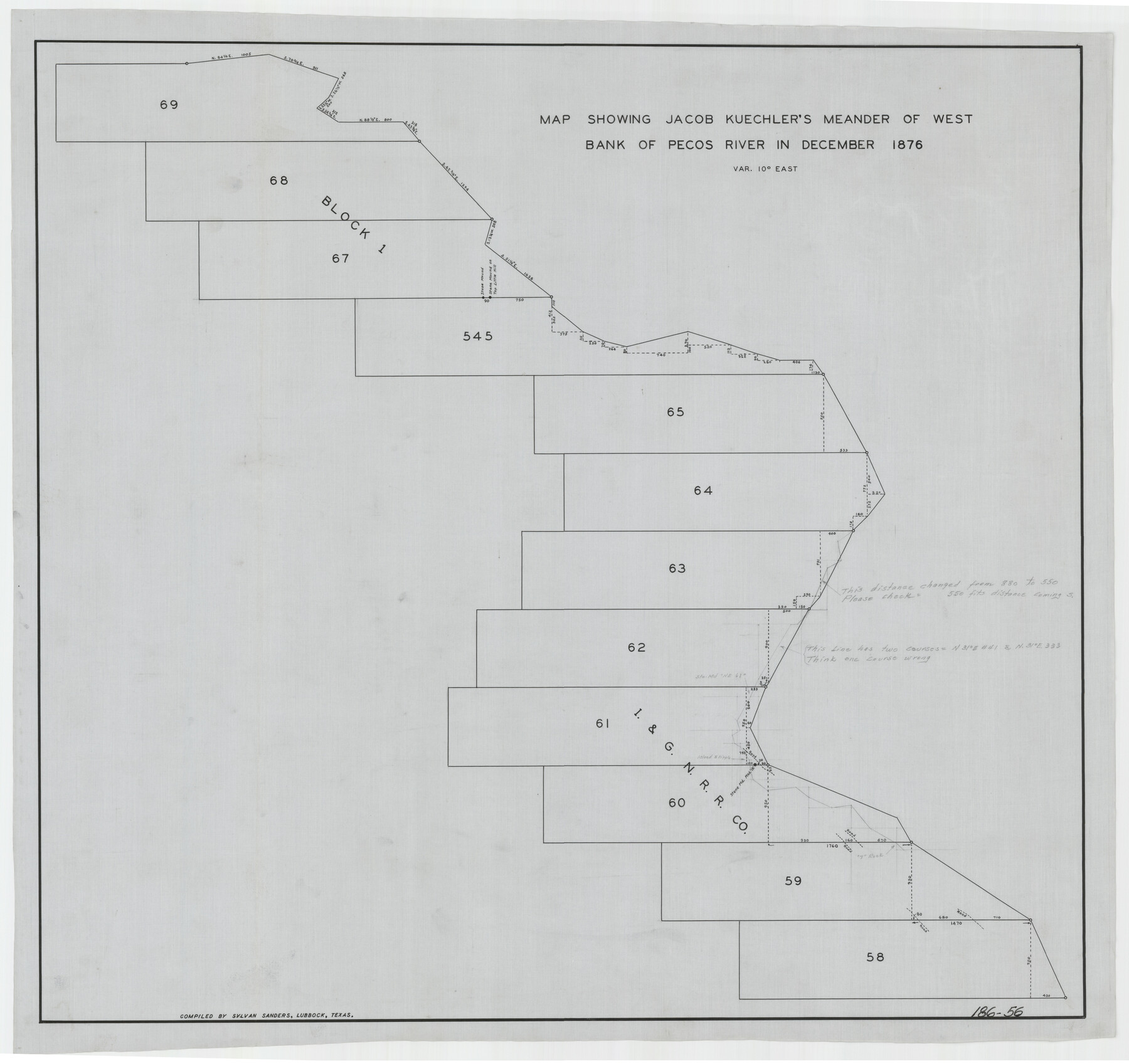
Map Showing Jacob Kuechler's Meander of West Bank of Pecos River in December 1876
186-56
-
Map/Doc
91669
-
Collection
Twichell Survey Records
-
People and Organizations
Sylvan Sanders (Compiler)
-
Counties
Pecos
-
Height x Width
18.6 x 17.4 inches
47.2 x 44.2 cm
Part of: Twichell Survey Records
[Sketch showing the southwest part of the Glidden and Sanborn Addition]
![91746, [Sketch showing the southwest part of the Glidden and Sanborn Addition], Twichell Survey Records](https://historictexasmaps.com/wmedia_w700/maps/91746-1.tif.jpg)
Print $20.00
- Digital $50.00
[Sketch showing the southwest part of the Glidden and Sanborn Addition]
Size 20.0 x 29.3 inches
Map/Doc 91746
[Sketch showing Blocks M-20 and M-22]
![91722, [Sketch showing Blocks M-20 and M-22], Twichell Survey Records](https://historictexasmaps.com/wmedia_w700/maps/91722-1.tif.jpg)
Print $20.00
- Digital $50.00
[Sketch showing Blocks M-20 and M-22]
Size 15.0 x 19.5 inches
Map/Doc 91722
Highland Place an Addition to City of Lubbock

Print $20.00
- Digital $50.00
Highland Place an Addition to City of Lubbock
Size 25.9 x 22.1 inches
Map/Doc 92844
[Blocks M13, S1, C3, JK3, and JK]
![90700, [Blocks M13, S1, C3, JK3, and JK], Twichell Survey Records](https://historictexasmaps.com/wmedia_w700/maps/90700-1.tif.jpg)
Print $20.00
- Digital $50.00
[Blocks M13, S1, C3, JK3, and JK]
Size 26.9 x 15.4 inches
Map/Doc 90700
Capitol Syndicate Subdivision of Capitol Land Reservation Leagues Number 153, 154, 155, 156, 157, 158, 167, 168, 169, 170, 171, and 172 and Parts of Leagues 143, 144, 145, 146, 152, 159, 166, and 173

Print $20.00
- Digital $50.00
Capitol Syndicate Subdivision of Capitol Land Reservation Leagues Number 153, 154, 155, 156, 157, 158, 167, 168, 169, 170, 171, and 172 and Parts of Leagues 143, 144, 145, 146, 152, 159, 166, and 173
1908
Size 22.8 x 34.6 inches
Map/Doc 90735
[Section 70, Block 8, Dawson and Lynn Counties, Texas]
![92562, [Section 70, Block 8, Dawson and Lynn Counties, Texas], Twichell Survey Records](https://historictexasmaps.com/wmedia_w700/maps/92562-1.tif.jpg)
Print $20.00
- Digital $50.00
[Section 70, Block 8, Dawson and Lynn Counties, Texas]
Size 23.9 x 19.6 inches
Map/Doc 92562
Boyd-Gordon Addition to Idalou, a Subdivision of a Part Tracts 27, 28, 29 and 30 of the Ross Addition to Idalou

Print $3.00
- Digital $50.00
Boyd-Gordon Addition to Idalou, a Subdivision of a Part Tracts 27, 28, 29 and 30 of the Ross Addition to Idalou
1953
Size 11.8 x 17.8 inches
Map/Doc 92873
Working Sketch in Stephens County

Print $20.00
- Digital $50.00
Working Sketch in Stephens County
1919
Size 15.4 x 18.6 inches
Map/Doc 91912
[Sections 58-70, I. & G. N. Block 1, Runnels County School Land and part of Block 194]
![91632, [Sections 58-70, I. & G. N. Block 1, Runnels County School Land and part of Block 194], Twichell Survey Records](https://historictexasmaps.com/wmedia_w700/maps/91632-1.tif.jpg)
Print $20.00
- Digital $50.00
[Sections 58-70, I. & G. N. Block 1, Runnels County School Land and part of Block 194]
Size 23.9 x 20.9 inches
Map/Doc 91632
S. F. Singleton's Lands Sold to H. B. Herd, Located in Southwest Part of Lynn County

Print $20.00
- Digital $50.00
S. F. Singleton's Lands Sold to H. B. Herd, Located in Southwest Part of Lynn County
1908
Size 12.1 x 23.1 inches
Map/Doc 91339
[Leagues 27, 28, 69, 70, 71, 72, and 73]
![91096, [Leagues 27, 28, 69, 70, 71, 72, and 73], Twichell Survey Records](https://historictexasmaps.com/wmedia_w700/maps/91096-1.tif.jpg)
Print $20.00
- Digital $50.00
[Leagues 27, 28, 69, 70, 71, 72, and 73]
Size 24.0 x 15.7 inches
Map/Doc 91096
Castro County

Print $20.00
- Digital $50.00
Castro County
1884
Size 12.6 x 16.1 inches
Map/Doc 90396
You may also like
Callahan County, Texas

Print $20.00
- Digital $50.00
Callahan County, Texas
1880
Size 24.1 x 18.4 inches
Map/Doc 681
Gaines County Rolled Sketch 14C

Print $40.00
- Digital $50.00
Gaines County Rolled Sketch 14C
1940
Size 85.0 x 23.2 inches
Map/Doc 9034
Aransas County Rolled Sketch 19C

Print $20.00
- Digital $50.00
Aransas County Rolled Sketch 19C
Size 40.9 x 30.6 inches
Map/Doc 5063
Anderson County

Print $20.00
- Digital $50.00
Anderson County
1871
Size 18.3 x 20.8 inches
Map/Doc 776
Flight Mission No. DCL-7C, Frame 72, Kenedy County

Print $20.00
- Digital $50.00
Flight Mission No. DCL-7C, Frame 72, Kenedy County
1943
Size 15.4 x 15.1 inches
Map/Doc 86058
[Sketch for Mineral Application 36486 and 38244 - Liberty County]
![65621, [Sketch for Mineral Application 36486 and 38244 - Liberty County], General Map Collection](https://historictexasmaps.com/wmedia_w700/maps/65621.tif.jpg)
Print $20.00
- Digital $50.00
[Sketch for Mineral Application 36486 and 38244 - Liberty County]
1976
Size 24.0 x 43.9 inches
Map/Doc 65621
Schleicher County Working Sketch 12

Print $20.00
- Digital $50.00
Schleicher County Working Sketch 12
1925
Size 23.7 x 22.2 inches
Map/Doc 63814
Brazos Island Harbor, Texas - Dredging Entrance Channel Plan

Print $20.00
- Digital $50.00
Brazos Island Harbor, Texas - Dredging Entrance Channel Plan
1990
Size 14.6 x 20.0 inches
Map/Doc 83337
Gillespie County

Print $40.00
- Digital $50.00
Gillespie County
1945
Size 41.0 x 50.0 inches
Map/Doc 95507
[Leagues 464-467 and vicinity]
![91649, [Leagues 464-467 and vicinity], Twichell Survey Records](https://historictexasmaps.com/wmedia_w700/maps/91649-1.tif.jpg)
Print $2.00
- Digital $50.00
[Leagues 464-467 and vicinity]
Size 10.6 x 8.1 inches
Map/Doc 91649
Flight Mission No. DIX-5P, Frame 146, Aransas County

Print $20.00
- Digital $50.00
Flight Mission No. DIX-5P, Frame 146, Aransas County
1956
Size 17.7 x 17.9 inches
Map/Doc 83808
Webb County Sketch File 6-1

Print $6.00
- Digital $50.00
Webb County Sketch File 6-1
1877
Size 9.8 x 12.7 inches
Map/Doc 39737