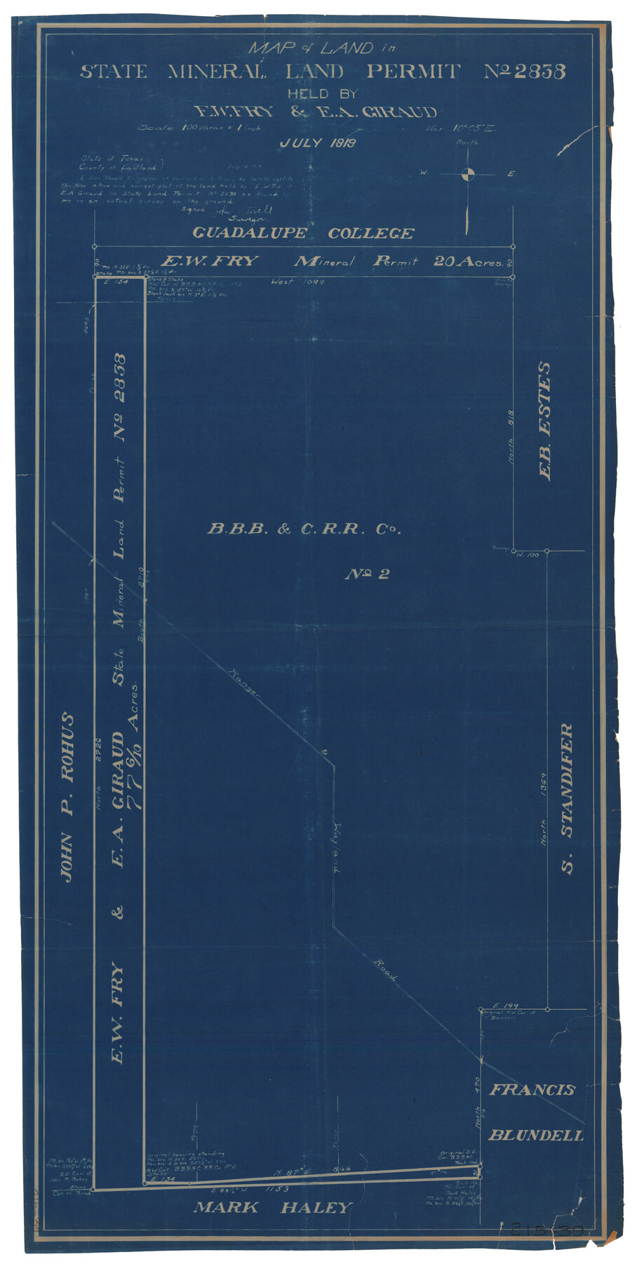
Map of Land in State Mineral Land Permit No. 2838 held by E. W. Fry and E. A. Giraud
215-39
-
Map/Doc
91837
-
Collection
Twichell Survey Records
-
Object Dates
7/1919 (Creation Date)
-
People and Organizations
John Stovell (Surveyor/Engineer)
-
Counties
Stephens
-
Height x Width
18.4 x 37.3 inches
46.7 x 94.7 cm
Part of: Twichell Survey Records
[Capitol Leagues 217, 218, 219 and 220]
![91460, [Capitol Leagues 217, 218, 219 and 220], Twichell Survey Records](https://historictexasmaps.com/wmedia_w700/maps/91460-1.tif.jpg)
Print $20.00
- Digital $50.00
[Capitol Leagues 217, 218, 219 and 220]
Size 23.2 x 10.3 inches
Map/Doc 91460
Sheet 4 copied from Peck Book 6 [Strip Map showing T. & P. connecting lines]
![93170, Sheet 4 copied from Peck Book 6 [Strip Map showing T. & P. connecting lines], Twichell Survey Records](https://historictexasmaps.com/wmedia_w700/maps/93170-1.tif.jpg)
Print $40.00
- Digital $50.00
Sheet 4 copied from Peck Book 6 [Strip Map showing T. & P. connecting lines]
1909
Size 7.0 x 54.8 inches
Map/Doc 93170
Map of the Capitol Land Reservation

Print $40.00
- Digital $50.00
Map of the Capitol Land Reservation
Size 26.3 x 49.5 inches
Map/Doc 92042
[H. & T. C. Blocks 1 and 2]
![91049, [H. & T. C. Blocks 1 and 2], Twichell Survey Records](https://historictexasmaps.com/wmedia_w700/maps/91049-1.tif.jpg)
Print $3.00
- Digital $50.00
[H. & T. C. Blocks 1 and 2]
Size 13.3 x 11.7 inches
Map/Doc 91049
Evans Subdivision Number 2

Print $20.00
- Digital $50.00
Evans Subdivision Number 2
Size 23.9 x 19.4 inches
Map/Doc 92497
[Sketch of surveys around W.T. Brewer]
![89926, [Sketch of surveys around W.T. Brewer], Twichell Survey Records](https://historictexasmaps.com/wmedia_w700/maps/89926-1.tif.jpg)
Print $40.00
- Digital $50.00
[Sketch of surveys around W.T. Brewer]
Size 37.0 x 48.7 inches
Map/Doc 89926
[Sketch showing G. & M. Block 5]
![91704, [Sketch showing G. & M. Block 5], Twichell Survey Records](https://historictexasmaps.com/wmedia_w700/maps/91704-1.tif.jpg)
Print $2.00
- Digital $50.00
[Sketch showing G. & M. Block 5]
Size 7.5 x 5.8 inches
Map/Doc 91704
Blocks JD, B, and A3

Print $3.00
- Digital $50.00
Blocks JD, B, and A3
Size 11.5 x 13.8 inches
Map/Doc 90743
W. C. Baze Subdivision a part of Tracts 25, 26, 27 and 28, Ross Addition to City of Idalou, Lubbock Co.

Print $20.00
- Digital $50.00
W. C. Baze Subdivision a part of Tracts 25, 26, 27 and 28, Ross Addition to City of Idalou, Lubbock Co.
1955
Size 9.2 x 18.9 inches
Map/Doc 92761
Showing Position of Original and Re-Survey Corners in Lynn, Terry, Yoakum, Gaines and Dawson Counties, Texas

Print $40.00
- Digital $50.00
Showing Position of Original and Re-Survey Corners in Lynn, Terry, Yoakum, Gaines and Dawson Counties, Texas
1946
Size 57.3 x 22.1 inches
Map/Doc 93044
[Gunter & Munson and Surrounding Surveys]
![91238, [Gunter & Munson and Surrounding Surveys], Twichell Survey Records](https://historictexasmaps.com/wmedia_w700/maps/91238-1.tif.jpg)
Print $20.00
- Digital $50.00
[Gunter & Munson and Surrounding Surveys]
Size 16.3 x 21.4 inches
Map/Doc 91238
[Blocks S1, O6, O, A1, A2, A3, A4, JK, JK2, JK4, and JD]
![90658, [Blocks S1, O6, O, A1, A2, A3, A4, JK, JK2, JK4, and JD], Twichell Survey Records](https://historictexasmaps.com/wmedia_w700/maps/90658-1.tif.jpg)
Print $20.00
- Digital $50.00
[Blocks S1, O6, O, A1, A2, A3, A4, JK, JK2, JK4, and JD]
Size 20.3 x 21.7 inches
Map/Doc 90658
You may also like
Ellwood Place, Installment No. 3

Print $20.00
- Digital $50.00
Ellwood Place, Installment No. 3
Size 17.8 x 24.9 inches
Map/Doc 92791
Limestone County Working Sketch 25

Print $20.00
- Digital $50.00
Limestone County Working Sketch 25
1981
Size 26.1 x 21.1 inches
Map/Doc 70575
Milam County Sketch File 8

Print $20.00
- Digital $50.00
Milam County Sketch File 8
1856
Size 16.8 x 33.7 inches
Map/Doc 12091
Half-circle Protractor with Arm and Vernier

Half-circle Protractor with Arm and Vernier
Size 0.8 x 15.0 inches
Map/Doc 97309
University Land in Cooke County

Print $20.00
- Digital $50.00
University Land in Cooke County
1906
Size 23.6 x 30.0 inches
Map/Doc 2425
Trinity River, Levee Improvement Districts Widths of Floodways

Print $6.00
- Digital $50.00
Trinity River, Levee Improvement Districts Widths of Floodways
1920
Size 33.9 x 23.0 inches
Map/Doc 65249
Hutchinson County Rolled Sketch 29

Print $20.00
- Digital $50.00
Hutchinson County Rolled Sketch 29
1925
Size 19.3 x 13.9 inches
Map/Doc 6291
Flight Mission No. BRE-1P, Frame 47, Nueces County

Print $20.00
- Digital $50.00
Flight Mission No. BRE-1P, Frame 47, Nueces County
1956
Size 18.4 x 22.3 inches
Map/Doc 86636
Live Oak County Working Sketch 26

Print $20.00
- Digital $50.00
Live Oak County Working Sketch 26
1980
Size 13.9 x 16.9 inches
Map/Doc 70611
Cameron County Sketch File 8b

Print $145.00
- Digital $50.00
Cameron County Sketch File 8b
Size 14.0 x 8.5 inches
Map/Doc 17137
Map of the District of San Patricio and Nueces

Print $40.00
- Digital $50.00
Map of the District of San Patricio and Nueces
1847
Size 52.6 x 44.2 inches
Map/Doc 1956
[T. & P. Block 35, Townships 1N - 5N]
![93138, [T. & P. Block 35, Townships 1N - 5N], Twichell Survey Records](https://historictexasmaps.com/wmedia_w700/maps/93138-1.tif.jpg)
Print $40.00
- Digital $50.00
[T. & P. Block 35, Townships 1N - 5N]
Size 23.8 x 87.2 inches
Map/Doc 93138