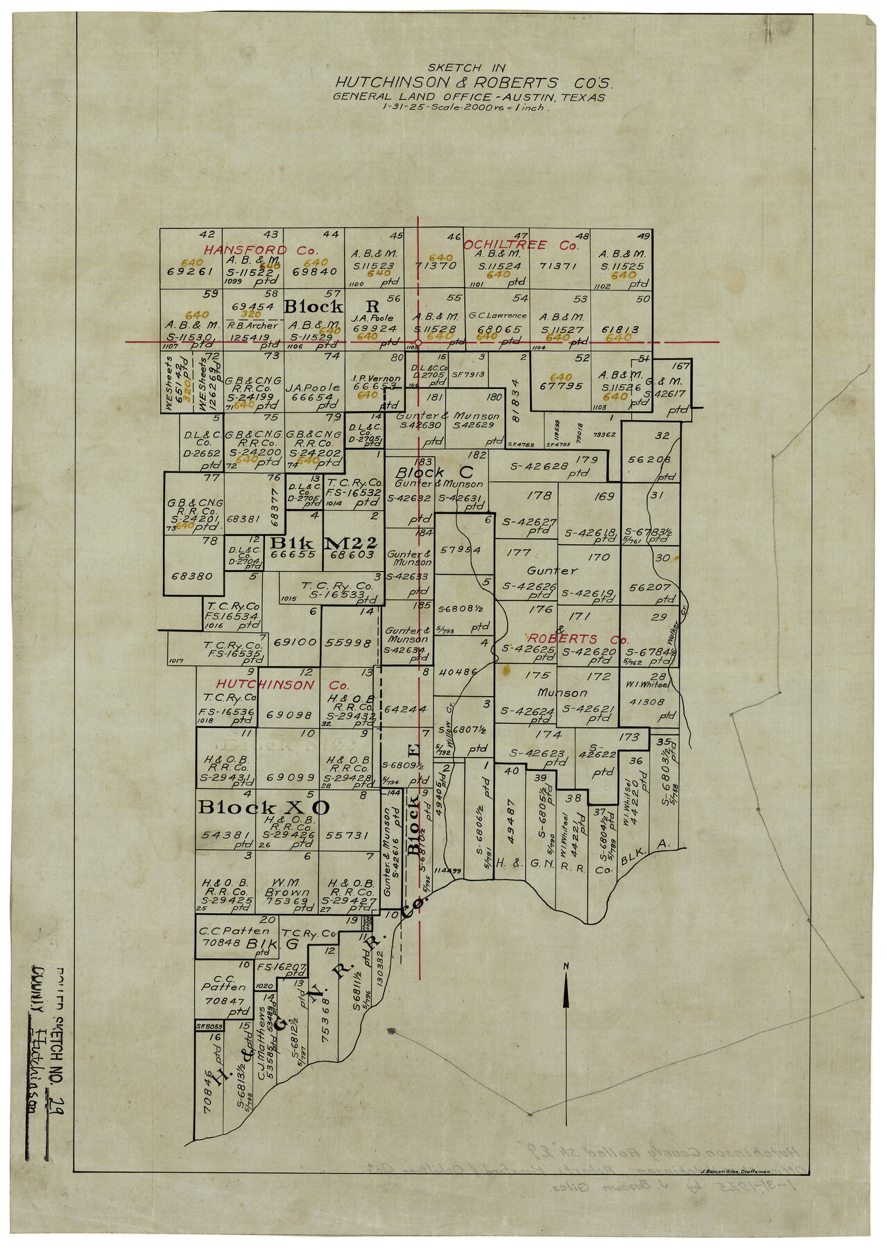
Hutchinson County Rolled Sketch 29
Sketch in Hutchinson & Roberts Cos.
-
Map/Doc
6291
-
Collection
General Map Collection
-
Object Dates
1/31/1925 (Creation Date)
-
Counties
Hutchinson Roberts Hansford Ochiltree
-
Subjects
Surveying Rolled Sketch
-
Height x Width
19.3 x 13.9 inches
49.0 x 35.3 cm
-
Medium
linen, manuscript
-
Scale
1" = 2000 varas
Part of: General Map Collection
Kimble County Working Sketch 82

Print $20.00
- Digital $50.00
Kimble County Working Sketch 82
1971
Size 43.3 x 27.7 inches
Map/Doc 70150
San Jacinto County Sketch File 13

Print $4.00
San Jacinto County Sketch File 13
Size 5.3 x 8.1 inches
Map/Doc 35723
Crockett County Working Sketch 8

Print $20.00
- Digital $50.00
Crockett County Working Sketch 8
1903
Size 15.2 x 30.3 inches
Map/Doc 68341
Flight Mission No. DQN-2K, Frame 93, Calhoun County

Print $20.00
- Digital $50.00
Flight Mission No. DQN-2K, Frame 93, Calhoun County
1953
Size 16.5 x 16.2 inches
Map/Doc 84283
Blanco County Boundary File 10

Print $26.00
- Digital $50.00
Blanco County Boundary File 10
Size 8.9 x 7.6 inches
Map/Doc 50576
Crockett County Sketch File 63

Print $4.00
- Digital $50.00
Crockett County Sketch File 63
1927
Size 11.0 x 8.8 inches
Map/Doc 19851
Stephens County

Print $20.00
- Digital $50.00
Stephens County
1940
Size 42.9 x 41.0 inches
Map/Doc 63045
Map showing state tracts in E. part of Corpus Christi Bay and surveys on Harbor Island & Corpus Christi channel

Print $40.00
- Digital $50.00
Map showing state tracts in E. part of Corpus Christi Bay and surveys on Harbor Island & Corpus Christi channel
1978
Size 53.4 x 37.7 inches
Map/Doc 2501
Marion County Rolled Sketch S

Print $20.00
- Digital $50.00
Marion County Rolled Sketch S
1937
Size 18.8 x 18.1 inches
Map/Doc 6663
La Salle County Working Sketch 26

Print $20.00
- Digital $50.00
La Salle County Working Sketch 26
1949
Size 28.2 x 16.3 inches
Map/Doc 70327
Cooke County Sketch File 40

Print $20.00
- Digital $50.00
Cooke County Sketch File 40
Size 36.3 x 34.0 inches
Map/Doc 10341
Rusk County Sketch File Y

Print $6.00
Rusk County Sketch File Y
1845
Size 16.7 x 11.0 inches
Map/Doc 35537
You may also like
Rockwall County

Print $20.00
- Digital $50.00
Rockwall County
1941
Size 28.5 x 23.9 inches
Map/Doc 63006
Medina County Boundary File 2

Print $11.00
- Digital $50.00
Medina County Boundary File 2
Size 13.0 x 8.1 inches
Map/Doc 57026
Guadalupe County Working Sketch Graphic Index

Print $20.00
- Digital $50.00
Guadalupe County Working Sketch Graphic Index
1977
Size 35.5 x 46.5 inches
Map/Doc 76561
Brewster County Rolled Sketch 135

Print $20.00
- Digital $50.00
Brewster County Rolled Sketch 135
Size 43.1 x 41.5 inches
Map/Doc 8525
Midland County Rolled Sketch 3

Print $40.00
- Digital $50.00
Midland County Rolled Sketch 3
Size 71.7 x 24.4 inches
Map/Doc 9514
Map of Padre Island Showing Location of Zoning Districts

Print $20.00
- Digital $50.00
Map of Padre Island Showing Location of Zoning Districts
1971
Size 26.4 x 18.8 inches
Map/Doc 4813
Bee County Working Sketch 7

Print $20.00
- Digital $50.00
Bee County Working Sketch 7
1939
Size 17.8 x 20.6 inches
Map/Doc 67257
Texas Intracoastal Waterway - Stover Point to Port Brownsville including Brazos Santiago

Print $20.00
- Digital $50.00
Texas Intracoastal Waterway - Stover Point to Port Brownsville including Brazos Santiago
1965
Size 27.5 x 38.9 inches
Map/Doc 73521
T and P as Surveyed January 1876, Blocks 35-36

Print $40.00
- Digital $50.00
T and P as Surveyed January 1876, Blocks 35-36
1876
Size 29.0 x 95.2 inches
Map/Doc 93184
Flight Mission No. CLL-1N, Frame 160, Willacy County

Print $20.00
- Digital $50.00
Flight Mission No. CLL-1N, Frame 160, Willacy County
1954
Size 18.3 x 22.0 inches
Map/Doc 87051
Sketch for Mineral Application 33721 - 33725 Incl (Attorney General) - Map of Padre Island - Cameron, Willacy, Kleberg, Nueces and Kenedy Counties.

Print $20.00
- Digital $50.00
Sketch for Mineral Application 33721 - 33725 Incl (Attorney General) - Map of Padre Island - Cameron, Willacy, Kleberg, Nueces and Kenedy Counties.
Size 43.3 x 23.1 inches
Map/Doc 65663
Colonial Texas. 1822 to 1834.

Print $20.00
- Digital $50.00
Colonial Texas. 1822 to 1834.
1897
Size 12.8 x 16.3 inches
Map/Doc 93410