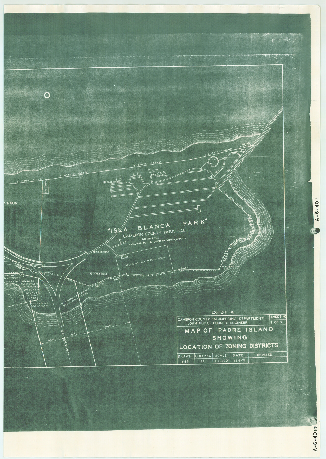
Map of Padre Island Showing Location of Zoning Districts
A-6-40-f
- 
                          Map/Doc4813
- 
                            CollectionGeneral Map Collection
- 
                            Object Dates1971/12/1 (Creation Date)
- 
                            People and OrganizationsJohn Huth (Surveyor/Engineer)FBN (Draftsman)
- 
                            CountiesCameron
- 
                            SubjectsCity
- 
                            Height x Width26.4 x 18.8 inches67.1 x 47.8 cm
- 
                            Mediumblueprint/diazo
- 
                            Scale1" = 400 feet
- 
                            CommentsOne of six pieces. Shows south part of Padre Island from Andy Bowie Park to Isla Blanca Park. See map numbers 4808 through 4812 for other pieces.
- 
                            Features[Padre Island][Gulf of Mexico]North JettiesIsla Blanca ParkCameron County Park No. 1
Part of: General Map Collection
            Harris County Sketch File 88


                                            Print $171.00                    
                                             -                         Digital $50.00                                    
                Harris County Sketch File 88
1914
Size 13.8 x 12.1 inches
                                Map/Doc 25555
            
            Smith County Rolled Sketch 6B


                                            Print $40.00                    
                                             -                         Digital $50.00                                    
                Smith County Rolled Sketch 6B
1949
Size 91.7 x 38.5 inches
                                Map/Doc 10700
            
            Padre Island National Seashore


                                            Print $4.00                    
                                             -                         Digital $50.00                                    
                Padre Island National Seashore
Size 16.0 x 21.9 inches
                                Map/Doc 60526
            
            Duval County Rolled Sketch 21


                                            Print $20.00                    
                                             -                         Digital $50.00                                    
                Duval County Rolled Sketch 21
Size 33.2 x 42.2 inches
                                Map/Doc 8812
            
            Red River County Working Sketch 79


                                            Print $40.00                    
                                             -                         Digital $50.00                                    
                Red River County Working Sketch 79
1986
Size 43.8 x 61.1 inches
                                Map/Doc 72062
            
            Shackelford County Rolled Sketch 4


                                            Print $20.00                    
                                             -                         Digital $50.00                                    
                Shackelford County Rolled Sketch 4
Size 38.8 x 47.7 inches
                                Map/Doc 9916
            
            Stephens County Sketch File 9


                                            Print $42.00                    
                                             -                         Digital $50.00                                    
                Stephens County Sketch File 9
Size 8.2 x 5.5 inches
                                Map/Doc 37029
            
            Andrews County Sketch File 2


                                            Print $40.00                    
                                             -                         Digital $50.00                                    
                Andrews County Sketch File 2
1902
Size 20.7 x 29.5 inches
                                Map/Doc 10807
            
            Map of the Surveyed Part of Young District


                                            Print $40.00                    
                                             -                         Digital $50.00                                    
                Map of the Surveyed Part of Young District
1860
Size 56.2 x 54.7 inches
                                Map/Doc 1986
            
            Sabine County Sketch File 6a


                                            Print $4.00                    
                                    
                Sabine County Sketch File 6a
1878
Size 8.1 x 12.5 inches
                                Map/Doc 35615
            
            Gordonville Quadrangle


                                            Print $20.00                    
                                             -                         Digital $50.00                                    
                Gordonville Quadrangle
1999
Size 35.4 x 23.4 inches
                                Map/Doc 97362
            
            Crane County Working Sketch 4


                                            Print $20.00                    
                                             -                         Digital $50.00                                    
                Crane County Working Sketch 4
Size 24.5 x 18.2 inches
                                Map/Doc 68281
            You may also like
            El Paso County Sketch File 9


                                            Print $44.00                    
                                             -                         Digital $50.00                                    
                El Paso County Sketch File 9
Size 8.6 x 12.5 inches
                                Map/Doc 21970
            
            Pecos County Rolled Sketch 69A


                                            Print $20.00                    
                                             -                         Digital $50.00                                    
                Pecos County Rolled Sketch 69A
1928
Size 44.3 x 35.9 inches
                                Map/Doc 9702
            
            Corpus Christi Bay, Texas


                                            Print $40.00                    
                                             -                         Digital $50.00                                    
                Corpus Christi Bay, Texas
1867
Size 32.3 x 49.0 inches
                                Map/Doc 73469
            
            Oldham School Land, Cochran County


                                            Print $20.00                    
                                             -                         Digital $50.00                                    
                Oldham School Land, Cochran County
Size 13.4 x 21.8 inches
                                Map/Doc 90302
            
            Swisher County Sketch File 1b


                                            Print $8.00                    
                                             -                         Digital $50.00                                    
                Swisher County Sketch File 1b
1884
Size 12.8 x 8.2 inches
                                Map/Doc 37570
            
            The Coast of Texas


                                            Print $20.00                    
                                             -                         Digital $50.00                                    
                The Coast of Texas
1844
Size 18.3 x 27.1 inches
                                Map/Doc 72699
            
            Kimble County Working Sketch 67


                                            Print $20.00                    
                                             -                         Digital $50.00                                    
                Kimble County Working Sketch 67
1965
Size 20.7 x 34.5 inches
                                Map/Doc 70135
            
            Map of Kerr County, Texas


                                            Print $20.00                    
                                             -                         Digital $50.00                                    
                Map of Kerr County, Texas
1879
Size 21.7 x 28.5 inches
                                Map/Doc 526
            
            General Highway Map, Collingsworth County, Texas


                                            Print $20.00                    
                                    
                General Highway Map, Collingsworth County, Texas
1961
Size 18.1 x 24.6 inches
                                Map/Doc 79415
            
            Floyd County Sketch File A


                                            Print $4.00                    
                                             -                         Digital $50.00                                    
                Floyd County Sketch File A
1893
Size 9.0 x 11.3 inches
                                Map/Doc 22684
            
            Current Miscellaneous File 81


                                            Print $14.00                    
                                             -                         Digital $50.00                                    
                Current Miscellaneous File 81
1942
Size 14.2 x 8.9 inches
                                Map/Doc 74217
             
                        