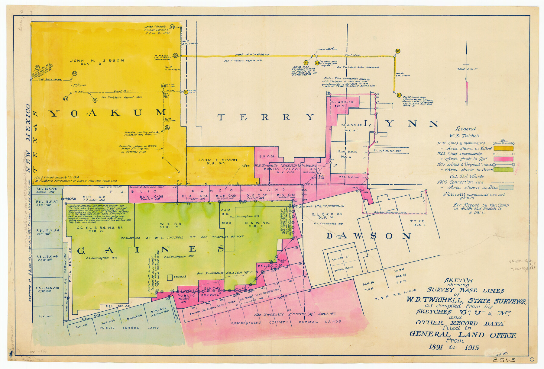
Sketch Showing Survey Base Lines of W. D. Twichell, State Surveyor as compiled from his Sketches "G", "J" and "M" and other record data filed in General Land Office from 1891 to 1915
251-5
Part of: Twichell Survey Records
[Survey 9, Block 9 Potter and Randall]
![91720, [Survey 9, Block 9 Potter and Randall], Twichell Survey Records](https://historictexasmaps.com/wmedia_w700/maps/91720-1.tif.jpg)
Print $20.00
- Digital $50.00
[Survey 9, Block 9 Potter and Randall]
Size 22.3 x 15.9 inches
Map/Doc 91720
[S. S. Evans surs. 1-4, Capitol Leagues 489-491 and vicinity]
![90418, [S. S. Evans surs. 1-4, Capitol Leagues 489-491 and vicinity], Twichell Survey Records](https://historictexasmaps.com/wmedia_w700/maps/90418-1.tif.jpg)
Print $20.00
- Digital $50.00
[S. S. Evans surs. 1-4, Capitol Leagues 489-491 and vicinity]
Size 21.7 x 16.9 inches
Map/Doc 90418
Plat in Pecos County, Texas

Print $20.00
- Digital $50.00
Plat in Pecos County, Texas
Size 21.4 x 14.9 inches
Map/Doc 91673
[Block RG, Sections 1, 2, and 16, North Line of San Augustine County School Land]
![91392, [Block RG, Sections 1, 2, and 16, North Line of San Augustine County School Land], Twichell Survey Records](https://historictexasmaps.com/wmedia_w700/maps/91392-1.tif.jpg)
Print $20.00
- Digital $50.00
[Block RG, Sections 1, 2, and 16, North Line of San Augustine County School Land]
Size 25.7 x 12.4 inches
Map/Doc 91392
Sheet 5 copied from Champlin Book 5 [Strip Map showing T. & P. connecting lines]
![93180, Sheet 5 copied from Champlin Book 5 [Strip Map showing T. & P. connecting lines], Twichell Survey Records](https://historictexasmaps.com/wmedia_w700/maps/93180-1.tif.jpg)
Print $40.00
- Digital $50.00
Sheet 5 copied from Champlin Book 5 [Strip Map showing T. & P. connecting lines]
1909
Size 7.9 x 75.6 inches
Map/Doc 93180
Sketch in Dawson County

Print $20.00
- Digital $50.00
Sketch in Dawson County
Size 18.7 x 12.4 inches
Map/Doc 92567

[Blocks D3 and GP]
![91505, [Blocks D3 and GP], Twichell Survey Records](https://historictexasmaps.com/wmedia_w700/maps/91505-1.tif.jpg)
Print $20.00
- Digital $50.00
[Blocks D3 and GP]
Size 18.9 x 20.2 inches
Map/Doc 91505
[Morris County School Land Leagues and vicinity]
![90336, [Morris County School Land Leagues and vicinity], Twichell Survey Records](https://historictexasmaps.com/wmedia_w700/maps/90336-1.tif.jpg)
Print $20.00
- Digital $50.00
[Morris County School Land Leagues and vicinity]
Size 14.3 x 12.7 inches
Map/Doc 90336
[Blocks C4, S1, K and C3 in Northern Hale/Southern Swisher Counties]
![91858, [Blocks C4, S1, K and C3 in Northern Hale/Southern Swisher Counties], Twichell Survey Records](https://historictexasmaps.com/wmedia_w700/maps/91858-1.tif.jpg)
Print $2.00
- Digital $50.00
[Blocks C4, S1, K and C3 in Northern Hale/Southern Swisher Counties]
1906
Size 15.0 x 8.7 inches
Map/Doc 91858
[I. & G. N. Block 1, sections 57-70]
![89833, [I. & G. N. Block 1, sections 57-70], Twichell Survey Records](https://historictexasmaps.com/wmedia_w700/maps/89833-1.tif.jpg)
Print $20.00
- Digital $50.00
[I. & G. N. Block 1, sections 57-70]
Size 42.0 x 36.5 inches
Map/Doc 89833
General Highway Map Cochran County, Texas

Print $20.00
- Digital $50.00
General Highway Map Cochran County, Texas
1948
Size 18.7 x 25.6 inches
Map/Doc 92498
You may also like
San Jacinto River and Tributaries, Texas - Survey of 1939

Print $20.00
- Digital $50.00
San Jacinto River and Tributaries, Texas - Survey of 1939
1939
Size 28.1 x 40.5 inches
Map/Doc 3153
Guadalupe County Sketch File 16

Print $22.00
- Digital $50.00
Guadalupe County Sketch File 16
Size 15.7 x 12.4 inches
Map/Doc 24694
Flight Mission No. CGI-3N, Frame 170, Cameron County

Print $20.00
- Digital $50.00
Flight Mission No. CGI-3N, Frame 170, Cameron County
1954
Size 18.6 x 22.3 inches
Map/Doc 84634
Presidio County Working Sketch 110

Print $20.00
- Digital $50.00
Presidio County Working Sketch 110
1981
Size 38.7 x 32.2 inches
Map/Doc 71787
Palo Pinto County

Print $40.00
- Digital $50.00
Palo Pinto County
1941
Size 48.3 x 39.4 inches
Map/Doc 66966
Zavala County Sketch File 23

Print $4.00
- Digital $50.00
Zavala County Sketch File 23
1885
Size 14.4 x 8.8 inches
Map/Doc 41380
San Patricio County Sketch File 10

Print $8.00
San Patricio County Sketch File 10
1847
Size 13.3 x 8.4 inches
Map/Doc 36040
Cooke County Sketch File 3a

Print $20.00
- Digital $50.00
Cooke County Sketch File 3a
Size 18.8 x 10.4 inches
Map/Doc 11170
Upton County Working Sketch 51

Print $20.00
- Digital $50.00
Upton County Working Sketch 51
1980
Size 19.1 x 30.0 inches
Map/Doc 69548
Hardeman County Sketch File 19

Print $6.00
- Digital $50.00
Hardeman County Sketch File 19
Size 14.3 x 8.8 inches
Map/Doc 25030
McMullen County Working Sketch 43

Print $20.00
- Digital $50.00
McMullen County Working Sketch 43
1980
Size 35.2 x 28.1 inches
Map/Doc 70744
Jefferson County Working Sketch 13

Print $20.00
- Digital $50.00
Jefferson County Working Sketch 13
1948
Size 13.5 x 20.1 inches
Map/Doc 66556