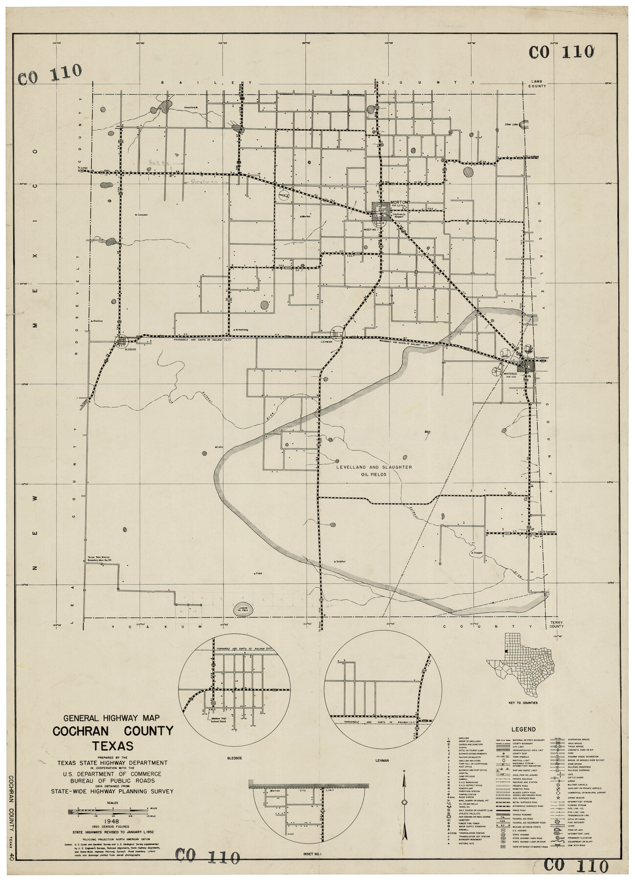
General Highway Map Cochran County, Texas
CO110
-
Map/Doc
92498
-
Collection
Twichell Survey Records
-
Object Dates
1948 (Creation Date)
-
Counties
Cochran
-
Subjects
County
-
Height x Width
18.7 x 25.6 inches
47.5 x 65.0 cm
Part of: Twichell Survey Records
[Block W, A4, & Part of CL, East Line Sabine County School Land]
![90699, [Block W, A4, & Part of CL, East Line Sabine County School Land], Twichell Survey Records](https://historictexasmaps.com/wmedia_w700/maps/90699-1.tif.jpg)
Print $20.00
- Digital $50.00
[Block W, A4, & Part of CL, East Line Sabine County School Land]
Size 27.5 x 16.6 inches
Map/Doc 90699
Working Sketch, Garza County

Print $20.00
- Digital $50.00
Working Sketch, Garza County
1904
Size 13.9 x 14.7 inches
Map/Doc 92693
Subdivision Map of Childress County School Land Situated in Bailey and Cochran Counties, Texas

Print $20.00
- Digital $50.00
Subdivision Map of Childress County School Land Situated in Bailey and Cochran Counties, Texas
Size 23.0 x 26.4 inches
Map/Doc 92526
[S.P.R.R.Co. Blocks 15 &16]
![92355, [S.P.R.R.Co. Blocks 15 &16], Twichell Survey Records](https://historictexasmaps.com/wmedia_w700/maps/92355-1.tif.jpg)
Print $20.00
- Digital $50.00
[S.P.R.R.Co. Blocks 15 &16]
Size 37.3 x 32.3 inches
Map/Doc 92355
[Blocks C34, C44, C40, C42, C31-C38, A19 and others in vicinity]
![93210, [Blocks C34, C44, C40, C42, C31-C38, A19 and others in vicinity], Twichell Survey Records](https://historictexasmaps.com/wmedia_w700/maps/93210-1.tif.jpg)
Print $40.00
- Digital $50.00
[Blocks C34, C44, C40, C42, C31-C38, A19 and others in vicinity]
Size 71.0 x 55.2 inches
Map/Doc 93210
[Sketch showing Block 42, Sections 221 and 222 and Block H, Sections 7 and 9]
![91714, [Sketch showing Block 42, Sections 221 and 222 and Block H, Sections 7 and 9], Twichell Survey Records](https://historictexasmaps.com/wmedia_w700/maps/91714-1.tif.jpg)
Print $2.00
- Digital $50.00
[Sketch showing Block 42, Sections 221 and 222 and Block H, Sections 7 and 9]
1919
Size 5.6 x 5.0 inches
Map/Doc 91714
[Leagues 615 ,616, and 242]
![91064, [Leagues 615 ,616, and 242], Twichell Survey Records](https://historictexasmaps.com/wmedia_w700/maps/91064-1.tif.jpg)
Print $20.00
- Digital $50.00
[Leagues 615 ,616, and 242]
Size 12.9 x 13.5 inches
Map/Doc 91064
Castro County, Texas

Print $20.00
- Digital $50.00
Castro County, Texas
Size 20.3 x 22.8 inches
Map/Doc 92613
[Capitol Leagues 217-228, 238, and vicinity]
![90672, [Capitol Leagues 217-228, 238, and vicinity], Twichell Survey Records](https://historictexasmaps.com/wmedia_w700/maps/90672-1.tif.jpg)
Print $20.00
- Digital $50.00
[Capitol Leagues 217-228, 238, and vicinity]
Size 23.0 x 9.9 inches
Map/Doc 90672

Map Showing Eastern Portion of Pecos County, Texas

Print $40.00
- Digital $50.00
Map Showing Eastern Portion of Pecos County, Texas
Size 62.2 x 43.5 inches
Map/Doc 89835
[I. & G. N. Block 1, Runnels County School Land, T. C. Ry. Co. Block Z and G. C. & S. F. RR. Co. Block C-4]
![91661, [I. & G. N. Block 1, Runnels County School Land, T. C. Ry. Co. Block Z and G. C. & S. F. RR. Co. Block C-4], Twichell Survey Records](https://historictexasmaps.com/wmedia_w700/maps/91661-1.tif.jpg)
Print $20.00
- Digital $50.00
[I. & G. N. Block 1, Runnels County School Land, T. C. Ry. Co. Block Z and G. C. & S. F. RR. Co. Block C-4]
Size 29.7 x 17.9 inches
Map/Doc 91661
You may also like
Taylor County Sketch File 21

Print $10.00
- Digital $50.00
Taylor County Sketch File 21
1962
Size 11.3 x 8.8 inches
Map/Doc 37821
Kaufman County Working Sketch 1

Print $20.00
- Digital $50.00
Kaufman County Working Sketch 1
1921
Size 21.4 x 47.6 inches
Map/Doc 66664
Sterling County Working Sketch 6

Print $40.00
- Digital $50.00
Sterling County Working Sketch 6
1955
Size 38.1 x 121.6 inches
Map/Doc 63988
Robertson County Working Sketch 2

Print $20.00
- Digital $50.00
Robertson County Working Sketch 2
1939
Size 14.5 x 16.3 inches
Map/Doc 63575
Comanche County Working Sketch 6

Print $20.00
- Digital $50.00
Comanche County Working Sketch 6
1935
Size 26.4 x 17.8 inches
Map/Doc 68140
Flight Mission No. DCL-7C, Frame 95, Kenedy County

Print $20.00
- Digital $50.00
Flight Mission No. DCL-7C, Frame 95, Kenedy County
1943
Size 15.4 x 15.2 inches
Map/Doc 86067

Kleberg County Boundary File 4a

Print $40.00
- Digital $50.00
Kleberg County Boundary File 4a
Size 23.3 x 62.2 inches
Map/Doc 64997
Sketch of Colorado Co. presented by Mr. Mason

Print $2.00
- Digital $50.00
Sketch of Colorado Co. presented by Mr. Mason
1845
Size 14.3 x 8.2 inches
Map/Doc 69736
[Surveys in Southeast part of Stephens County]
![91909, [Surveys in Southeast part of Stephens County], Twichell Survey Records](https://historictexasmaps.com/wmedia_w700/maps/91909-1.tif.jpg)
Print $2.00
- Digital $50.00
[Surveys in Southeast part of Stephens County]
Size 9.1 x 7.0 inches
Map/Doc 91909
Lubbock County Sketch File 1

Print $20.00
- Digital $50.00
Lubbock County Sketch File 1
1884
Size 22.5 x 27.6 inches
Map/Doc 12015
Port Facilities at Texas City, Tex.

Print $20.00
- Digital $50.00
Port Facilities at Texas City, Tex.
1924
Size 13.9 x 15.9 inches
Map/Doc 97161