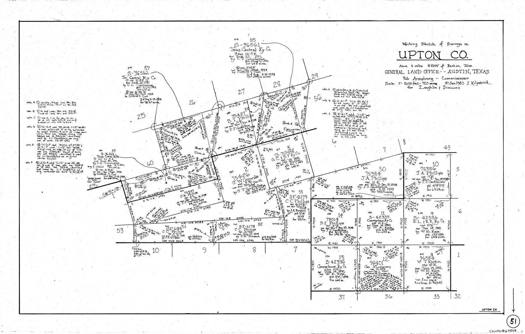
Upton County Working Sketch 51
-
Map/Doc
69548
-
Collection
General Map Collection
-
Object Dates
1/30/1980 (Creation Date)
-
People and Organizations
Joan Kilpatrick (Draftsman)
-
Counties
Upton
-
Subjects
Surveying Working Sketch
-
Height x Width
19.1 x 30.0 inches
48.5 x 76.2 cm
-
Scale
1" = 720 varas
Part of: General Map Collection
Controlled Mosaic by Jack Amman Photogrammetric Engineers, Inc - Sheet 30

Print $20.00
- Digital $50.00
Controlled Mosaic by Jack Amman Photogrammetric Engineers, Inc - Sheet 30
1954
Size 20.0 x 24.0 inches
Map/Doc 83483
Map of Copano, St. Charles, Aransas & Red Fish Bays in Aransas & Nueces Counties showing subdivision thereof for Mineral Development

Print $20.00
- Digital $50.00
Map of Copano, St. Charles, Aransas & Red Fish Bays in Aransas & Nueces Counties showing subdivision thereof for Mineral Development
1939
Size 35.9 x 34.4 inches
Map/Doc 2296
Bandera County Working Sketch 49

Print $20.00
- Digital $50.00
Bandera County Working Sketch 49
1983
Size 28.2 x 43.3 inches
Map/Doc 67645
Map of north end of Brazos Island

Print $20.00
- Digital $50.00
Map of north end of Brazos Island
Size 27.7 x 18.3 inches
Map/Doc 72907
Township No. 2 South Range No. 20 West of the Indian Meridian

Print $20.00
- Digital $50.00
Township No. 2 South Range No. 20 West of the Indian Meridian
1875
Size 19.2 x 24.5 inches
Map/Doc 75180
Yoakum County Rolled Sketch 2

Print $20.00
- Digital $50.00
Yoakum County Rolled Sketch 2
1943
Size 18.6 x 33.4 inches
Map/Doc 8288
Harris County Sketch File 80b

Print $20.00
- Digital $50.00
Harris County Sketch File 80b
Size 31.5 x 17.2 inches
Map/Doc 11668
Kinney County Sketch File E1

Print $20.00
- Digital $50.00
Kinney County Sketch File E1
1885
Size 29.8 x 31.9 inches
Map/Doc 10619
Map of Brewster Co.

Print $40.00
- Digital $50.00
Map of Brewster Co.
1896
Size 58.4 x 17.3 inches
Map/Doc 4892
Ector County Rolled Sketch 13

Print $40.00
- Digital $50.00
Ector County Rolled Sketch 13
1957
Size 49.2 x 32.0 inches
Map/Doc 8841
Rockport Quadrangle

Print $20.00
- Digital $50.00
Rockport Quadrangle
1954
Size 21.3 x 18.3 inches
Map/Doc 73435
Foard County Sketch File 35

Print $20.00
- Digital $50.00
Foard County Sketch File 35
Size 25.2 x 24.8 inches
Map/Doc 6067
You may also like
Dallam Co. Texas, Standard Single County Oil Development Survey

Print $20.00
- Digital $50.00
Dallam Co. Texas, Standard Single County Oil Development Survey
Size 20.7 x 15.8 inches
Map/Doc 90583
Harris County Sketch File 80a

Print $20.00
- Digital $50.00
Harris County Sketch File 80a
1892
Size 27.8 x 17.6 inches
Map/Doc 11667
![94181, San Antonio [Recto], General Map Collection](https://historictexasmaps.com/wmedia_w700/maps/94181.tif.jpg)
Bee County Sketch File 32

Print $4.00
- Digital $50.00
Bee County Sketch File 32
Size 7.9 x 12.6 inches
Map/Doc 14347
Map of Kimble County

Print $20.00
- Digital $50.00
Map of Kimble County
1876
Size 19.2 x 29.8 inches
Map/Doc 3768
Kerr County Working Sketch 11

Print $20.00
- Digital $50.00
Kerr County Working Sketch 11
1951
Size 30.3 x 29.9 inches
Map/Doc 70042
Williamson County Sketch File 16

Print $20.00
- Digital $50.00
Williamson County Sketch File 16
Size 16.8 x 25.5 inches
Map/Doc 12693
Midland County Working Sketch 19a

Print $20.00
- Digital $50.00
Midland County Working Sketch 19a
Size 20.2 x 23.4 inches
Map/Doc 71000
Wheeler County Sketch File A

Print $20.00
- Digital $50.00
Wheeler County Sketch File A
1888
Size 15.5 x 31.8 inches
Map/Doc 12677
San Jacinto County Rolled Sketch 14

Print $20.00
- Digital $50.00
San Jacinto County Rolled Sketch 14
1998
Size 25.7 x 37.2 inches
Map/Doc 7570
The Fisher-Miller Colony. June 7, 1842

Print $20.00
The Fisher-Miller Colony. June 7, 1842
2020
Size 13.8 x 21.7 inches
Map/Doc 96358
